Oregon, USA
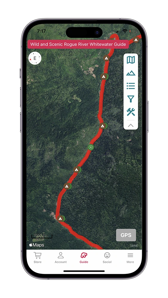
Wild & Scenic Rogue River guide
The famous Wild and Scenic Rogue. Probably the most popular multi-day rafting trip on the west coast. And for good reason too. Amazing wildlife, warm water, exhilarating but not terrifying rapids and easy camping make it a great all in one river trip.


Based in Southern Oregon, Indigo Creek Outfitters is our preferred partner for the Rogue river. In addition to the Rogue they operate on the Upper and Lower Klamath and Nugget section of the Rogue. Learn more about Indigo Creek Outfitters.
About this guide
This guide outlines the most common run on the Rogue River from Grave Creek to Foster Bar.
Matching our data with the BLM’s guidebook is critical on the Rogue as there are many campgrounds that are often very close together. If there were discrepancies it could potentially cause issues in the field. Because of this, we worked to align our data as best as possible with the BLM’s. To achieve this we were granted access to the waypoints that the BLM recorded and for the most part have used these exact waypoints. If there were adjustments made, that is noted in the data. Of note and as expected, there is a slight variation in mileage recorded.
Permits
A float permit is required year-round for this section of the Rogue River. A lottery is used to allocate the control season (May 15 – October 15) launches. All trips are required to pick up their permits at the Smullin Visitor Center at the Rand Ranger Station on the day of your launch. Pre- and post-control season launches are obtained by filling out a self-issued permit available at the Smullin Visitor Center and Grave Creek Boat Launch access. Additional permit information can be found here.
Shuttles
Roundtrip the shuttle is long, so it’s worth spending the money and hiring a shuttle service. Click here for shuttle information.
Blossom Bar Rapid
While Rainey Falls is the highest rated rapid on the Rogue River, Blossom Bar tends to be a more formidable challenger. A scout at this rapid is recommended.
Rafting the Rogue River? Our Wild & Scenic Rogue River guide has you covered: 226 waypoints | Live location | 104 photos.
$9.99 – Powered by FarOut
4.8★★★★★ 25K+ Reviews
Wild and Scenic Run – Class I, II, & III+
The Wild and Scenic section of the Rogue River is the most popular multi-day on the West Coast, and for good reason. It has amazing wildlife, fun rapids, warm water, and easy camping.
Mile 0 – Grave Creek Boat Ramp:
River Right. This is the start of the Wild and Scenic section of the Rogue. It’s just downstream of the Grave Creek Bridge and Grave Creek confluence. At this point, the road following the river pulls away and won’t be seen again. The ramp here isn’t very large, so please be courteous to others. There are outhouses located here. Learn more about the Grave Creek Boat Ramp.
Mile 0.04 – Grave Creek Riffle:
Class III. At low water this rapid is split by an island mid river. Enter on the right side of the left channel and pull or push to stay off the left wall. At below 2,000 CFS a sneaky mid river boulder emerges at the bottom of the rapid, so style the exit by threading the needle between this and the left wall. Beware of a small ducky magnet eddy on the left wall just before the exit.
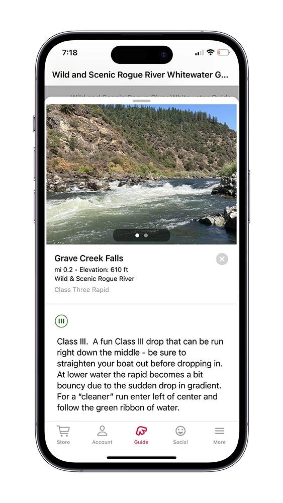
Mile 0.23 – Grave Creek Falls:
Class III. A fun Class III drop that can be run right down the middle, just be sure to straighten your boat out before dropping in. At lower water the rapid becomes a bit pitchy due to it’s sudden drop in gradient, so for a “cleaner” run enter left of center and follow the green ribbon of water.
Mile 0.45 – First Stop Beach:
River Left. This is a medium sized camp. BLM has scouted it to fit up to 8 people with 5 tents and 8 boats.
Mile 0.52 – Main Sanderson:
River Right. This is a small camp. BLM has scouted it to fit up to 2 people, 1 tent and 8 boats.8 boats. Note that the BLM data file had a bad pin for this camp and we have adjusted it.
Mile 0.56 – Lower Sanderson:
River Right. This is a small camp. BLM has scouted it to fit up to 6 people, 2 tents and 3 boats.
Mile 0.6 – Sanderson Left:
River Left. This is a small camp. BLM has scouted it to fit up to 2 people, 1 tent and 2 boats. Note that the BLM data file had a bad pin for this camp and we have adjusted it to where we believe they intended.
Mile 0.75 – Sanderson Bar:
River Left. This is a small camp. Note that this camp is not part of the BLM camp list.
Mile 0.76 – Sanderson Island:
This island is a large cobble bar named after the Sanderson Brothers, Clayton and Clifton, who homesteaded in the Rogue Valley during the mid 1900s. Here they maintained a cabin and garden, while trading with the outside world to acquire other goods. As remembered by their nephew, Clifton was a people pleaser, and made elderberry wine to use for trading and host guests. Clayton kept the house running and was the “brains” of the operation. They lived and worked in the Rogue Canyon all the way into their 80s.
Mile 0.76 – Sanderson Riffle:
Class II. Read and run rapid in the left channel of Sanderson Island. At certain water levels this rapid provides a fun surf wave for smaller river crafts, so be on the lookout! At the bottom of this riffle around the island, there is a wooden plaque mounted about 50 feet up the cliff on river right. It marks the level of the river on December 23, 1964, during a high water flood.
Mile 1.05 – Sanderson Bridge Abutments:
River Left. Keep a lookout for old concrete pillars that remain from a bridge that crossed the river here in the early 1900s. Once used by pack mules and those traveling on foot, the bridge was wiped out by the 1927 flood.
Mile 1.53 – Rainie Falls Left:
River Left. This is a small camp. BLM has scouted it to fit up to 2 people, 1 tent and 5 boats. Note that the BLM data file had a bad pin for this camp and we have adjusted it to where we believe they intended.
Mile 1.55 – Rainie Falls Right Camp:
River Right. This is a medium sized camp. BLM has scouted it to fit up to 12 people, 6 tents and 5 boats.
Mile 1.66 – Rainie Falls Fish Ladder:
Class III. The fish ladder is the man-made channel on the furthest right side of Rainie Falls. This is the most standard run for this rapid. Learn more about the Fish Ladder.
Mile 1.66 – Middle Chute:
Class IV. The more exciting line than the fish ladder is the Middle Chute. This channel is sometimes the only option for rafts too big for the fish ladder. Learn more about the Middle Chute and Rainie Falls.
Mile 1.66 – Rainie Falls:
Class V. The main drop is big and features large hyraulics. It is considered Class V. Even if you don’t plan on running it (not recommended) it’s fun to park your raft upstream on river left hike down and take a look. Learn more about the Rainie Falls.
Mile 1.79 – Upper Fishermans Haven:
River Left. This is a small camp. BLM has scouted it to fit up to 6 people, 3 tents and 5 boats.
Mile 1.88 – Whoo Beach:
River Right. This is a small camp. BLM has scouted it to fit up to 6 people, 3 tents and 6 boats.
Mile 1.9 – Fishbone:
River Left. This is a medium sized camp. BLM has scouted it to fit up to 8 people, 5 tents and 8 boats.
Mile 2.0 – China Gulch:
River Right. This is a medium sized camp. BLM has scouted it to fit up to 10 people, 5 tents and 5 boats.
Mile 2.1 – China Gulch Riffles:
Class II. A series of Class II read and run riffles. Named after Chinese miners that worked in the 1800s mining and helping dig water ditches for homesteads in the river valley.
Mile 2.4 – Pre-rum Creek:
River Left. This is a small camp. BLM has scouted it to fit up to 4 people, 2 tents and 8 boats.
Mile 2.48 – Too Tires:
River Right. This is a small camp. BLM has scouted it to fit up to 2 people, 1 tents and 2 boats.
Mile 2.96 – Whiskey Creek:
River Right. This is a large camp. Also known as Upper Whiskey Creek. BLM has scouted it to fit up to 30 people, 15 tents and 11 boats.
Mile 2.98 – Rum Creek:
River Left. Rum Creek tumbles in here, This used to be a camp, but is no longer a viable option here.
Mile 2.99 – Whisky Creek Cabin:
River Right. Located a short ways up Whisky Creek, this cabin was first constructed in 1880 by an unknown miner. It’s original structure resembled more of a makeshift lean-to than a cabin. In 1917, a man named P.Y Rushmore filed the first mining claim for the area, and in 1918 the claim (and cabin) was sold to Cy Whitneck. Over the years the cabin passed through different caretakers, and multiple improvements were made. One renovation was a solar shower that still remains today! The cabin’s last resident left in the early 1970s, and today the site is on the National Register of Historic Places as the oldest mining cabin still standing in the Rogue River Valley.
Mile 3.03 – Lower Whiskey:
River Right. This is a large camp. BLM has scouted it to fit up to 20 people, 12 tents and 6 boats.
Mile 3.2 – Lower Rum Creek Bar:
River Left. This is a medium sized camp. BLM has scouted it to fit up to 12 people, 6 tents and 12 boats.
Mile 3.2 – Big Slide Riffle:
Class I. No longer a significant feature but this was the location of a giant landslide that backed the river up for miles in the late 1800s.
Mile 3.22 – BLS:
River Left. This is a medium sized camp. BLM has scouted it to fit up to 12 people, 6 tents and 12 boats.
Mile 3.29 – Cave Rock:
River Left. This is a medium sized camp. Some boaters call this Big Slide Left. Good swimming opportunities here. BLM has scouted it to fit up to 16 people, 8 tents and 11 boats.
Mile 3.46 – Doe Creek Camp:
River Left. This is a large camp. BLM has scouted it to fit up to 20 people, 20 tents and 10 boats.
Mile 3.46 – Fawn:
River Right. This is a small camp. BLM has scouted it to fit up to 6 people, 4 tents and 2 boats.
Mile 3.59 – Buck:
River Left. This is a small camp. BLM has scouted it to fit up to 4 people, 2 tents and 4 boats.
Mile 4.13 – Tyee Rapid :
Class III. River bends to the left, with a large house rock on the left side. Current is pushing into wall on river right, so work left to avoid getting pushed into this wall. Learn more about Tyee Rapid.
Mile 4.33 – Tyee Camp:
River Right. This is a large camp. BLM has scouted it to fit up to 20+ people, 10 tents and 10 boats. Learn more about Tyee Camp.
Mile 4.55 – Wildcat Rapid:
Class III. Here the river is split by a large island, dividing the flow into two channels. The right channel is most commonly taken. The primary features of this rapid include willows overhanging on the bank of the right channel and a wrap rock at the bottom center of the rapid. Learn more about Wildcat Rapid.
Mile 4.89 – Upper Wildcat:
River Left. This is a large camp. BLM has scouted it to fit up to 20+ people, 10 tents and 10 boats.
Mile 5.0 – Wildcat:
River Left. Large. Also known as Lower Wildcat. BLM has scouted it to fit up to 20+ people, 10 tents and 10 boats.
Mile 5.12 – Russian Rapid :
Class II. Named after a Russian miner that lived in the Rogue Valley during the late 1800s who- as legend has it- did not speak a word of English but simply traded in gold to acquire supplies. Enter left of center with a right angle to square up to a lateral that surges off the river right bank. After the lateral, work your way to the right to avoid a ducky flipping hole located on river left towards the end of the rapid. If unable to avoid the hole; straighten out, get momentum, and punch through.
Mile 5.42 – Montgomery Chutes:
Class II. A series of connected read and run rapids. At lower water levels the left side of these rapids are typically cleaner.
Mile 5.68 – Howard Creek Chutes:
Class II. A series of fun wave trains. Be sure to take the river left route for the third wave train, as a sieve like rock in the center creates a funky feature.
Mile 5.96 – Howard Creek:
River Left. Just downstream of Howard Creek Rapids, Howard enters from the left. This is a popular swimming hole, just a quick scramble up Howard Creek. Typically two to three rafts can fit in and tie up at the mouth of the creek. Learn more about Howard Creek.
Mile 6.23 – Slanted Slate:
River Left. This is a small camp. BLM has scouted it to fit up to 6 people, 3 tents and 4 boats. Learn more about Slanted Slate camp here.
Mile 6.76 – Slim Pickins Rapid:
Class III. Defined by a large rock that splits the river in two. Although a relatively easy rapid for rafts, this rapid is one of the most difficult for drift boats. Unable to take passage on the left hand side of the rock due to its shallow nature, drift boats must take the narrow right channel. Rafts can run on either side of the rock, but unless you have previous experience with the rapid and your oar management is beyond superb, the left side is recommended. Learn more about Slim Pickins Rapid here.
Mile 7.0 – Roll Over Bar:
River Right. This is a medium sized camp. BLM has scouted it to fit up to 10 people, 4 tents and 5 boats.
Mile 7.32 – Island Beach:
River Left. This is a small camp. Often used as a lunch spot. BLM has scouted it to fit up to 6 people, 3 tents and 7 boats.
Mile 7.38 – Washboard Rapids:
Class II. Fun read-and-run wave train.
Mile 7.47 – Gravel Slide:
River Right. This is a small camp. BLM has scouted it to fit up to 4 people, 2 tents and 3 boats.
Mile 7.51 – Plowshare Rapid:
Class II. The river constricts as the left bank turns into a wall, forming a rapid that acts as precursor to the swirlies and boils of Mule Creek. Read and run, but be on your toes: The rapid’s swirly nature provides plenty of opportunities to bump into either bank. Watch out for a pocket eddy that forms against the left wall after the entrance (known to be a raft magnet).
Mile 7.64 – Sand Rock:
River Left. This is a small camp. BLM has scouted it to fit up to 6 people, 3 tents and 3 boats.
Mile 7.81 – Gravel Garden:
River Right. This is a small camp. BLM has scouted it to fit up to 6 people, 3 tents and 3 boats.
Mile 7.84 – Sand Trap:
River Right. This is a small camp. BLM has scouted it to fit up to 6 people, 3 tents and 3 boats.
Mile 7.92 – Windy Creek Chutes:
Class II. Here the river narrows into a series of two fun chutes. Both have clear tongue entries. At lower water levels the passages narrow, so be prepared to ship an oar or two.
Mile 8.06 – Big Windy Camp:
River Left. This camp is a rocky carry but the reward is the access to Big Windy Creek, which is just downstream. This is a medium sized camp. BLM has scouted it to fit up to 8 people, 4 tents and 4 boats.
Mile 8.08 – Big Windy Creek:
River Left. This is a beautiful creek with a swimming hole that’s great for cooling off on hot days.
Mile 8.24 – Upper Black Bar:
River Right. This is a small camp. BLM has scouted it to fit up to 2 people, 1 tents and 4 boats.
Mile 8.28 – Upper Black Bar Falls:
Class III. This rapid can be scouted just upstream on river right by pulling into a small rock alcove and scrambling up the bank. The center and left side of the rapid is littered with rocks, so the right line is optimal. Enter just to the right of a small boulder positioned about 15 feet from the right bank (at lower water levels this will become a goalpost move between this boulder and a submerged boulder further to the right. As the current carries you down the rapid, be aware of your oars and angle to avoid bumping into the right wall. Exit between the right wall and another boulder on the left.
Mile 8.4 – Lower Black Bar Falls:
Class III. As once put by a guide: “A significant drop in gradient!”. A fun, steep wave train that can be run right down the middle. This rapid has an occasional tendency to send you into a large rock sticking out from the left bank, so be prepared for a bump.
Mile 8.69 – Black Bar Lodge:
River Left. This is the first lodge you’ll come across, so if you are doing an all lodge trip, you’ll likely be staying here. Learn more about Black Bar Lodge.
Mile 9.1 – Little Windy:
River Left. This is a medium sized camp. BLM has scouted it to fit up to 15 people, 7 tents and 8 boats.
Mile 9.17 – Little Windy Riffle:
Class II. Lovingly referred to as Eddy Ally by kayakers. This class II riffle is read and run, but has fun little features to play around in if you are in a smaller craft.
Mile 9.97 – Upper Jenny:
River Left. This is a small camp. BLM has scouted it to fit up to 6 people, 3 tents and 5 boats.
Mile 10.02 – Jenny Creek:
River Left. This is a medium sized camp. BLM has scouted it to fit up to 16 people, 8 tents and 7 boats.
Mile 10.33 – Horsehoe Bend:
Class III. Named for the horseshoe shape the river makes by bending quickly to the right and then left. The entrance of this rapid is mellow: Follow a small riffle that parallels the left bank. At the end of this riffle there will be a bedrock island mid-river. Pass the island on its left side. After going to the left of the island, immediately work your way to river right. Set up your angle and take deliberate strokes to stay on the inside of the turn. As you round the corner after Horseshoe Bend, there is a little riffle with whirlpools prime for stern squirting in a hardshell kayak.
Mile 10.36 – Upper Horseshoe Bend:
River Right. This is a large camp. BLM has scouted it to fit up to 20+ people, 8 tents and 8 boats.
Mile 10.48 – Horseshoe Bend:
River Right. This is a large camp. BLM has scouted it to fit up to 20+ people, 12 tents and 8 boats.
Mile 10.71 – Madrone Monkey / Cowley Creek:
River Right. This is a small camp. Also known as Cowley Creek Camp. BLM has scouted it to fit up to 6 people, 3 tents and 3 boats.
Mile 10.89 – Middle Horseshoe Bend:
River Right. This is a medium sized camp. BLM has scouted it to fit up to 12 people, 6 tents and 8 boats.
Mile 10.97 – Lower Horseshoe Bend:
River Right. This is a large camp. BLM has scouted it to fit up to 20+ people, 12 tents and 12 boats.
Mile 11.04 – Telephone Bar Left Camp:
River Left. This is a small camp. BLM has scouted it to fit up to 6 people, 3 tents and 10 boats.
Mile 11.06 – Bar View:
River Right. This is a small camp. BLM has scouted it to fit up to 4 people, 2 tents and 2 boats.
Mile 11.31 – Telephone Hole:
Class II. Named after a US Forest Service telephone line that once crossed the river here. Read and run. This rapid’s primary feature is a ducky flipping hole on river left.
Mile 11.4 – Mary’s Beach:
River Right. This is a small camp. Also known as Upper Meadow Camp. BLM has scouted it to fit up to 6 people, 3 tents and 6 boats.
Mile 11.58 – Meadow Creek:
River Right. This is a medium sized camp. BLM has scouted it to fit up to 14 people, 7 tents and 7 boats.
Mile 12.08 – Dulog Riffle:
Class II. This rapid forms as the river makes a slight left hand turn. Enter on river left, staying on the inside of the turn. Follow the main flow of current and exit between two boulders mid river (at higher water levels the rightmost boulder is submerged and forms a hole).
Mile 12.19 – Dulog:
River Left. This is a medium sized camp. Also known as Upper Dulog. BLM has scouted it to fit up to 10 people, 5 tents and 6 boats.
Mile 12.27 – Start of Kelsey Canyon:
Quiz Show marks the start of Kelsey Canyon.
Mile 12.27 – Quiz Show rapid:
Class III. Quiz Show is a boulder garden rapid. Move slow, and pick your way through the numerous channels.
Mile 12.31 – Lower Dulog Camp:
River Left. This is a medium sized camp. BLM has scouted it to fit up to 10 people, 5 tents and 5 boats. Note that we slightly adjusted the BLM GPS pin for this camp.
Mile 12.77 – Kelsey Creek Falls:
Class II. A fun wave train on river left that forms between the left bank and a mid-river boulder. Hey diddle diddle right down the middle.
Mile 12.9 – Lower Kelsey:
Class II. Another fun wave train that can be run right down the middle. In previous years there has been a log perched on a rock mid-river at the entrance of this rapid. Pass to the right of the log and cruise down the rapid.
Mile 13.25 – Kelsey Creek:
River Right. Kelsey Creek tumbles into the Rogue River from river right. This is a nice hike if you’ve got a little extra time for exploring.
Mile 13.28 – Kelsey Creek Camp:
River Right. This is a medium sized camp. BLM has scouted it to fit up to 8 people, 4 tents and 4 boats.
Mile 13.43 – Upper Kelsey Left:
River Left. This is a large camp. Two large sandy camps are split by a rock outcrop. The first of these camps is known as Upper Kelsey Left. BLM has scouted it to fit up to 20+ people, 15 tents and 10 boats. Please note that we slightly adjusted the BLM GPS pin. This is referenced as Lower Kelsey in the guidebook.
Mile 13.47 – Lower Kelsey Left / Terraces:
River Left. This is a large camp. Keep in mind that this camp does not appear on the BLM guidebook, but this is recognized as an additional camp in the boating community.
Mile 13.49 – Kelsey Canyon Overflow:
River Right. This is a small camp. Also known as Geology Camp. BLM has scouted it to fit up to 6 people, 3 tents and 3 boats. Please note that we slightly adjusted the BLM GPS pin.
Mile 13.58 – Green Rattlesnake:
River Left. This is a small camp. BLM has scouted it to fit up to 6 people, 3 tents and 3 boats. Please note that we slightly adjusted the BLM GPS pin.
Mile 13.61 – Start of Battle Bar Flats:
One of the Wild and Scenic Rogue’s most famous lakes. If luck is on your side (with downstream or no wind), this is a fun spot to jump out, swim, or have a water gun battle. Learn more about the history of Battle Bar Flats.
Mile 13.69 – Sports Illustrated Rock:
River Left. This is a large and popular jump rock. Learn more about Sports Illustrated Rock.
Mile 14.17 – Eagle Tree:
River Right. There’s a tree here that often has an eagle in it.
Mile 14.27 – Battle Bar:
River Left. This is a large camp. This camp and downstream rapid is named after a fight that occurred here during the Rogue River Indian Wars of 1855-1856. BLM has scouted it to fit up to 24 people, 12 tents and 12 boats.
Mile 14.37 – Battle Bar Riffle:
Class II. Congratulations on making it past the lake! This riffle is read and run, but it is recommended to stay towards the right. There is a fun pillow rock midway through for those who want to play.
Mile 14.98 – Haas Island:
This is a small camp. BLM has scouted it to fit up to 2 people, 1 tents and 6 boats.
Mile 15.18 – Zane Grey’s Cabin:
River Right. This cabin, built in 1926 by Zane Grey, still stands today and is protected as a historical place. Zane Grey is considered to be one of the best authors about the American West. Learn more about Zane Grey’s cabin here.
Mile 15.27 – Lower Winkle Bar Camp:
River Right. This is a medium sized camp. Easily accessible to the Zane Grey historical cabin. BLM has scouted it to fit up to 10 people, 5 tents and 5 boats.
Mile 15.48 – J and J Rock Bar:
River Left. This is a small camp. River Left. This is a small camp. BLM has scouted it to fit up to 2 people, 1 tents and 5 boats.
Mile 15.63 – J and B Rock Bar:
River Right. This is a small camp. BLM has scouted it to fit up to 6 people, 3 tents and 4 boats.
Mile 16.05 – Turtle Rock:
River Right. This is a medium sized camp. Note that this camp appears on BLM GPS files, but not on their map.
Mile 16.4 – Missouri Creek:
River Left. Missouri Creek enters the Rogue River from the left-side.
Mile 16.43 – Upper Missouri / Missouri Bar:
River Left. This is a large camp. BLM has scouted it to fit up to 20+ people, 10 tents and 10 boats.
Mile 16.47 – Middle Missouri Bar:
River Left. This is a medium sized camp. BLM has scouted it to fit up to 14 people, 6 tents and 6 boats.
Mile 16.54 – Lower Missouri:
River Left. This is a small camp. BLM has scouted it to fit up to 6 people, 4 tents and 4 boats.
Mile 16.73 – Quail Creek Camp:
River Right. This is a medium sized camp. The creek is just downstream and offers a small but refreshing pool. BLM has scouted it to fit up to 12 people, 6 tents and 6 boats.
Mile 16.8 – Corner Camp / Quail Creek Left camp:
River Left. This is a small camp. Note that BLM has the pin set approximately 100 feet downstream of this location, however, both places are available for you. BLM has scouted it to fit up to 4 people, 3 tents and 4 boats.
Mile 17.27 – Long Gulch Camp:
River Left. This is a small camp. BLM has scouted it to fit up to 6 people, 3 tents and 6 boats.
Mile 17.43 – Long Beach / Long Gulch Right:
River Right. This is a medium sized camp. Long Gulch Right Camp is a large cobbly camp. BLM has scouted it to fit up to 12 people, 5 tents and 12 boats.
Mile 17.67 – Boulder Alley:
Class II. As the name implies, this series of rapids is littered with boulders. They are all easy to avoid, but look out for rocks just below the surface that provide perching opportunities as the water drops.
Mile 17.81 – Big Boulder Rapids:
Class II. A continuation of Boulder Alley, Big Boulder Rapids ends the series with a fast chute that leads you to the right of Elephant Rock.
Mile 17.87 – Elephant Rock:
River Left, Look for the large, elephant shaped rock on the left side of the river.
Mile 18.09 – Island Rapid:
Class I. Read and run.
Mile 18.14 – Kai Beach:
River Right. This is a small camp and popular lunch spot. BLM has scouted it to fit up to 6 people, 3 tents and 4 boats.
Mile 18.32 – John’s Rapid :
Class II. Named after Tecumtum (commonly known amongst settlers as Chief John), who was the principal chief of the Etch-ka-taw-wah band of Athabaskan people during the mid-1850s). This rapid is distinguished by boulder garden sieves on both river left and right. As you get closer, the entrance will become more clear. Enter in the middle, passing to the right of a prominent boulder that sits just left of center. Follow the main wave train and watch your oars.
Mile 18.89 – Little Maggie:
River Left. This is a small camp. BLM has scouted it to fit up to 4 people, 2 tents and 3 boats.
Mile 18.94 – Maggie’s Surf Wave:
Small surf wave just downstream of Little Maggie camp.
Mile 19.5 – China Bar Rapid:
Class II. Enter on the river left. Right of center is a rock cluster that features a pointy rock known as “the can opener” or “the shark fin”. Depending on the position of the sun and its glare, the rock can appear to be part of the lower right bank, so it can be difficult to spot from upstream. Regardless, enter on river left to avoid this role pile or hole( depending on the water level). Once past, work towards river right to avoid a large boulder that protrudes from the left bank. At the rapid’s end be aware of two holes that form at lower water levels. If need be, line up and punch through each feature.
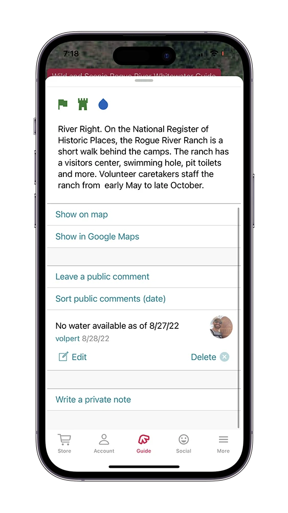
Mile 19.75 – Rogue River Ranch:
River Right. On the National Register of Historic Places, the Rogue River Ranch is a short walk behind the camps listed below. The ranch has a visitors center, swimming hole, pit toilets and more. Volunteer caretakers staff the ranch from early May to late October. Learn more about the Rogue River Ranch.
Mile 19.75 – East / Upper Rogue River Ranch:
River Right. This is a large camp. BLM has scouted it to fit up to 16 people, 8 tents and 8 boats.
Mile 19.76 – West / Lower Rogue River Ranch:
River Right. Just a little downstream of Upper Rogue River Ranch is another pull-in. These two sites are large enough for two groups to stay out of each other’s hair. BLM has scouted it to fit up to 14 people, 7 tents and 7 boats.
Mile 19.78 – Rogue River Ranch South Bank:
River Left. This is a small camp. BLM has scouted it to fit up to 2 people, 1 tents and 2 boats.
Mile 19.84 – Rogue River Ranch South Bank Overflow:
River Left. This is a small camp. BLM has scouted it to fit up to 4 people, 2 tents and 4 boats.
Mile 19.9 – Last Chance:
River Right. This is a small camp. BLM has scouted it to fit up to 2 people, 1 tents and 2 boats.
Mile 19.9 – Mule Creek:
River Right. Mule Creek meets the Rogue here. The creek goes through the upstream edge of East Mule Creek Camp.
Mile 19.9 – East Mule Creek Camp:
River RIght. This is a large camp. BLM has scouted it to fit up to 20+ people, 10 tents and 10 boats.
Mile 19.9 – West Mule Creek Camp:
River Right. This is a medium sized camp. BLM has scouted it to fit up to 10 people, 5 tents and 5 boats.
Mile 20.17 – End of BLM Start of USFS section:
The BLM section of the Rogue river ends at this location and the USFS picks it up from her e until takeout.
Mile 20.17 – Marial Beach:
River Right. This is a small camp. BLM has scouted it to fit up to 4 people, 4 tents and 6 boats.
Mile 20.37 – Marial Lodge:
River Right. This lodge is available for reservations May to November each year. Learn more about Marial Lodge.
Mile 20.68 – Narrows Rapid:
Class II. Read and run.
Mile 20.97 – Jaws:
Class II. Named for the two teeth like boulders that stick up on the left side of this rapid. Enter on the left side of both boulders. Once past them, to stay on the inside of the current, avoiding a hole on river left.
Mile 21.03 – Mule Creek Canyon:
This narrow gorge features fast-moving current for half a mile. Give plenty of spacing and avoid the walls. Learn more about Mule Creek Canyon.
Mile 21.09 – Wall One:
Class II. Appropriately named, avoid this first wall. Learn more about Wall One and Mule Creek Canyon.
Mile 21.23 – Telfer’s Hole:
Class III. This is a ducky flipper. Learn more about Telfer’s Hole and Mule Creek Canyon.
Mile 21.30 – The Narrows:
Class II. Just when you think the canyon can’t get any tighter, it does. Learn more about The Narrows and Mule Creek Canyon.
Mile 21.32 – Coffee Pot:
Class III. The coolest feature of Mule Creek Canyon, this is a tricky rapid. Learn more about Coffee Pot and Mule Creek Canyon.
Mile 21.58 – Stair Creek:
River Left. Appropriately named for the stair step like effects of the water cascading down into the river. Learn more about Stair Creek.
Mile 21.59 – Inspiration Point:
River Right. This is a popular stop for those on the Rogue River Trail as it gives an excellent view of Stair Creek Falls across the river.
Mile 22.69 – Blossom Bar Scout Location:
River Right. Feel free to take your time with this scout, the rapid isn’t going anywhere.
Mile 22.78 – Blossom Bar:
Class IV-. More notorious than Rainie Falls, Blossom Bar is considered the most challenging rapid on this stretch. The line is to enter left and then cut back right just above “The Picket Fence”; a set of rocks that will give you trouble if you float into them. Learn more about Blossom Bar.
Mile 23.00 – Start of Jet Boat Section:
You’ll start encountering jet boats starting at this point. Learn more about the jet boat section.
Mile 23.1 – Devils Staircase Rapid:
Class III. A fun wave train with a wall to avoid on the bottom right. After making it down Blossom Bar, this rapid will most likely feel like a breeze. However, be sure to avoid the wall on the bottom right with a nasty helicopter eddy coming off of it.
Mile 23.21 – Upper South Gleason:
River Left. Small camp. This camp and the one immediately downstream, Lower South, are also referred to as Gleason Left. BLM has scouted it to fit up to 4 people, 7 tents and 6 boats.
Mile 23.23 – Lower South Gleason:
River Left. This is a small camp. BLM has scouted it to fit up to 2 people, 1 tents and 4 boats.
Mile 23.26 – North Gleason:
River Right. Also known as Gleason Right. This is a cobble bar that emerges between the river right canyon wall. BLM has scouted it to fit up to 6 people, 3 tents and 8 boats.
Mile 23.45 – Pinnacle Point:
River Left. This is a small camp. BLM has scouted it to fit up to 6 people, 3 tents and 3 boats.
Mile 23.54 – Paradise Creek Waterfall:
River Right. Paradise Creek comes in here and there’s a small waterfall. Learn more about Paradise Creek.
Mile 23.95 – Paradise Lodge:
River Right. This popular lodge features a large deck looking over the river. Learn more about Paradise Lodge.
Mile 24.5 – Half Moon Bar Lodge:
River Left. Half Moon Bar Lodge is immediately below and across the river from Paradise Lodge. Learn more about Half Moon Bar Lodge.
Mile 24.5 – Upper Half Moon Bar AKA Champagne Camp:
River Right. This is a large camp. This camp and the next one are on the same bar. Champagne because you made it through Blossom Bar and it’s likely the last night of your trip. BLM has scouted it to fit up to 18 people, 8 tents and 15 boats. Learn more about Upper Half Moon Bar.
Mile 24.62 – Middle Half Moon Bar Camp:
River Right. This is a medium camp. Located at the bottom of the bar. BLM has scouted it to fit up to 12 people, 6 tents and 6 boats. Learn more about Middle Half Moon Bar.
Mile 24.65 – Lower Half Moon Bar Camp:
River Right. This is a medium camp. Just past the long bar on river right. BLM has scouted it to fit up to 14 people, 9 tents and 6 boats.
Mile 25.01 – Start of Huggins Canyon:
You’ll notice the river slowing here as it pools up through this canyon.
Mile 25.29 – Quarter Inch rapid:
Class II. Commonly referred to as Quarter Inch Pinch, for at low levels Jet Boats have about a quarter inch between them and the rocks. For rafts, read and run.
Mile 25.99 – Sturgeon Camp / Mimosa Beach:
River Right. This is a small camp. BLM has scouted it to fit up to 4 people, 2 tents and 4 boats.
Mile 26.27 – East Creek:
River Left. East Creek enters the Rogue River from the left side.
Mile 26.38 – Black Bear Bar:
River Left. This is a medium sized camp. BLM has scouted it to fit up to 12 people, 6 tents and 6 boats. Learn more about Black Bear Bar.
Mile 26.39 – Brushy Bar:
River Right. This is a medium sized camp. BLM has scouted it to fit up to 8 people, 5 tents and 5 boats.
Mile 26.55 – Lower Brushy Bar:
River Right. This is a small camp. BLM has scouted it to fit up to 6 people, 4 tents and 4 boats.
Mile 26.97 – Tichenor Surf Wave:
At lower flows there’s a small raft surf wave here.
Mile 27.2 – Upper Solitude Camp:
River Right. This is a large camp. BLM has scouted it to fit up to 18 people, 8 tents and 8 boats.
Mile 27.37 – Solitude Rapid:
Class II. A fun wave train with a “decision rock” that splits the current. In previous years, the decision was whether to pass right or left of this boulder. Now, the passage to the right of the boulder is quite small, so stay in the main current and pass to the left.
Mile 27.44 – Lower Solitude Camp:
River Right. This is a large camp that offers decent park and cook options with plenty of camping up high on the bar. BLM has scouted it to fit up to 20 people, 12 tents and 10 boats. Learn more about Lower Solitude Camp.
Mile 27.67 – Yann’s Camp:
River Right. This is a small camp and is not that great. “Yann, let’s never camp here again.” Not in BLM Boater’s Guide.
Mile 27.8 – Penguin Beach Camp:
River Right. This is a small camp. Not in BLM Boater’s Guide.
Mile 28.16 – Tate Alcove:
River Left. This is a small camp. BLM has scouted it to fit up to 4 people, 2 tents and 3 boats.
Mile 28.36 – Upper Tate Creek Camp:
River Right. This is a small camp. BLM has scouted it to fit up to 6 people, 3 tents and 4 boats.
Mile 28.55 – Lower Tate Creek:
River Right. This is a medium sized camp. BLM has scouted it to fit up to 12 people, 6 tents and 10 boats.
Mile 28.62 – Upper Tacoma:
River Right. This is a large camp. BLM has scouted it to fit up to 17 people, 8 tents and 10 boats.
Mile 28.66 – Tacoma:
River Right. This is a large camp. BLM has scouted it to fit up to 20 people, 10 tents and 7 boats. Also known as Middle Tacoma.
Mile 28.7 – Lower Tacoma:
River Right. This is a large camp. BLM has scouted it to fit up to 20 people, 10 tents and 8 boats.
Mile 28.79 – Tacoma Boulders:
River Right. This is a small camp. BLM has scouted it to fit up to 6 people, 4 tents and 5 boats.
Mile 28.83 – Tacoma Sandbar:
River Right. This is a large camp. BLM has scouted it to fit up to 18 people, 9 tents and 6 boats.
Mile 28.95 – Tacoma Rapids:
Class II. Enter right of center and exit left of center by following the main waves down. At lower levels rocks begin to emerge on the river right side.
Mile 28.99 – Tacoma Rapid Right:
River Right. This is a medium sized camp. BLM has scouted it to fit up to 16 people, 8 tents and 5 boats.
Mile 29.02 – Tacoma Rapid Left:
River Left. This is a small camp. BLM has scouted it to fit up to 4 people, 2 tents and 4 boats.
Mile 29.2 – Clay Hill Lodge / Dr. Seuss Tree:
River Right. This is the final lodge before take out. Also home to the Dr. Seuss tree.
Mile 29.34 – Clay Hill Rapid:
Class II. After floating past Clay Hill Lodge, the river is split by an island and makes a sharp left hand turn, forming Clay Hill Rapid. Stay to the right of the island, ride the inside of the turn, and straighten out for fun waves! The main part of the rapid is followed by a riffle that is read and run.
Mile 29.64 – Clay Hill Jump Rock:
River Right. Access this jump rock by parking in the upper Clay Hill camp area just downstream. This jump rock is easy to spot as you float by. Learn more about Clay Hill Jump Rock.
Mile 29.69 – Clay Hill:
River Right. This is a large camp. BLM has scouted it to fit up to 20+ people, 15 tents and 10+ boats. Learn more about Clay Hill camp.
Mile 30.17 – Fall Creek Bar:
River Right. This is a small camp. BLM has scouted it to fit up to 6 people, 3 tents and 5 boats.
Mile 30.54 – Fall Creek:
River Left. A short hike up the creek will reward you with a waterfall.
Mile 30.72 – Flora Dell:
River Right. This is a small camp. BLM has scouted it to fit up to 6 people, 4 tents and 3 boats.
Mile 30.73 – Flora Dell Creek:
River Right. In the 1994 hit movie “River Wild”, Meryl Streep bathes in this creek.
Mile 30.78 – Bent Oak:
River Right. This is a small camp. BLM has scouted it to fit up to 6 people, 3 tents and 3 boats.
Mile 31.24 – Payton Riffle:
Class II. Read and run. Exit on river right to avoid shallow ledges on the left.
Mile 31.42 – Wild River Island:
The island flanks Payton Riffle just upstream.
Mile 31.8 – Checker Board Rocks:
River Left. Located on the river left side after the Wild River Ranch. At low water levels, a rock formation that resembles a checkerboard emerges.
Mile 32.13 – Burnt Rapids:
Class II. Read and run. This is your final class II rapid before takeout.
Mile 32.48 – Burnt Rock:
River Left. This is a large camp. Also known as Oly Rock. The story goes that cases and cases of Oly beer spilled off the deck of a jet boat after it had struck a rock here. BLM has scouted it to fit up to 18 people, 8 tents and 7 boats.
Mile 32.67 – Eagle Rock:
River Right. This is a small camp.
Mile 32.75 – Watson Creek:
River Left. This marks the end of the Wild section of the Rogue. Takeout is just downstream.
Mile 32.89 – Watson Riffle:
Class I. The river splits around a large island, with the majority of the water going to the right channel. Watson’s is read and run.
Mile 33.45 – Brewery Hole:
The river bends left around a small island. Stick to the left side of the island as jet boats will take the river right channel. In the float guide, this is expressed in all caps, so it is important to pay attention here.
Mile 34.16 – Foster Rapid:
Class I. Final riffle before takeout. Nothing to worry about, read and run.
Mile 34.38 – Foster Creek:
River Right. Likely named after Harold D. Foster, a Forest Service supervisor in the early 1900s.
Mile 34.52 – Foster Bar Takeout:
River Right. This takeout is located on a large gravel bar just downstream from the Foster Creek confluence. Learn more about Foster Bar.