Frank Church Wilderness, Idaho
Main Salmon River Rafting Guidebook
In terms of amazing multi-day rivers for families with kids, the Main Salmon is in the top five in the United States. Huge, sandy beaches. Splashy rapids with big catcher mitt pools below them. Warm water during the summer months means lots of splash wars, ducky adventures, and overall floating. And with 81 miles of river, it’s a long river trip, making it an ideal summer vacation.


This guide was built by ROW Adventures. Based out of Coeur d’Alene, ID, ROW runs whitewater rafting trips throughout the west. Learn more about ROW Adventures here.
4.8★★★★★ 25K+ Reviews
Rafting the Main Salmon? Our Main Salmon guide has you covered: 168 waypoints | Live, offline location | 31 photos
$19.99 – Powered by FarOut
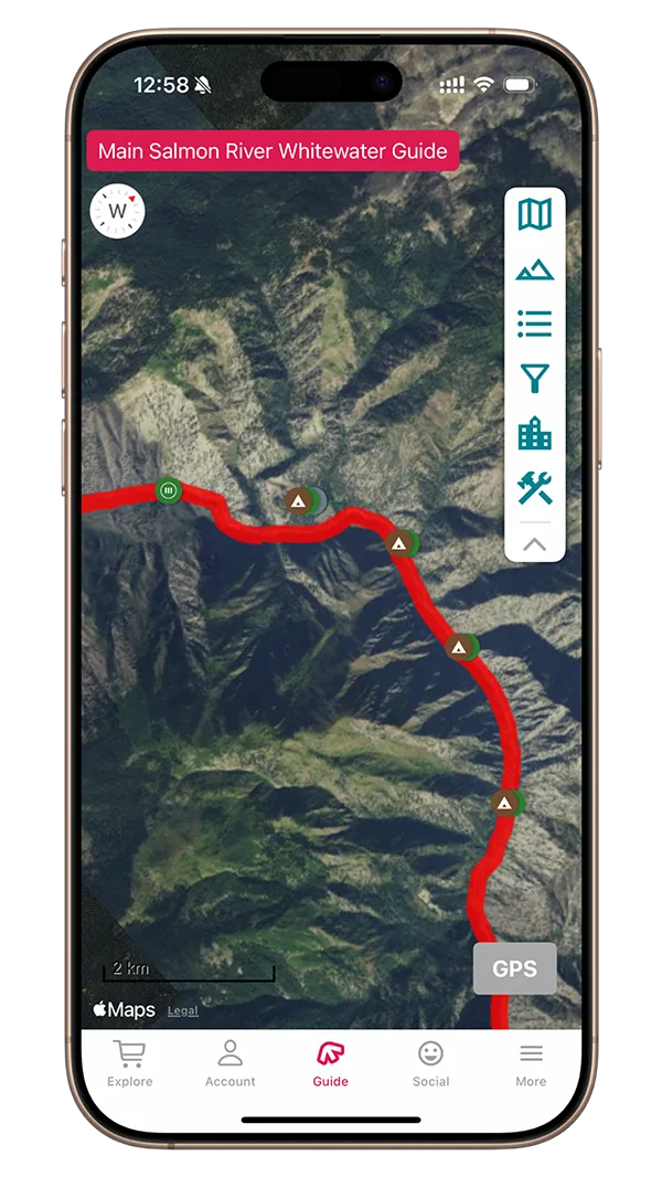
Corn Creek to Carey Creek – Class II & III
81 beautiful miles of Class II and III rapids with beach camping and warm water.
Mile 0 – Corn Creek Boat Ramp:
River Right. This is a large boat ramp and permit administration site shared by rafts and jet boats. Nearby is a campsite, a source of drinking water and pit toilets.
Mile 0.1 – Wheat Creek:
River Right. Just below the put-in ramp is Wheat Creek. This creek represents the eastern boundary of the Frank Church River of No Return Wilderness. The name comes from its proximity to Corn Creek.
Mile 1.4 – Killam Rapid:
Class III. Named for Jack Killam who built a cabin that straddled the trail on the south side of the river above Gunbarrel Rapid. The Killam family lived here in the late 1930’s. Rocks and tricky current provide the first opportunity for inflatable kayakers to swim. A substantial rapid at high flows.
Mile 2.0 – Gunbarrel Rapid:
Class II. At high water this is a difficult rapid. From here to Horse Creek there are low water beaches on the left that are great lunch spots or suitable as small camps.
Mile 2.5 – Lunch Bar Campsite:
River Left. Small sloping sandy campsite with early shade. Gets better at low water. Good first day lunch.
Mile 3.4 – Upper Horse Creek Camp:
River Right. Located upstream of the creek, the camp is in the trees.
Mile 3.6 – Lower Horse Creek Camp:
River Right. Low water bar just below the creek. Difficult landing in small eddy. On the opposite side of the river are the remains of a pack bridge that was condemned and removed in 1970.
Mile 3.6 – Horse Creek Rapid:
Class II. Horse creek comes in on the right and separates the two camps. Originally Big Sheep Creek. A herd of abandoned horses were left here after the demise of two fur trappers. Seeing an opportunity to acquire the fur harvest, one trapper killed the other but was captured and hung before getting away. Another possible origin of the name comes from activities of the Gattin brothers. They were known horse thieves who rebranded horses at their ranch on Big Sheep Creek and resold them in Montana.
Mile 3.6 – Bridge Piling Camp:
River Left. A mid-sized campsite that’s best at low water.
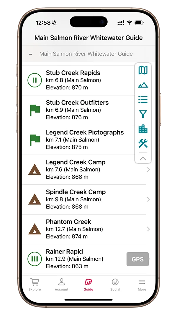
Mile 4.2 – Stub Creek Rapids:
Class II. Read and run at normal and low flows. Large waves at high water.
Mile 4.3 – Stub Creek Outfitters:
River Left. No camping. Cabins are used by a fishing outfitter.
Mile 4.4 – Legend Creek Pictographs:
River Right. Can be a tricky but short walk to the pictographs which are located on the wall towards the back of the landing area.
Mile 4.7 – Legend Creek Camp
River right. Small beach camp with an easy landing. The pictograph site is accesible from here by walking upstream about 500 yards. Be cautious of poisen ivy.
Mile 6.1 – Spindle Creek Camp:
River Right. Medium Group Size. Sloped beach leads up to some tent sites on the bench above. Stone ruins can be found nearby on the bench from settlers in the 50’s.
Mile 7.9 – Phantom Camp:
River Right. As the water drops this beach camp grows. Two beach areas are separated by some rocks. Upper beach is bigger. This is just above Rainer Rapid.
Mile 8.05 – Ranier Rapid:
Class III. Large, fun waves make this a great end-of-the day rapid. It can be challenging for inflatable kayaks. When in doubt, keep paddling!
Mile 8.6 – Alder Creek Camp:
River Left. A comfortable low water camp, opposite Alder Creek. This is a reservable camp. This is the first reservable camp on the Main and is designated as Large.
Mile 9.05 – Alder Creek Rapid:
Class II. This read and run rapid has small, splashy waves.
Mile 10.0 – Otter Beach:
River Left. This is a small, low water camp at the end of a stretch of slow water. There’s shade here.
Mile 10.2 – Fawn Creek Camp:
River Right. Shaded camp located up on the bench.
Mile 10.6 – Upper Lantz:
River Right. Camp among the trees on the bench. Landing is a rocky bar upstream of the creek. Better access at medium to high water. Keep an eye out for golden eagles in the area.
Mile 10.7 – # Creek Camp:
River Right. Camp among the trees on the bench. Landing is a rocky bar upstream of the creek. Better access at medium to high water. Keep an eye out for golden eagles in the area.
Mile 11.1 – Lower Lantz Bar:
River Right. Large bar above a sandy beach. Located just above Lantz Rapid.
Mile 11.3 – Lantz Rapid:
Class II+. Enter right of center and then work back left to avoid the rocks and wall jutting out from the river right bank. At certain water flows there can be a large center hole that is troublesome for smaller rafts and kayaks. Avoid this by going to the right of it.
Mile 11.3 – Tag Creek Camp:
River Left. Immediately below the rapid on the left. Okay at high water. Rocky climb at low water. Comfortable camp once you get there. In the trees.
Mile 11.3 – Eddy Beach:
River Right. A small, low water beach.
Mile 11.7 – Disappointment Creek:
River Left. Like the miners before you, camp here and you might be. The camp is on a high bench downstream from the creek. In summer heat, it can be a strenuous climb. The nearby feeder streams, named Dismal, Starvation, Hungry and Steep hint at discomfort.
Mile 12.9 – Upper Devil’s Teeth:
River Right. Low water pebble beach camp just above the rapid. Pay attention as this camp has been missed many times. This is a small-medium reservable camp.
Mile 12.9 – Devil’s Teeth Rapid:
Class III. The run is between the “molars”. Lots of inflatable kayakers swim here.
Mile 13.0 – Lower Devil’s Teeth:
River Left. Large pleasant camp. You can scramble downstream about 100 yards to a pictograph site. This is a large reservable camp.
Mile 13.3 – Devil’s Teeth Pictographs:
River Left. Pictographs on the rock face.
Mile 14.3 – Overhang Camp:
River Right. Appropriately named, you can spot this camp from far up river. Sometimes called Hangover Camp. This is a small, low water camp.
Mile 14.7 – Elkhorn:
River Right. Large, pretty camp up on the bank.
Mile 15.5 – Chamberlain Creek Camp:
River Left. Small camp that’s here at low flows. Catch the eddy just upstream of the creek. There is a trail on the downstream side of the creek that goes to Chamberlain Basin. The headwaters of Big Creek, which drains to the Middle Fork of the Salmon, is at Chamberlain Basin.
Mile 15.9 – CHUCKAR Beach:
River Right. A medium sized low-water beach camp.
Mile – Class II rapid
Class II. Boulder garden at low flows.
Mile 17.0 – Blackadar Camp:
River Right. This camp is located on a high bench in a Ponderosa grove. It is named after Dr. Walt Blackadar of Salmon who was well known for making a solo trip in Alaska down the Alsek River in 1971. The trip was featured in a Sports Illustrated article. Blackadar died while kayaking the South Fork of the Payette in 1978. This is a large, reservable camp.
Mile 17.2 – Motor Camp:
River Left. This is primarily a low water camp just above a right hand bend in the river. Keep your eye out for the engine in the center of camp. Designated as a large, reservable camp.
Mile 17.9 – # Camp:
River Right. Low water camp about 1/4 mile downstream from the creek and around the bend in the river. Original sites of the Guth cabins. This is a small-medium reservable camp.
Mile – River of No Return Lodge
River Right. This is the River of No Return Lodge. Groups can reserve to stay here by calling 208-851-5555
Mile – Upper Corey Bar
River Right. A large, practically shaded camp that was burned in 2000. Landing is at the upstream end of the bar before the river begins to bend left. This camp is well separated from the downstream site.
Mile – Lower Corey Bar
River Right. Fast landing here at higher flows. Beach comes out at lower water.
Mile – Pebble Beach
River Left. Small low water beach
Mile 20.4 – Start of Black Canyon:
First glimpse of the Idaho Batholith and Black Canyon. The Salmon river courses through this huge mass of granite that extends 250 miles north and south and 90 miles across the center of Idaho. The purpose of the 1935 National Geographic Expedition was to study the features of the Batholith.
Mile 20.4 – Arctic Creek Lodge:
This is one of the locations the Army Corp of Engineers had identified as a potential dam site in the canyon. Designation of the Salmon as a Wild & Scenic river in 1980 eliminated the threat of future dams. The Artic Creek cabins are under Forest Service Permit.
Mile 20.4 – Former Salmon Falls:
Class I. This rapid no longer exists as it is now buried under the pool caused by Black Creek Rapid, just downstream. When it was a rapid, Salmon Falls featured large holes on the left, with a small slot for rafts right of center that was an exciting drop.
Mile 20.9 – Black Creek Rapid:
Class IV. There was little excitement here until a debris flow from Black Creek in April 2011 created this rapid and at the same time submerged Salmon Falls upstream. Scout from the left bank. Depending on water level, this rapid has several routes.
Mile 21.4 – Black Canyon Beach:
River Right. Small campsite with an easy beach landing. Nice views looking back upstream at Black Canyon.
Mile 21.9 – Sabe Creek:
River Right. One of the prettiest creeks on the river.
Mile 22.5 – Hot Tub Hot Springs:
River Left. No camping or stopping for lunch. This is one of the best hotsprings in Idaho. Enjoy.
Mile 22.7 – Sunny Bar Camp
River Right. Rocky landing. Medium carry to a shaded ponderosa grove on a bench. At low water, you may still be able to access the hotsprings from this camp.
Mile 23.0 – Barth Hot Springs:
River Left. At lower flows look for inscriptions. There are at least 6 rocks with names and dates. Guleke charged about $1,000 for a trip down the salmon. That price covered passage, the cost of the boat and the long, arduous trip back home to Salmon City.
Mile 23.1 – Hot Spring Camp:
River Left. Around the corner from the hot springs. This is a good camp but strong current and rocks can make the landing difficult.
Mile 23.8 – Sandy Hole Camp:
River Right. A good lunch spot after a stop at the hot springs. This is a small camp.
Mile 24.2 – Poor Bar:
River Left. A good high water camp but, from its name probably not a good place for prospecting. Downstream and on the other side of the river from Nixon Creek. USFS has it listed to fit 30 people.
Mile 24.8 – Bruin Bar:
River Left. Excellent camp with difficult landing at higher flows. On early season trips, stop up-stream to make sure you’ll be able to get in. This is designated as a large, reservable camp.
Mile 25.8 – Hancock Rapid:
Class II. There are rapids on both the Middle Fork and the Main Salmon named for Monroe Hancock, a skilled boater who ran sweep rigs for Captain Guleke. Along with John Cunningham, he captained the 1935 National Geographic trip down the Main Salmon. After leaving Bear Bar, Hancock built another cabin about 20 miles downstream of Reed Creek. More action is available if you stick towards the right. Towards the bottom right there is a large kayak eating hole.
Mile 25.9 – Hancock Camp:
River Left. Immediately below the rapid, but at higher flows you’ll need to be working left very early to catch the landing. This is a small-medium reservable camp.
Mile 26.5 – Wake Up Rapid:
Class II. Large waves lurk in here. Many folks now call this Maisie’s Rapids
Mile 27.1 – Dillinger Creek:
River Left. The creek entering on the left is Dillinger Creek. Supposedly the first prospector to discover gold on Oregon’s Rogue River.
Mile 29.2 – Idaho Centennial Trail:
River Right.
Mile 29.5 – Magpie Camp:
River Left. Large, popular camp that burned in a 2023 wildfire.
Mile 30.9 – Hida Creek Rapid:
Class II. Hida Creek Rapid is a read-and-run rapid.
Mile – Hida Creek Camp
River Left. A low water camp that can accommodate a small sized group. there are tent sites in the boulders as well as the beach. The creek flashed in 2024.
Mile 32.2 – Andy the Russian Rapid:
Class II. This rapid comes at the confluence of Bargamin Creek. Andy Strauss had a cabin upstream of here about a mile. This rapid has very large waves at high water. At smaller flows it’s read and run.
Mile 32.0 – Bargamin Camp:
River Right. This is a big camp, located about 50 yards below the creek. The camping sits on a high water bench, with a small beach at low water. Good campsite with hiking opportunities. If you’re camping here, it’s an easy hike to scout Bailey. Good trail up Bargamin. The creek is also known as the “Little Salmon”. From its headwaters, Bergamin drains south to the Salmon River while Running Creek drains north to the Selway.
Mile 32.6 – Bailey Rapid:
Class III. Fun holes but pay attention as you can turn over here.
Mile 33.2 – Bailey Bar:
River Right. Low water camp with a nice beach. Popular lunch spot. This is a small-medium reservable camp.
Mile 33.4 – Boy Scout Rock:
Class II. The story goes that a large group of Boy Scouts in inflatable kayaks had back to back to back to back (you get the picture) flips and wraps on this rock, all at the same time. At certain flows you can see why this rock could cause big problems. Pay attention here.
Mile – upper Allison Ranch Camp
River Right. The land above the beach is private. This is a sandy beach, USFS has noted it to have lots of poison ivy.
Mile – Allison Ranch Camp
River Right. Large beach. The Allison Ranch jet boat is often parked here.
Mile – Allison Ranch Airstrip
River Right. Allison Ranch Private Airstrip
Mile – Sapp Creek Rapid
Class III. This is a new rapid that formed in 2023.
Mile 34.5 – Five Mile Rapid:
Class III. It can be hard to spot when you enter the rapid but there is a large hole in the center towards the bottom. Enter left and keep working left to avoid this raft flipping feature.
Mile 34.8 – Split Rock Rapid:
Class III. As the water comes down this rapid gets more pronounced with waves. At high water there is a big hole here. Enter right of center and pick your way through. This is a fun one.
Mile 35.1 – Stinker Rapid:
Class II. This is a short, sometimes splashy rapid. Difficult at low flows.
Mile 36.0 – Yellow Pine Bar:
River Right.
Mile – Yellow Pine Bar Airstrip
River Right. Private airstrip.
Mile – Lower Richardson Bar
River Left. Okay camp
Mile 36.9 – Upper Yellow Pine:
River Right. Nice, big camp. Good trail from here to view Mallard. A crank, battery-operated phone system was installed by the Forest Service in the 1940s and operated until the 1980s. The system connected several homesteads and ranches. The wire can be seen at this camp.
Mile 37.03 – Lower Yellow Pine:
River Right. Low water, sandy beach. This is a large, reservable camp.
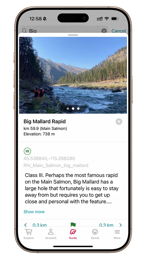
Mile 37.18 – Big Mallard:
Class III. Perhaps the most famous rapid on the Main Salmon, Big Mallard has a large hole that fortunately is easy to stay away from but requires you to get up close and personal with the feature.
Mile 37.44 – Big Mallard Camp:
River Right. Great, large camp just below Mallard Creek. This is a reservable camp.
Mile – Oakie Grogg Camp
River Left. Pull in to a sandy camp below the riffle. This camp was named after Oakie Grogg. He was a moonshiner who, upon leaving his family after a run in with the law, moved to Idaho to continue moonshining. Not a great camp.
Mile – Boiler Hole
River Right. Large group camp. Has a small beach but the easy landing is on a rocky shorline. Camp is on the treed bench. The eponymous boiler, washed downstream from a crashed steam boat driven by Captain Guleke in Big Mallard rapid could be seen years ago in the eddy at low water.
Mile 39.17 – Whitewater Ranch:
River Right. Often used by vehicle campers.
Mile 40.6 – Elk Horn Rapid:
Class III+. Scout from the left. Look for elk antlers on a tree just before the rapid on river left. This is the longest rapid on the river.
Mile – Little Trout Camp
River Left. Small low water camp nestled among the boulders.
Mile 41.91 – Growler Rapid:
Class III. Named to reflect the disposition of a nearby settler, becomes difficult at low flows.
Mile 42.76 – Campbell’s Ferry:
River Left. The original ferry was built by William Campbell around 1890 and provided the only dry means of crossing the river for 50 miles. With the construction of the Three Blaze Trail, prospectors and supplies came down from Dixie and were ferried to connecting trails that lead to Thunder Mountain. During the boom years of 1900-1902, nearly 2,000 people crossed the river. Campbell died in 1901.The ferry operated until 1956 when the bridge was completed.
Mile 42.96 – Frances Zaunmiller Wisner Memorial Pack Bridge
Also known as the Campbell Ferry Bridge, this bridge was completed in 1956.
Mile 43.22 – Jim Moore’s
River Right. Jim Moore was a prospector that settled on this large bar and built all of the structures here, of which, there are many. It’s said his cache of gold is located somewhere on the property and has never been found. To access his property, you can do so by either stopping at Jim Moore’s Camp, just downstream, or at the Campbell Ferry’s Bridge, just upstream.
Mile 43.22 – Easter Egg Beach:
River Left. Many boaters think it’s the bar upstream of the rock outcropping , but Easter Egg is the beach downstream of the rock outcropping. Whichever one you prefer though.
Mile 43.38 – Jim Moore’s Camp:
River Right. A mix of beach and cobble bar. If you plan on camping here be ready to share the beach as folks will stop here on their way to explore nearby Jim Moore’s cabins. This is a small-medium reservable camp.
Mile – Ruff Creek Camp:
River Left. This is a small camp. This is a reservable camp.
Mile 43.9 – 31 Rapid:
Class II. The story goes that this rapid was named for Bob Smith, an outfitter, after a phenomenal day of catching steelhead in the pool upstream. Also known as Don’t Lose Me Now Rapid
Mile 44.27 – Whiplash Rapid:
Class III. At high flows this is an enormous rapid (much bigger than Class III) and should be scouted. At normal flows and lower pay attention to keep away from the rock jutting from shore on river right. If you’re camping at Groundhog Bar, which the rapid passes by, pay attention so you don’t miss camp.
Mile 44.3 – Groundhog Bar:
River Right. This is a large camp that is not accessible at high flows. At normal and lower flows, catch the eddy on river right that forms in front of the large rock feature that gives Whiplash Rapid it’s teeth. This is a reservable camp.
Mile 45.5 – Reed Riffle:
Class II. Read and run.
Mile 45.51 – Reed Creek Camp:
River Right. This is a nice camp that has a pretty creek just upstream of it. This is a large, reservable camp.
Mile 45.95 – Lemhi Creek
River Left. This is a good marker for China Bar rapid right around the corner.
Mile – China Bar Lodge
River Left. If you’re looking for a hot shower and flushing toilets, you can rent a room in advance for $160 / night.
Mile 46.33 – China Bar Rapid:
Class II. The river makes an abrupt left hand turn. Stick to the inside left and you’ll be fine. If you aren’t paying attention and get swung to the center there is a large shelf here that can ruin your day.
Mile – Gaines Bar
River Right. Rocky landing with no eddy. Short carry up to a grassy bench. Camping is on the field between the structures. Not a commonly used camp.
Mile 46.79 – Rhett Creek Camp:
River Right. Located just upstream of Rhett Creek, this is a large, exposed camp. Reservable.
Mile 49.17 – Paine Creek:
River Right. Small camp; Reserved camp site. A small sandy beach with an easy landing at the base of a cliff.
Mile – Boise Bar camp
Low water beach campsite that varies greatly year to year.
Mile 50.31 – Boise Bar Rapid:
Class II. An easy rapid except for the very large hole located towards the bottom near right of center. Stay towards the left.
Mile 51.18 – No Man’s Beach
River Right. Small camp with an easy landing. A mix of rocky and sandy beach with an easy landing and no shade make this a little used camp.
Mile 51.51 – Teepee Camp
River Right. This is a small, reservable camp. The grave marker here is for Jack Ranger who drowned crossing the river here in 1928.
Mile 52.73 – Buckskin Bill’s:
River Left. Formally known as Five Mile Bar, this is where Slyvan “Buckskin Bill” Hart called home. There is a small museum here as well as a re-supply shop.
Mile – Five Mile Creek
River Right. Small group. Easy landing on a cobble beach. Grassy campsite amongst some trees providing shade. You can walk up to Buckskin Bill’s from here.
Mile 53.18 – Pebble Beach:
River Left. Pretty camp that is often steep at low water. Some shade at the top of the beach. Small group.
Mile 53.54 – Haynie Bar:
River Left. This is a large camp. Look for the big boulder that sits just on shore as your visual for where to pull over. Tent sites are on the bar just upstream from here. This is a reservable camp.
Mile – Bluebird Hole
Large campsite. Easy landing. Long narrow grassy camp with pines for shade. Pull in before the river bends and the current picks up.
Mile 54.22 – Wilson Bar
River Right. Also known as Jackson Bar, this is a less desirable camp
Mile 54.22 – Wilson Bar Airstrip:
River Right. This airstrip was completed in 1958. This is the only public airstrip within the Main Salmon corridor.
Mile 54.25 – Jackson Bar Riffle:
Class II. Pay attention to the sleeper holes in this riffle.
Mile 54.82 – Ludwig:
Class III. This is the last significant rapid for approximately 21 mile as the “lake” begins shortly after this. Stick left of center at this rapid and avoid the bottom rocks. As you enter, look left to try to spot Three Mile Creek, supposedly named for the distance to the South Fork confluence.
Mile – Mackay Bar Pack Bridge:
This bridge was built in 1935.
Mile 55.6 – Mackay Bar Bridge Camp:
River Right. Trucks are often parked here from the Painter Mine Road. Reservable camp.
Mile 55.86 – Deadman’s Hole:
River Left. Small camp that may get some air traffic from Mackay Bar.
Mile 56.11 – Mackay Bar Airstrip:
River Left. Private airstrip for Mackay Bar Ranch.
Mile 56.38 – Mackay Bar Ranch:
River Left. Available to book. https://mackaybarranch.com/spring-summer-groups/
Mile 56.63 – South Fork Salmon:
River Left. The confluence of the South Fork Salmon is at this point
Mile 56.63 – South Fork Camp:
River Left. This is a cool camp because technically speaking, you’re on the South Fork of the Salmon. Very difficult camp to get to.
Mile 56.73 – South Fork Island:
River Left. This camp is available during low water flows. The camp is at the bottom of the island. Pay attention as you come around the corner so you don’t miss the eddy.
Mile 56.73 – Diversion Tunnel:
River Right. Just as the river makes a sharp bend to the left, you’ll see the end of a tunnel that was blasted out to generate electric power from diverted water. The power was to be used for a mining operation near the mouth of the South Fork. It was never completed and abandoned in the early 1940’s.
Mile 56.87 – Beginning of the Lake:
Not truly a lake, but it might feel like it sometimes. From this point until close to takeout, the river has plenty of flat water and long pools.
Mile – Cove Creek Camp:
River Left. Easy landing at a small beach against a cliff.
Mile – Red Harlan Camp:
River Right. Similar to many unnamed camps in this stretch, this small camp sits atop a steep sandy beach. At lower water, a cobble beach at the upper end offers more options. This camp was named after Henry “Red” Harlan a longtime hermit of the River of No Return.
Mile – Upper Pine Tree Hole
River Left. Small camp that is perched at the top of a steep beach.
Mile – Lower Pine Tree Hole
River Right. Small camp at the top of a steep sandy beach.
Mile – Hungry Bar
River Right. Small reserved sloping beach camp with ample space. Some pine trees at the upper end provide some shade.
Mile 60.81 – Mann Creek Camp:
River Left. This is a reservable camp.
Mile 61.38 – Warren Creek Camp:
River Left. This is a reservable camp.
Mile 61.58 – Swimming Hole:
River Right. Also known as Warren Bar. Reservable camp.
Mile 62.22 – Indian Creek Camp:
River Right. This is a nice camp just downstream of the creek. There’s a trail here that provides a nice, shady hike. Indian Creek Ranch is up the trail.
Mile – James Creek
River Left. Medium camp. Nice sandy beach with a little shade. Camp in a flat grassy field with trees.
Mile 65.09 – Rabbit Creek Camp:
River Left. This is a reservable camp.
Mile – Polly Bemis Ranch:
River Left. The Polly Bemis Ranch is a designated National Historic site.
Mile 66 – Shepp Ranch:
River Right. Private ranch.
Mile 66.21 – Polly Corner:
Class II. The river makes a jarring right turn that creates tricky current
Mile – Alex Meadows
River Right. A nice beach camp for small to medium groups flanked by a few impressive Ponderosa Pines.
Mile 67.83 – Basin Creek Camp:
River Right. No shade, hot.
Mile 68.67 – Whiskey Bob’s Camp:
River Right.
Mile 69.11 – Upper Bull Creek:
River Right. Reservable camp. Hot camp.
Mile 69.24 – Lower Bull Creek:
River Right. Nice sandy beach with a short carry. Large camp, great for big groups. Has a freshwater spring with a small sitting pool. Good hiking out of camp upstream towards Upper Bull, but watch out for Poison Ivy near the creek.
Mile 70.97 – Gold Rush Bar:
River Right. Small beach that changes annually. Landing on a cobble bar. Camping at the top of the sloping beach.
Mile 71.15 – California Creek Camp:
River Left. This is a large, popular camp that features a sprawling beach just downstream from California Creek. This is a reservable camp.
Mile 72.81 – T-Bone Camp:
River Right. This is a low water beach that may have been named for its proximity to Bull Creek. This is a reservable camp.
Mile 73.4 – Maxwell Bar:
River Left. This is a large beach with minimal to no shade. Great camp for kids as there’s a large sand dune to jump off of into the river. This is a reservable camp.
Mile – Upper Sheep Creek
River Right. Medium sized beach with some camping options on the bench as well. Eddy landing below a jumble of boulders. No afternoon shade.
Mile – Middle Sheep Creek
River Right. Large beach campsite upstream from the creek. Easy landing on the cobble beach.
Mile – Sheep Creek Bar
River Right. Large beach camp just below sheep creek. Late afternoon shade.
Mile – Brush Creek
River Left. Small camp nestled at the top of a steep beach. Easy landing with morning shade.
Mile 75.14 – Dried Meat:
Class III. This rapid was blasted with dynamite after a jet boat accident in 1962 that resulted with five people drowning. Today, the rapid has big waves.
Mile – Slide Beach
Small beach camp. Carry up the sloping beach. Has some shade.
Mile 75.86 – Johnson Creek Camp:
River Right. This is a reservable camp.
Mile 77.6 – Long Tom Creek:
River Left. The Long Tom mine was located at the headwaters of this nearby creek. The term “long tom” refers to a combination sluice box and rocker used by miners.
Mile 77.98 – Chittam Rapid:
Class III+. This rapid can be very difficult at high flows. At all flows the run is generally the same, keep moving right from start to finish. At high flows there are large center holes and the bottom left wall can be troublesome. The scout can easily be done from river right.
Mile 78.17 – Vinegar Creek Take Out:
River Left. This is a narrow boat ramp more commonly used by jet boats.
Mile 78.78 – Vinegar Rapid:
Class III. A steep rapid that gets more exciting as the water gets lower. Stay to the right the whole way through for the cleanest line. Keep your eyes out for the large center wave / hole towards the bottom and make sure you get right of it.
Mile 80.5 – Carey Falls:
Class II. Easy to avoid, but if you accidentally go right you’ll find yourself in one of the larger holes on the entire river. Run left to avoid an embarrassing dunk right before takeout.
Mile – Wind River Camp:
River Right. This is a large camp within sight of take out.
Mile 81.01 – Wind River Pack Bridge:
Near completion in 1961, it partially collapsed and wasn’t completed until the following year. A 24 mile trail starts here that goes up and away from the Salmon and then back down towards the river at Sheep Creek. It then follows the trail until Shepp Ranch.
Mile 81.04 – Carey Creek Boat Ramp:
River Left. This is a large boat ramp that can fit up to three groups. During high flows be careful with the current as it is easy to accidentally go around the bend.