Futaleufú
Our data, powered by FarOut: Download the #1 app for paddling the Futaleufú. Guide by Steve Merrow
Chile
Futaleufú paddling Guide
Comprised of clear glacial waters descending from the mountains in Argentina cutting a distinct path through the Chilean Andes, long days on Río Futaleufú can feel like something out of a dream. With snow capped mountains anchoring the skyline, lush forests pushing up tight against the banks, and abundant fish swimming in the clear water, the “Futa” would be worth a visit if it didn’t have whitewater, but, thankfully, it does. In fact, some of the best you will find anywhere on the planet, and it runs everyday of the year.
For many visitors, the Futa will be a trip years in the making. Elite kayakers exploring Chile’s bountiful whitewater stop on the Futa to play in its massive features and test themselves among famous rapids like Throne Room and Terminator. Lifelong rafters have heard legends about the Futa and are eager to experience one of the top raftable rivers on the planet. Travelers who aren’t yet self-sufficient will likely find themselves surrounded by an expert team of local guides, in both rafts and kayaks. Ensuring the journey lives up to expectations, the quality of guiding and emphasis on safety on the Futaleufú is world class. The Futalefú truly has something for all river lovers and is well worth the long trek down to Patagonia.


Quick Note
The data below is lengthy. If you’re looking to get straight to the guidebook, click here.
About this guide
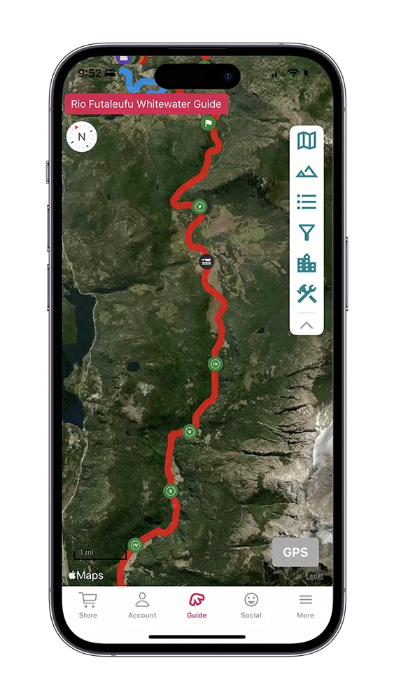
This guide outlines the Futaleufú River from the Put-In at the Chile/Argentina border to below El Macal. This includes many different sections of whitewater ranging from intermediate to expert-level whitewater.
Choosing a Section to Raft
Those traveling to Futaleufú to raft might be overwhelmed with the amount of sections available, and confused by when they can be rafted. The quality of guiding on this river is extremely high. Each company sends out safety kayakers and safety catarafts to ensure any swim in the river is a short one. Guiding on the Futa is considered a big deal in the rafting industry. Both local and international guides train for many years before they get in a boat with guests.
If you have one day, you want to find a company doing Terminator, Bridge to Bridge, and Casa. When combined, this 22 kilometer section is the best day of rafting on the planet. When water levels are too high, companies may be limited to Bridge to Bridge and Casa, or only Bridge to Bridge. Highwater laps on Bridge to Bridge are a thrilling consolation prize when the river is pumping. If the water is low, some of the companies may offer trips to Infierno Canyon. This is a challenging trip to sell because it can be very full on in the Canyon (see description). Some companies may ask you to participate in another rafting trip with them prior to Inferno to gauge paddling and mentality. When the water is too high to run Bridge to Bridge, companies flock to the Las Escalas section.
Rapid Names and Choosing Lines
These rapid descriptions come from years of both rafting and kayaking on the Futaleufú. One of the great aspects of the Futa is the size. That size gives a tremendous amount of variability when choosing lines, making it hard to get bored with so much to explore. The advice listed below, while solid, is not the only way to approach the rapids. Please rely on your own judgment and experience to decide the best way to descend. If you don’t trust your experience, please hire a local guide!
The rapid names used in this guidebook are 95% universal to everyone on the Futaleufú, especially the big ones. Some name deviations occur on Bridge to Bridge below Mundaca and perhaps elsewhere depending on who you are on the water with.
Weather
The primary tourist months for Futaleufú are November through April. With the seasons inverted in the southern Hemisphere, November tends to be the coldest of those months. Things generally start to warm in December and begin cooling down again in April. Proximity to both Antarctica to the south and the dry regions to the north puts Futaleufú in a constant weather flux. When the high pressure system over Antarctica is strong, warm air moves south and gives this region beautiful weather, occasionally reaching the 80s. The ozone layer is thinner here causing the sun’s rays to feel more intense. When the high pressure system weakens over Antarctica, weather moves north towards Futa bringing rain and cold. It is common to see at least moderate amounts of new snowfall on the mountains every month of the year. When planning, prepare for dynamic weather that could be in the 80s for two weeks straight, or rainy in the 50s for the same duration.
Futa River Flows
The course of Río Futaleufú begins in the glacial mountains of Argentina before it is halted by an Argentinian-controlled reservoir, Los Alerces Lake. Realtime data is available on this website: http://www.chfutaleufu.com.ar/serv/hoy.asp. Keep in mind there are a number of tributaries downstream that can increase the volume significantly, especially during the spring and large rain events. The gauge can be difficult to read, so focus on how many tubes are releasing water. The tubes are listed as Caud.G01, Caud.G02, Caud.G03, Caud.G04.
4 Tubes = High Water
3 Tubes = Medium/ High
2 Tubes = Medium/low
1 Tube = Low
If the tributaries are pumping water, assume the higher end of the spectrum. This gauge should be used as one of many resources when deciding which section is right for you on a given day. It should never replace good judgment and the advice of boaters experienced on this river.
In a perfect world there would be numerous online gauges available on the Futaleufú, but without that resource locals and guiding companies use stick gauges to get an idea. The most common stick gauge is at the public Bridge to Bridge put-in, Chucao Beach. This gauge replaced the more well known “Josh’s Gauge” which still exists, but was snapped in half during 2018 highwater.
Chucao Stick Gauge: Highwater = 70 or greater
Medium = 30 to 69
Low = 30 to -100
How to get to the Futaleufu
Futaleufú is about 1,500 kilometers south of the Chilean Capital City of Santiago. Most visitors will initially fly here and then decide how to progress south. It is typically more expensive to fly into Buenos Aires, Argentina but that option is also worth exploring. If you are planning to rent a car, do so in Chile as the vehicles tend to be better. Before crossing any borders in a rental car, check that you are allowed to do so.
Fly – Ferry – Bus
This the fastest and least painful way to get to Futa. It might not be the best option if you are bringing a kayak as the domestic flight to Puerto Montt may or may not take a kayak. The Ferry to Chaiten definitely will, but the bus from Chaiten to Futaleufú won’t. Hitchhiking to Futa is an option, but it could take a couple days if you are unlucky.
- From SCL airport in Santiago, you can book a short flight to Puerto Montt.
- A short, inexpensive bus ride to Naviera Austral Ferry in Puerto Montt.
- Pre book a ferry to Chaiten here https://navieraustral.cl. This ferry does not run every day! Usually three times per week, departing in the evening and landing in Chaiten in the morning.
- Once in Chaiten, a short, free bus to the main bus terminal.
- There are multiple buses a day to Futaleufú. Locals have ticket priority.
Rental Car – Ferry
With so much to see in Chile, renting a car and traveling at your own pace south is a wonderful option. For kayakers, this is the best way to control your own destiny with boats and river logistics.
- Shuttle to car rental in Santiago
- Rental car south.
- You can decide on putting your car on the Puerto Montt ferry that goes directly to Chaiten https://navieraustral.cl, or use a series of smaller ferries that operate during the day.
- Drive to Futaluefú
Bus – Ferry – Bus
Public transportation in Chile is good. You can book a bus to Chaiten that will take over 15 hours. These buses are double decker and have semi or full camas (beds). Although the cheapest option, for a little more money flying direct to Puerto Montt is a lot faster. You may also find buses that travel through Argentina to Futaleufú. Anticipate that these buses will not carry a kayak.
- Taxi to the bus station in Santiago
- Bus to either the Puerto Montt Ferry or to Chaiten
- Bus from Chaiten to Futaelufú
The town of Futaleufu
When we imagine small towns attracting tourists it’s easy to drift to the image of the “cool” ski resort town that has become corporatized to death. Culture driven communities with long standing locals replaced by strips of expensive shops and hotels. Thankfully, Futaleufú does not fit that model. The town certainly has adapted to the influx of visitors during the summer months. Numerous hostels, rafting companies, and markets are available, but the culture and charm of the community remains intact. Walking the streets you will see houses built in the traditional Patagonian frontier style with chimney smoke rising as people bake fresh bread. More modern buildings like the school and hospital have helped improve the community’s infrastructure as well. While a majority of the 2,000+ residents live in the town, the countryside is littered with farms “campos”, where farmers raise sheep, cows, and horses. These large swaths of land are clearly visible as you explore the area by both road and river.
The people of Futaleufú are welcoming to the visitors of their small town. Chileans, in general, are outgoing, passionate, and genuine, often greeting friends and acquaintances with a kiss on the cheek. While rafting companies and some markets will have English speakers, most people will speak only Spanish. Visitors don’t need to be fluent in Spanish to thrive in Futa, but should make an effort to try. It is surprising how many doors filled with unique and fun opportunities open up in this small town when you engage with the locals and other travelers.
What was once a river enjoyed only by foreigners has transformed over the last two decades. Many local girls and boys are now kayaking and guiding the river, giving the older generation a window into why people travel great distances to see the Futa. This is the hopeful progression of any international river community; visitors with experience arrive, explore, and teach the younger generation how to enjoy the resource in their backyard. The talent of guides and kayakers in Futaleufú has long been world class, and now includes many people who grew up seeing this river every day.
Places to Stay
If you elect to raft or kayak with one of the multi day companies, they will have river side accommodations ready for you when you arrive. The town of Futaleufú will offer the most options for accommodation. From an extremely high end hotel overlooking the town, to rustic hostels, there are plenty of options for visitors. Here are some of our favorites.
Cara Del Indio https://www.caradelindio.cl
Located midway down the Bridge to Bridge section on river right. This is a popular camping destination for kayakers that features bathrooms, a kitchen, and some cabañas as well. You are likely to meet other kayakers here which will make sorting out logistics easier. From here you are about 20-30 minutes from the town of Futaluefú. Cara Del Indio has a small restaurant, but you will want to stock up on food in the town if you are cooking.
Hostal Las Natales: http://hostallasnatalias.info
Located in the town of Futaleufú, this Hostel is owned by a wonderful couple who live in town year round. The hostel is clean, offers a variety of room types, has a large kitchen, and is a great place to meet other travelers and boaters. As kayakers, owners Nate and Nancy are well connected within the community and can give advice on guiding services and kayak rentals.
Our Futaleufú guide has it all: 58 Waypoints | Live, Offline Location | 24 photos
$9.99 – Powered by FarOut
4.8★★★★★ 25K+ Reviews
El Límite – Class II, III & IV+
This Class II-IV section is most commonly utilized by fisherman and boaters looking for a more tranquil section of the Futa. When the river is extremely high, this might be one of the only portions available for the commercial rating companies operating in the valley. If you are rafting, the only reasonable takeout involves running a Class III-IV rapid at the end. Kayakers and other small vessels can elect to end the trip at the bridge, avoiding anything greater than Class III. Although it parallels the road, the river gives outstanding views of snow capped mountains and lush forests.
KM 0.00 – Argentina / Chile Border:
The Futa crosses from Argentina and into Chile at this point. Just half a kilometer downriver is the El Limite Put-In.
KM 0.5 – El Límite Put-In:
River Right. Public access point 500 meters from the Chilean/Argentinian Border.
KM 7.5 – Río Chico Confluence:
River Left. Río Chico enters the Futa here.
KM 7.5 – Riffle/Wave Train:
Class III. At the confluence with Río Chico enjoy fun, splashy waves.
MISSING WAYPOINTS AND DATA
Various rapids and access points are left off this online guide. To get access to all Futa waypoints, photos, and data, purchase the guide for full access on the FarOut app. Your purchase supports our work.
KM 10 – Bridge Rapid:
Class III. Easy to scout from the right or from the road before boating the section. The line is right down the middle and is hardest at low water. Novice paddlers may elect to finish their trip just above this rapid on river right, or run the rapid and take out at the bridge on river left to avoid the more significant rapid in a kilometer, Gelvez.
KM 10.09 – West 919 Highway Bridge:
919 Highway crosses the Futa here at the finish of Bridge Rapid.
KM 11 – Gelvez Rapid:
Class IV. High water class IV, low water Class III. If you want to scout this rapid, do it before getting on the river. There is a trail that leads to a nice overlook, . Be aware everything is much bigger once you are on the water! This rapid feels big but is very straightforward by Futa standards. There are three major holes; top left, bottom left, and bottom right. Start right of center and drive left back towards the middle. If things go awry, the largest pool on the river is waiting for you at the bottom. The take out is at the bottom of this pool.
KM 11.25 – Take Out:
River Left. Directly below Gelvez Rapid is a massive eddy, pool, and large sandy beach on the left. That is the takeout beach. If you encounter gates while driving to the takeout, be sure to leave them exactly how they were.
Infierno Canyon – Class IV & V
Infierno Canyon is the closest section to the town of Futaluefú. “Hell Canyon”, cuts deep into the Andes Mountains, constricting the river into a remarkable stretch of whitewater. While no single rapid in Infierno is in the top five most challenging, the consequences of swimming here makes it Class V. Extremely powerful boils, eddies, seams, and holes make it challenging for swimmers to stay on the surface. The steep walls also make it nearly impossible to climb out of the canyon if something goes wrong. The hardest flow for Infierno is the high end of medium when the holes are big and defined. At high water, Infierno is still hard, but a lot of features start to flush out. Rafting companies operate here infrequently, waiting for low water and stout clients. Features and rapids below can vary a great deal depending on water level so always use your best judgment in the moment. If you have the skills and the water levels are right, Inferno is an amazing section that should not be missed.
Infierno Canyon Put-In, Espolón Bridge:
River Left. The simplest access point for this section is the Espolón bridge in the town of Futaleufú. Rafts can make it the 4.5 Kilometers to the confluence with the Futaleufú at all but very low water. Kayaks can always make it.
KM 13 – Espolón & Futaleufú Confluence:
River Right. Rio Espolón and the Futaleufú River meet here.
KM 14.4 – Gates of the Infierno:
The dramatic entrance to Infierno Canyon. This will be the last calm pool for sometime so take a minute to enjoy the dramatic views! The scout for Entrada is directly ahead on the left.
KM 14.5 – Entrada:
Class IV+. Scout left. The entrance has a green tongue leading into a hydraulic at the top. Below the hydraulic is a powerful wave train that drives into a cliff on river left. Enter right in the green tongue and work towards the center. Punch through the hydraulic in the middle with some power. Once through, work right – aiming to ferry just below a large hole on the right.
KM 14.8 – Wall Shot:
Class V. Scout on the left well above the rapid and scramble along the river. Wall shot creates a very obvious V down the center with a wave train that eventually crashes into the river left wall. There are large, powerful eddies on both sides of the V, making swimming a dangerous option in this rapid.
KM 14.9 – Dance of Angels:
Class IV. If you stay in the middle and keep an eye out for holes, this rapid will feel like a breeze compared to everything else on the section.
KM 16.4 – Dynamite:
Class V. For rafters, the only scout is well above the rapid on the right, and involves a scramble. Kayakers can scout on the left closer to the entrance. If you are driving along the river left road towards the Las Escalas Sector, you can see the rapid from a pullout. The features are way bigger than they appear.
KM 16.7 – Perfect Storm:
Class V. At most flows, the hardest rapid in Infierno Canyon comes at the end. While success in the upstream rapids comes from straightforward power moves, Perfect Storm requires more precise maneuvers to avoid some really big features. With no easy scout, and very little time below Dynamite Rapid, you should rally into this one with some good beta.
KM 18.5 – Haussmann Campground Take-Out:
River Left. If you are taking out rafts, or have a vehicle that cannot handle steep dirt roads consider using the Hausmann campground on river left. This access point and campground is privately owned with a locked gate. The owners are a very nice family who lives in the farm across the street from the gate. Don’t hesitate to stop in and offer to pay for river access.
KM 19.5 – First Bridge Take-Out:
River Right. There are several take-out options for this section. If you are kayaking, the fast and free option is on river right at the first bridge crossing. The road back to Futa requires a solid vehicle that can climb a remarkably steep dirt road. Getting there is rarely the issue, as the steep part is on the way back. If you do not have a solid vehicle consider taking out at Haussmann Campground.
Las Escalas – Class III, IV & V
Often overshadowed by Futa’s two hardest rapids, Zeta and Throne Room, the beauty of Las Escalas does not get the recognition it deserves. To many, Las Escalas is the prettiest section of Rio Futaluefú. The river is not gorged in, allowing boaters to appreciate the lush green forests and snow capped peaks. Due to the rain shadow further downstream the weather is typically better up here. From the put-in, enjoy several kilometers of fast moving clear water with few rapids to speak of. With plenty of stout whitewater on the back half, take your time and enjoy the remarkable beauty on the front.
Las Escalas technically ends at the confluence with Rio Azul, but given the lack of a good take-out option there, most boaters elect to ask for permission to take out on private land or run the Class V Terminator section downstream. This section is packed with tons of action and adds about 10 kilometers of adrenaline-packed, beautiful whitewater to your day.
KM 18.5 – Haussmann Campground River Access:
River Left. If you are putting in rafts, or have a vehicle that cannot handle steep dirt roads consider using the Hausmann campground on river left. This access and campground is privately owned with a locked gate. The owners are a very nice family who lives in the farm across the street from the gate. Don’t hesitate to stop in and offer to pay for river access.
KM 19.5 – First Bridge Access:
River Right. There are several access options for this section. If you are kayaking, the fast and free option is on river right at the first bridge crossing. The road back to Futa requires a solid vehicle that can climb a remarkably steep dirt road. Getting there is rarely the issue, as the steep part is on the way back. If you do not have a solid vehicle consider taking out at Haussmann Campground.
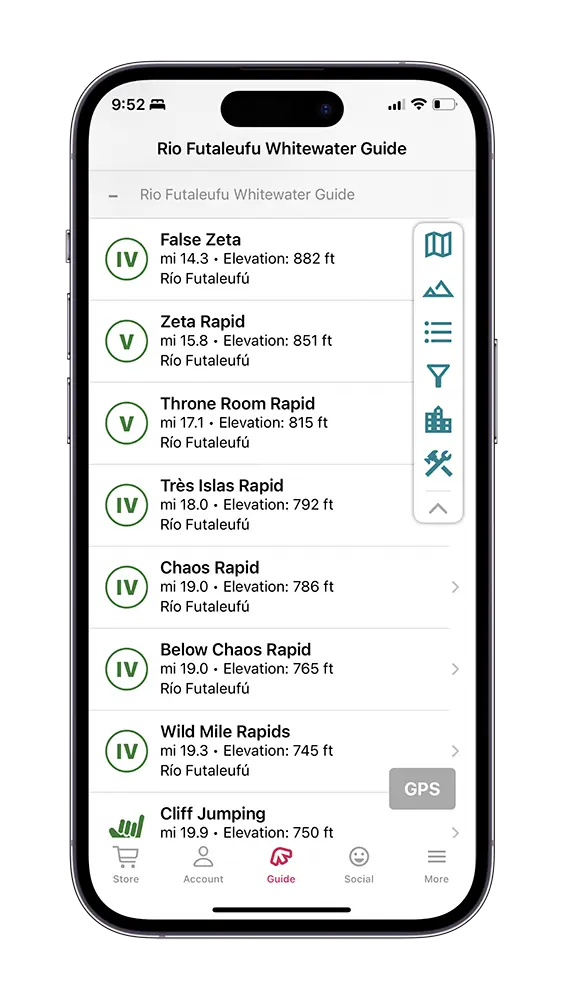
KM 23 – False Zeta Rapid:
Class IV. At high medium/high water, False Zeta has a very stout hole in the left side of the rapid. Use the large boulder in the right center of the rapid as a marker. The hole is in the left center of that left channel. Aim for the right of that boulder as the hole is to the left. If you do elect to go left, stay tight to the boulder or go way left around the outside.
KM 25.5 – Zeta Rapid:
Class V+. Recommended portage. There is an easy scout and portage on the right. Longer scout and portage on the left. Take your time approaching Zeta, keeping along the right shore. Water dependent, this is one of the stoutest and most dangerous rapids on the Futa. It is run by elite kayakers and is rarely rafted. We do not recommend that you run this rapid.
KM 27.5 – Throne Room:
Class V. Easy portage on the left, much harder portage on the right. Throne Room deserves every ounce of its fame and notoriety, combining all the best characteristics of the Futa into one outstanding rapid. The name is derived from the massive rock in the center-right of the rapid, known locally as the Throne. The goal is to start right and get way left of the Throne. With no sneak lines, this is an intimidating rapid!
KM 29.0 – Trés Islas:
Class IV. The start of the “Wild Mile” pay attention to the enormous ledge hole at the center top of the rapid.
KM 30.5 – Chaos:
Class IV. Appropriately named, Chaos Rapid packs a punch. This rapid can be scouted on river left.
KM 30.6 – Below Chaos:
Class IV. Scout right. If you catch the eddy on the right below the first Chaos Rapid, you can walk out onto a rock outcrop to scout. Large boulder top, center left is a great marker. Twenty meters to the right of the boulder is a green tongue that bisects a very wide hydraulic. Carry momentum with you so even if you miss the tongue, you can punch through the hydraulic. Depending on water levels there are small holes and fun waves scattered below. There is a sneak line all the way right that works best at high water.
KM 31 – Wild Mile Continues:
Class III-IV. From here to the Río Azul Confluence, everything is big, fun, read and run waves with some easy to spot holes sprinkled into the mix. No section on the Futa will give you this many exciting, low consequence rapids. At high water, the continuous nature makes it solid Class IV.
KM 32 – Jump Rock:
River right. As you approach a suspension bridge, you will see some cliffs on the right side. These offer great cliff jumping opportunities.
KM 32.3 – Bridge:
Just upstream of the confluence of the Río Azul with the Futalefuf, a bridge passes overhead.
KM 32.5 – Río Azul Confluence:
Confluence with the clear, glacial blue waters of Río Azul. This marks the end of Las Escalas and the beginning of the Terminator Section. On a clear day, you can see Trés Monjas, a beautiful mountain range consisting of 3 spiraling peaks. For people who just want to run the Terminator section, there is a put-in located upstream on the Río Azul.
Terminator – Class III, IV & V
Terminator Section has great scenery, lush forests, and enough challenging, big water lines to keep top boaters satisfied. It also features enough sneak lines to make this a manageable section for Class IV boaters. When combined with the two sections below; Bridge to Bridge and Mas o Menos, this is the best raftable section on the planet. Even with slightly more complicated logistics, make sure Terminator is high on your list when you visit the Futa.
Río Azul Put-In
River Right, Río Azul. With private property lining the banks of the Futaleufú near the confluence of Río Azul, this is the only put-in we can recommend. Turn off the main road here (Google Map link), drive along the Azul river and turn left the first chance you get. You should pass through a gate and an obvious pull-out, this is your put-in (Google Map link below). Not a bad place to begin, the Azul’s glacial water is cold, clean, and beautiful. This put-in will get you 1.5 kilometers from the confluence.
KM 32.5 – Futa / Río Azul Confluence
If you used the Río Azul Put-In, the river meets the Futa here and marks the beginning of the Terminator Section.
KM 32.55 – Trés Monjas
On a clear day, you can see three spiraling peaks above the river left side of the Futa. “The Three Nuns” are sometimes called the Torres Del Paine of Futaleufú.
KM 32.6 – School House Rapid
Class II. A fun series of boulders, waves, and eddies to play in.
KM 35.5 – Asleep at the Wheel
Class IV. The Terminator Section has a very mellow three kilometer start. Asleep at the Wheel is the first rapid to consider. A big wave train indicates you have arrived at the rapid. In the second half of the wave train, work from the left all the way to the right side of a massive hole hidden by the horizon line.
KM 39.25 – Terminator Wave
There is a high quality surf wave with eddy service on river left several hundred meters above Terminator Rapid. Look for the large rock outcrop on river left as the river turns to the right. The surf wave is just below that outcrop.
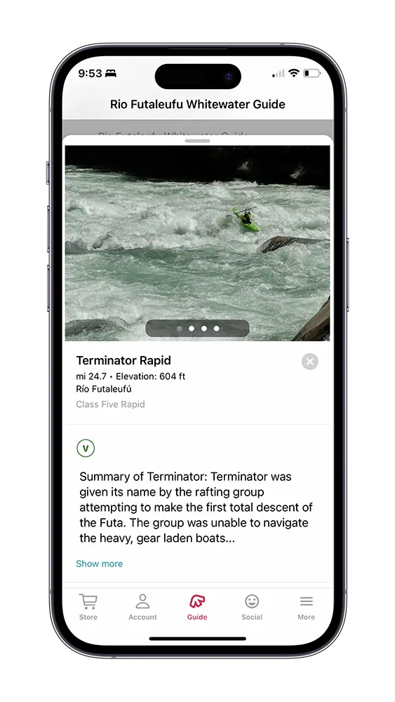
KM 39.25 – Terminator Rapid
Class V. This is a very complex and challenging section of whitewater. Read our in-depth rapid description to learn about the first portage option, entrance rapid, second portage option, and the main rapid itself, Terminator.
KM 40 – Son of Terminator (T2)
Class IV. At low water, this is pretty slow moving with a few easy-to-recognize holes. At medium water, the pace quickens and more holes appear. At high water, the large boulders become massive pour-overs. All these features are easy enough to avoid. The standard line is to work left and exit left center. Immediately start pushing right for Khyber Pass.
KM 40.3 – Khyber Pass
Class IV. There is a large pool above the entrance on river right. From here you can regroup, or find an accessible piece of shoreline to walk down and scout. There is always a sneak line down the right shore for kayaks. The raft line starts right center working towards the middle. Turn back to the right and stay center right. The largest hydraulic is left of center, halfway down.
KM 40.5 – Himalayas
Class IV. Towering, mountainous waves, little consequence, and a pool at the bottom; Himalayas are a universal highlight on the Futa. The center is the most fun at all water levels. If you do feel the need to sneak, options exist on both sides. Medium/High is best, with half a dozen crashing waves stacked on top of each other.
KM 42.5 – Chucao Beach Take-out
River Right. Known locally as Chucao Beach, this is a public access point on river right. Look for a medium sized sandy beach, the take-out is just upstream of that. This is also the location of the stick gauge. Park vehicles up closer to the main road, not on the roundabout.
Bridge to Bridge – Class III & IV+
Bridge to Bridge is the most commonly run section of the Futaleufú both commercially and privately. Super fun, continuous whitewater combined with an easy shuttle makes this a great place to spend a bulk of your time on the Futa. While Bridge to Bridge does not feature anything as challenging as Terminator, at high water the features are massive with very little break between rapids making it solid Class IV+. At medium and low water the pace slows down and the section feels more Class IV.
KM 42.5 – Chucao Beach Put-in:
River Right. Known locally as Chucao Beach, this is a public access point on river right. Look for a medium sized sandy beach, the take-out is just upstream of that. This is also the location of the stick gauge. Park vehicles up closer to the main road, not on the roundabout.
KM 43.4 – Bridge:
This footbridge marks the beginning of the Bridge to Bridge section. Walking across the bridge is worthwhile to scout Entrada or simply to enjoy the view.
KM 43.5 – Entrada:
Class IV+. This rapid is the perfect introduction into the most popular section on the Futa. Wide, fast, and continuous, Entrada is a lot of fun. The continuous nature and consequences downstream mean that staying in your boat is important. For kayakers, there are heaps of waves, boofs, and surfing available as the scope of this rapid is massive and it all goes. For rafts, there are two main lines to consider; a sneak line on the left and the mainline in the center.
KM 44 – Toboggan:
Class IV. At medium and high flows, Entrada and Toboggan feel like one glorious rapid that goes for over a kilometer. Toboggan is a straight channel with a healthy mix of boulders and holes. Enter and stay right of center as the largest holes are on the left and middle. The river constricts at the base, forming a nice wave that can be punched with momentum. Below Toboggan is another several hundred meters of awesome Class III waves on the approach to Pillow.
KM 45 – Pillow:
Class IV. The river is divided by an island into two channels; the class II sneak line on the right, the main line on the left. A large boulder sits on the right side of the main line. Rafts avoid the boulder as both the pillow wave and seam cause flips. Kayaks can do the same, or even boof off the boulder if the water is high enough. Be aware the right side of the rock has a sieve that could pin a kayak. The rapid ends in a calm pool.
KM 45.75 – Magic Carpet:
Class III. An S-Bend, with an incredibly strong eddy on the left. The wave train at the top meets a large boulder on the right and begins turning hard into the left eddy. Cut underneath this boulder and drive hard to the right or the left eddy will pull you in for another lap.
KM 46.5 – Cara del Indio Camp:
River Right. Popular paid campsite on river right.
KM 46.5 – Cara del Indio Rock Formation:
River Left. “Face of the Indian” The near-perfect profile of a face can be seen in a cliff on river left.
KM 46.75 – Cara Del Indio Rapid/Toro:
Class IV. This rapid features a powerful crashing wave train in the left center. These waves are amazing in a kayak, but can flip a raft at most flows. Sneak it on the right if you don’t want to contend with the waves. More rafts would run the main line if Mundaca was not directly below.
KM 47.0 – Mundaca:
Class IV+. Mundaca is the most famous rapid on Bridge to Bridge, and changes a great deal with water level. Whether its towering waves or a crisp boat eating hole, this is the hardest and most fun rapid on the section. Below Cara Del Indio, start heading to the eddies on river right to set up for Mundaca. Those who wish to scout or portage can find a place on the right to walk down. There are a number of lines available, including a sneak on the right, and plenty of fun right down the center.
KM 47.5 – Dos Rocas Dos Hoyas (Pudú):
Class III. Two Rocks, two holes. Start on the right and work your way to the left, avoiding the very obvious holes and rocks on the left and in the center. Finishing left sets you up nicely for the following rapid.
KM 47.75 – Puma:
Class III. Stay left the whole way through this one. There is an enormous ledge hole in the center right.
KM 48. 25 – Last
Wave is a Rock: Class III. At medium/high water this is one of the best wave trains on Bridge to Bridge. As the name indicates, the last wave is actually a huge boulder or a pourover. You can certainly stay in the wave train and avoid the boulder/hole on the left or right. Avoiding the rock at the last moment is much harder in a raft. All the way right avoids everything.
KM – 48.5 – Cazuela:
Class IV. Spanish for stew, this rapid has a little bit of everything and is the final properly challenging rapid on Bridge to Bridge. The super-conservative kayak line is to stay all the way left. The most common line is to start right and quickly work your way back to the center, avoiding a couple of holes further down on the right. The rapid relaxes for a bit and then funnels into some dynamic crashing waves at the bottom. The top right entrance has an awesome surf wave with no eddy service.
KM 49.5 – TiburóN:
Class IV. Tiburón is Spanish for shark. There is a perfect outline of a shark on the bottom left wall where the river turns hard to the right. The shark is easiest to see at low water and unfortunately marks an undercut. The top of this rapid has an awesome surf wave with no eddy service. The conservative line is to start right of center and drive to the right. Don’t worry, there is plenty of time to make this move in all boats. If you decide to explore, be aware of a feisty hole in the left of center close to the top. The eddy to the left of the shark is powerful. If you lost any gear upstream it is probably in this eddy.
KM 51.5 – Second Bridge Take-Out:
River Left. Shortly after Tiburón Rapid, the river makes a hard right turn, bringing the second bridge into view. The clearly visible takeout is located on a large rock outcrop on river left upstream of the bridge. Aim high on the rock and walk up the steeper section. Further down the surging current makes exiting your boat more challenging. This is a commonly used takeout for rafting companies so please be aware of the space they need to carry up boats. If you choose to park at this takeout please do so past the obvious pull outs located past the bridge as the rafting companies need space to load boats and turn around. There are places to pull off a short distance down the road.
Casa – Class III, IV & V
This section has two outstanding rapids and is a notable step up from Bridge to Bridge. Portaging is not really an option, but the road remains close to the river along the left side if you need to walk out for any reason. Class V kayakers will feel very comfortable here. Class IV boaters paddling well with a good crew can also make it down. Rafting companies will start running this section at Medium water.
KM 51.5 -Second Bridge Put-in:
River Left. The put in is upstream of the bridge. These pull outs are used by rafting companies that need space to load boats and turn around. Unless you are dropping people off, please park slightly further down the road on the left or right.
KM 51.6 – Futaleufu Bridge:
This section starts off by passing underneath the bridge.
KM 52.0 –Más o Menos:
Class IV+. The name Más o Menos comes from the Spanish phrase, “more or less.” Meaning everything goes in this rapid, more or less. This rapid has a glorious amount of waves, and clearly the biggest on the Futa when the water is high. It encompasses everything you would expect from a high-volume river and typically ranks high with rafters and kayakers. With a near-infinite amount of lines for kayaks and plenty for rafts, you have some choices.
KM 52.75 – Right Turn Rapid:
Class III. The river makes a sharp right turn after Más o Menos. Stay to the inside, river right, of the turn. The outside has some munchy holes.
KM 53.5 – Casa de Piedra:
Class V. For those combining Bridge to Bridge and potentially Terminator to this section, Casa de Piedra is an incredible rapid to finish the day with. “House Rock” in Spanish features both creaky and high volume must make moves with plenty of holes, boils, and waves to keep you on your toes.
KM 55.5 – Take-Out:
River Left. While driving, it is the first dirt road on the right less than 100 meters beyond the bridge. Stay left as the river comes into view and drive as far downstream as possible. From the river, you will see a very large beach on the left as the river makes a dramatic turn to the right. Catch the eddy on the left as the river turns right. This is the easiest place to unload boats. This take out is used by rafting companies with regularity. There is plenty of space, but please take care not to leave any vehicles in a place that might impede backing up or loading boats.
El Macal – Class III
Macal is a class III section that is often used by kayakers who are preparing themselves for the harder sections above. Everything is read-and-run.
KM 65.5 – Put-in:
River Left. While driving, it is the first dirt road on the right, less than 100 meters past the bridge. This take out is used by rafting companies with regularity. There is plenty of space, but please take care not to leave any vehicles in a place that might impede backing up or loading boats.
Salida:
Class III. Read-and-run rapid.
Z-Turn:
Class III. Read-and-run rapid.
Avalanche:
Class III. Read-and-run rapid.
El Macal:
Class III. Read-and-run rapid.
Take-Out:
Most of the property along the river left shore is private. Ask locals what takeout point is currently okay to be used.