Washington, USA
White Salmon River Rafting Guide
The White Salmon River originates in the Mount Adams Wilderness. It flows for 44 miles before joining the Columbia River. The primary run is made up of exciting, accessible whitewater. If you’re in the area, and you’re a boater, we strongly recommend a visit to this section. At high flows the run is fast and big. At lower flows, the water is beautifully clear and the rapids are still exciting. This stretch is filled with consistent intermediate whitewater, capped of with Husum Falls, the highest commercially rafted waterfall in the United States. In 2011, the Condit Dam was removed, which resulted in the White Salmon River running freely from source to the Columbia River. Check out this awesome video of the demolition of the Condit Dam.
4.8★★★★★ 25K+ Reviews
Rafting the White Salmon? Our White Salmon guide has you covered: 30 waypoints | Live location | 16 photos
$9.99 – Powered by FarOut
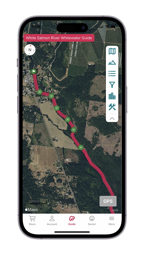
Middle White Salmon – Class II, III & IV
The “Middle” section, typically referred to as simply the White Salmon is the most popular section rafted on the White Salmon.
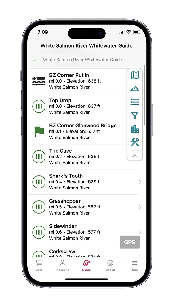
Mile 0 – BZ Corner Put In:
River Right. Put-in on River Right. The Maytag Hole is the large feature in the center of the river at this Put-In. For a little extra action, you can drag your boat upstream to run the Maytag rapid. If not, put in just below this hole.
Mile 0 – Maytag:
Class III. River-wide hole at the Put-In that packs a punch at medium-high water. It is possible to sneak the hole on the right at these flows. At low-medium water, the hole loses much of its power. Look for a break in the left side of the rails as you walk down from BZ. This side trail will bring you above Maytag.
Mile 0.02 – Top Drop:
Class III. Top Drop is a river-wide hole that is most powerful at medium-high water. Run far left or right to avoid the strongest part of the hole. At low-medium water, this rapid is quite easy.
Mile 0.06 – BZ Corner Glenwood Bridge:
Bridge just downstream of Top Drop Rapid.
Mile 0.24 – The Cave:
Class III. A shallow, bumpy rapid pushes you to the right, but work left to avoid an undercut cave on river right. At medium-high water, the cave is at its most dangerous.
Mile 0.36 – Shark’s Tooth:
Class III. The Shark’s Tooth has wrap potential at low water.
Mile 0.49 – Grasshopper:
Class III. Shallow rapid, enter right of center for the least bumpy ride. Watch out for a pourover on the bottom right of this rapid. For kayakers, there is a pin potential here at low water, so be on your toes here.
Mile 0.65 – Sidewinder:
Class III. Sidewinder is a left-of-center entrance, and blast through the center wave if you want. There is a possible surf wave at the bottom left of this rapid.
Mile 0.76 – Corkscrew:
Class III. Enter right at the top of Corkscrew and enjoy a glorious wave train followed by a waterfall on river right.
Mile 0.97 – Waterspout:
Class III. Run the narrow line between a hole on river right and a boil on river left or hit the offset hole straight by working all the way right and pointing to the center.. Downstream of Waterspout is a large log blocking the majority of the river, with a narrow gap on the far right allowing boaters to pass underneath. Above 4 feet, this gap becomes quite small, and anything above 5 would not be passable in a raft.
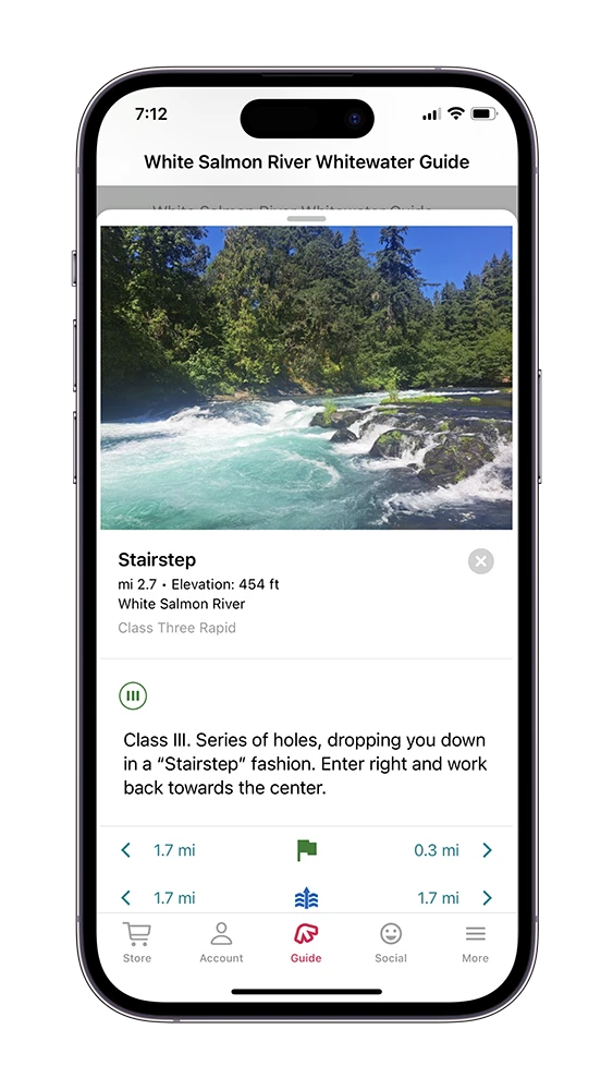
Mile 2.73 – Stairstep:
Class III. Series of holes, dropping you down in a “Stairstep” fashion. Enter right and work back towards the center.
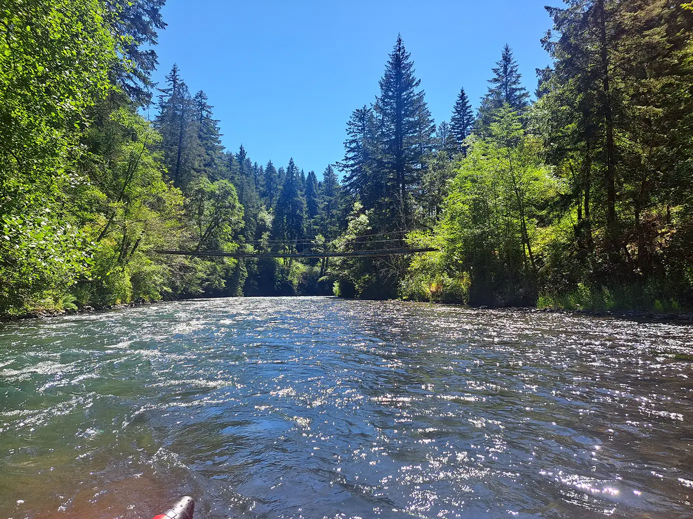
Mile 3.07 – Bridge crossing:
A small bridge crosses the river here.
Learn more about Husum Falls.
Mile 4.47 – Husum Falls: Class IV. Husum Falls is a 10′ drop that goes at most flows but becomes more retentive as flows increase. Portaging here is easy while running the main line is incredibly fun for those who are up for the challenge. Learn more about Husum Falls.
Mile 4.49 – Highway 141 Bridge:
The Highway 141 Bridge passes over the White Salmon River, right as you Put-In. This is a great place to scout Husum Falls if you are setting a shuttle.
Mile 4.48 – Husum Falls Take-Out:
River Left. Take-Out is just below Husum Falls on River Left. A Short walk back to your car parked on river left. Below this point remains a couple of miles of Class II+ whitewater until you reach the former Northwest Lake. This section after Husum Falls is called the “Lower White Salmon”.
Lower White Salmon – Class II & III
The “Lower” section continues on just below Husum Falls, and is considered to be beginner/intermediate.
Mile 4.48 – Below Husum Falls Put-In:
River Left. Put-In is just below Husum Falls on River Left. There is a parking lot just upstream on river right. Below this point are a few miles of Class II+ whitewater until you reach Northwest Lake. This section after Husum Falls is called the “Lower White Salmon”.
Mile 4.49 – Highway 141 Bridge:
The Highway 141 Bridge passes over the White Salmon River, right as you Put-In. This is a great place to scout Husum Falls as you are setting a shuttle.
Mile 4.59 – Husum Street Bridge:
The Husum Street Bridge passes over the White Salmon River just below the Highway 141 Bridge. If you pass this bridge, the next easy Take-out is Northwest Park.
Mile 4.6 – Rattlesnake Rapid:
Class III. Your quintessential “Blow It Up” Rapid. Get momentum, and hit the wave straight. This is the hardest rapid of the Lower White salmon, and below this point are numerous scattered unnamed Class II rapids. It’s a flippy rapid, and can surf an empty boat, but there aren’t many consequences here.
Mile 7.38 – Northwestern Lake Bridge:
The Northwestern Lake Bridge Passes over the Lower White Salmon, right before Take-Out on River Right.
Mile 7.39 – Northwest Park Take-Out:
River Right. After running the Lower White Salmon, Take-Out on river right at Northwest Park, or continue on downstream.
Lower Lower White Salmon – Class II, III, & V
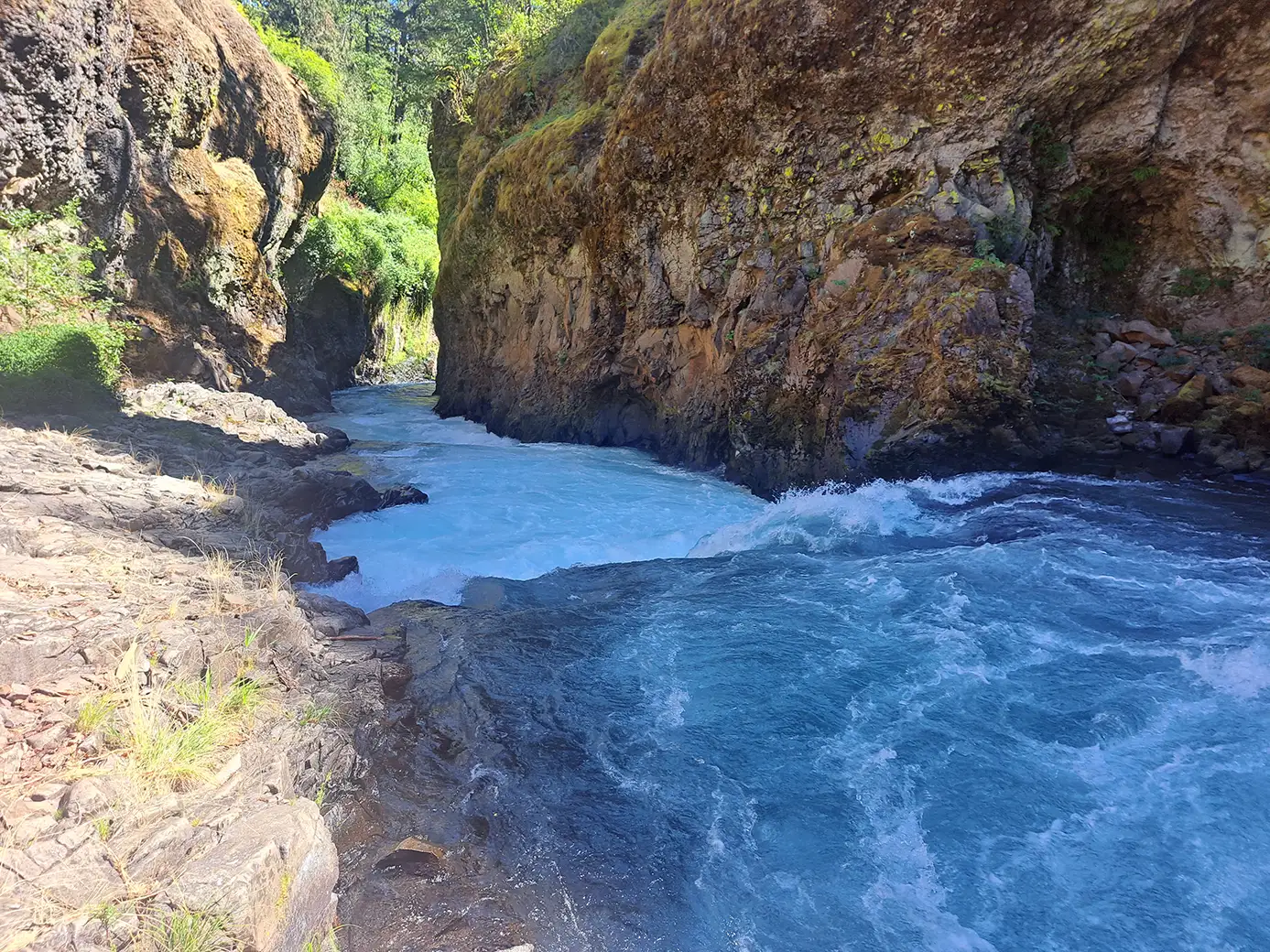
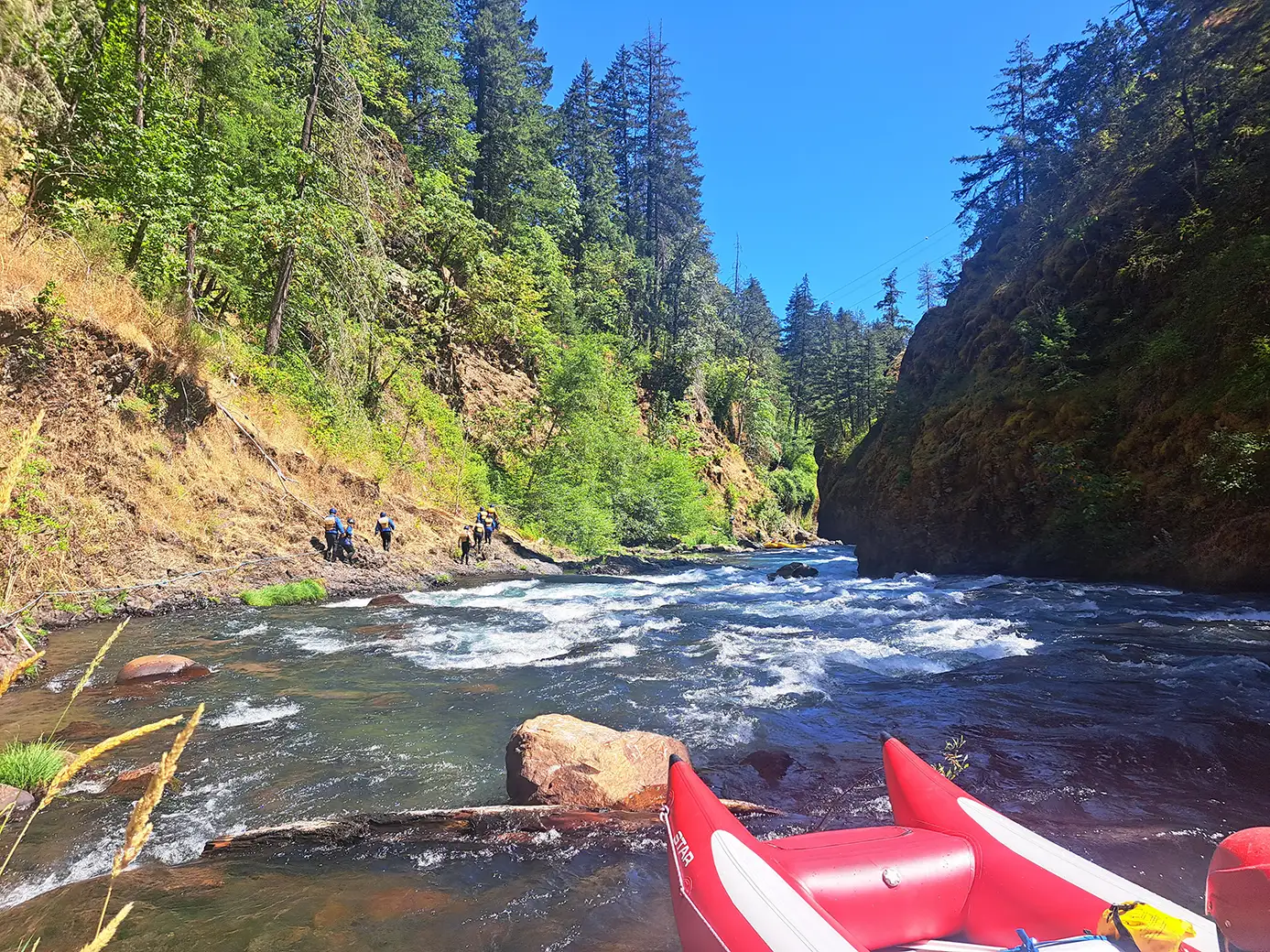
The “Lower Lower” or “Bottom” is the section below Northwest Park. The White Salmon River constricts into a very narrow gorge called “The Narrows”. Be advised there is a Class V known as Steelhead Falls, so be on your toes if you continue on past Northwest Park. This stretch takes you all the way to the confluence with the Columbia River. This section was submerged under Northwest Lake for nearly 100 years until the Condit Dam was removed in 2011. The recreational and environmental benefits of this dam removal have become a landmark example used to promote dam removal around the Northwest.
Mile 7.39 – Northwest Park Put-In:
River Right. The Lower Lower White Salmon begins at Northwest Park.This is a cool stretch, as it takes you through the old site of the Condit Dam, which was removed in 2011. It’s mostly intermediate, but there is one Class V with an easy portage.
Mile 8.86 – Little Buck Creek Waterfall:
Mile 8.86 – Little Buck Creek Waterfall: River Right. Shortly after Put-in, a series of two small but beautiful waterfalls enter the White Salmon on river right. The first of these is Little Buck Creek, which you can park your boat under and take a quick rinse.
Mile 8.91 – Spring Creek Waterfall:
River Right. The second waterfall, just downstream is called Spring Creek Waterfall.
Mile 9.12 – Former Condit Dam Site
River Left. This is the site of the old Condit Dam, which was removed in 2011. Check out this awesome video of the dam demolition. On river left, there are some remnants of the dam site you can look at.
Mile 9.83 – Steelhead Falls
Class V. Recommended portage. The river makes a large S-turn, through a boulder garden. When the river turns back to the right, you’ll see a rocky bank on the left. The main feature to avoid is the river-wide hole just downstream of the bend. Learn more about Steelhead Falls.
Mile 10.36 – Old Condit Powerhouse:
Mile 10.36 – Old Condit Powerhouse: River Left. You’ll pass the old Condit Powerhouse on river left (no longer in use). Just downstream is Class III Powerhouse rapid.
Mile 10.4 – Powerhouse Rapid:
Mile 10.4 – Powerhouse Rapid: Class III. The river bends to the right, pushing most of the water into the left channel. Keep working right.
Mile 10.5 – Bridge:
Mile 10.5 – Bridge: Bridge crossing.
Mile 11.04 – Finale:
Mile 11.04 – Finale: Class III. Final rapid of the trip. From here until takeout the river flattens out and is quite mellow.
Mile 12.39- Columbia River Take-Out:
River Left. Takeout is on river left at the confluence.