Shotover
Our data, powered by FarOut: Download the #1 app for paddling the Shotover
New Zealand Whitewater
Shotover paddling guide
The Shotover is a stunning, bright blue river that runs from Lochnagar at its headwaters in the Southern Alps to the iconic Lake Wakatipu in Queenstown. It’s well-known for its gold-mining history, among many other histories; more gold was extracted from the Shotover during its peak mining boom than from any other river except Canada’s Yukon.
There is a lot of whitewater packed into a short stretch, with unparalleled scenery. A trip down this river is a must if you find yourself in Queenstown, NZ.


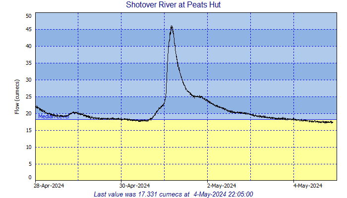
Shotover River Flows
The Shotover has a remarkably wide range of runnable flows. Like all rivers in New Zealand, flow is measured in cumecs (CMS), or cubic meters per second. (1 CMS = ~43 CFS). Flows lower than 5-10 cumecs are extremely low, and anything upward of 60-70 is high. Solid kayakers will put on at flows above 100 CMS, but be ready to scout and know that there’s no cell service and no easy way out of the canyon once you’re in.
How to get to the Shotover
Driving in: Keep in mind that the Skipper’s Road, the only route into the Shotover, is a national historic site– and as such is minimally maintained. The road is unpaved and extremely exposed in many places, with remarkable views of the Southern Alps. There are many blind corners and narrow spots, and regular commercial traffic coming both ways. NOTE: If you’re in a rental vehicle, driving the Skipper’s Road will void any insurance you’ve purchased for the car. Don’t be that guy.
Hitching in: If you’ve only got a rental vehicle, the best option may be to hitch in with a commercial trip. Go Orange runs their trips out of a base in Arthur’s point, and if you’re a small group with only kayaks/packrafts, you may (no guarantees) be able to hitch a ride to Deep Creek with them. Bring the guides a box of beer and be willing to wait if there’s no room on the next trip.
The town of Queenstown
Queenstown is an awesome town, with access to many outdoor activities. Here’s a list of some of our favorites.
- Bike the gondola: If you’re a keen mountain biker, you can rent bikes and buy passes for the Skyline Gondola, which takes riders to the top of a trail system directly above town.
- Earnslaw Ferry/sheep shearing: For an evening out, consider hopping on the Earnslaw, an old historic steamer that still operates on Lake Wakatipu. The ferry takes tourists across the lake to the Walter Peak Station for a fantastic dinner and sheep-shearing demonstration.
- Local hiking:
- Ben Lomond Peak: One of the frequently-hiked peaks right above Queenstown. Great views out over the city, Lake Wakatipu, and the Remarkables range.
- Moonlight Track: This walking track can take you from Arthur’s Point, up into the Moonlight Creek basin above the Shotover and back over Ben Lomond into Queenstown. It also makes a nice out and back from Arthur’s point if you don’t have a shuttle available!
- Routeburn Track: The Routeburn is considered one of the Great Walks and starts at the far northern end of Lake Wakatipu past Glenorchy. You can through-hike the track in a day, if you’re ambitious, or in several– a hike that requires booking a ride on a shuttle bus on the far end. You can also do short out-and-back hikes on the Routeburn, or up the nearby Greenstone, Dart River, or Rees River Tracks.
- Remarkables: The Remarkables, the jagged mountain range that forms the southern skyline of Queenstown, offers some incredible hiking and climbing. From the base of the Remarkables ski field, take a walk up to Lake Alta, a gorgeous, high alpine lake that sits below the biggest peaks. For folks looking for a big day, the Remarkables Grand Traverse is great for anyone comfortable with off-trail scrambling, big exposure, and fourth-class ridge travel. This route takes you over Single Cone and Double Cone, the tallest peaks in the Remarkables, with absolutely stunning views. Ropes/harnesses recommended as a rappel off the south end of the traverse makes the day more straightforward.
Our Shotover guide has you covered: 30 Waypoints | Live Location
4.8★★★★★ 25K+ Reviews
Free – Powered by FarOut


Deep Creek to Arthur’s Point – Class II, III, & IV+
This section is around 16 km long, and boasts a surprisingly large number of rapids.
KM 0.00 – Deep Creek Put-in:
River Left. Deep Creek put-in is a cobbled beach on river left. Be courteous to commercial trips and put in downstream of the jet boat launch. Heads up that getting to the put-in involves driving along Skipper’s Road, which is a notoriously difficulty road to navigate.
KM 0.1 -Deep Creek Confluence:
River Left. Deep Creek joins the Shotover River just downstream of the Deep Creek put-in.
KM 4.3 – Rock Garden Rapid
Class IV. A sticky, river-wide ledge is difficult to see coming and tricky to line up. At most flows, the best place to break through the feature is on the right, however, most of the flow pushes left. Best scouted from river left, well above the drop itself. Consider setting safety on the left.
KM 5.85 – Surprise Rapid:
Class III. This short, unassuming rapid has changed significantly over the years, and has been known to flip/wrap rafts in some of its iterations. If in doubt, scout from the left bank.
KM 9.33 – Chief Section:
Class IV+. Named for Moana Roa Chief Haare; a legendary Shotover guide whose memorial can be found in the beech forest above this section. This short gorge contains several stacked class IV-IV+ rapids that are distinct drops (many with sieve hazards) at low water. It becomes continuous, pushy, and consequential at high water. The rapids in this section change frequently, so they’re always worth a scout if you’re unfamiliar with the Shotover. If you’re feeling conservative, scout the Chief section from the top of the cliffs on river left. Be ready to catch the last-chance scouting eddy above Aftershock; it comes up quickly, especially at high water. Confident boaters can scout as needed between the individual rapids at lower flows.
KM 10.07 – Moonlight Creek Confluence:
River Right. Moonlight Creek is one of the bigger tributaries of the Lower Shotover. A short scramble takes you up to a nice waterfall if Moonlight has enough water in it.
KM 11.93 – Shotover Canyon Swing:
The Shotover Canyon Swing drops in from above in this section, so keep your eyes up and watch for people being pushed off a platform (some blindfolded, some strapped to tricycles) a few hundred feet above river level.
KM 12.27 – Jaws Rapid:
Class IV. A mellow lead-in rapid terminates in Jaws, where a large rock blocks the center and right-hand sides of the river, creating a nasty sieve. There is a good line to the left.
KM 12.61 – Oxenbridge Tunnel Entrance:
Here, half the river runs left down Mother in Law (the natural river channel) and half runs through the Oxenbridge tunnel, which was blasted to divert the river for gold mining. The tunnel becomes too tight to run at ~80 CMS. The entrance can be tricky for rafts; guard rocks on the far right at low flows and wrap potential on the left wall of the tunnel– with a serious sieve hazard for anyone swimming into the Mother-in-Law channel. Scout the entrance from the left, and make sure the tunnel is clear before entering. The tunnel terminates in Cascade Rapid.
KM 12.64 – Mother-in-Law Rapid:
Class IV. Mother-in-Law Rapid is the alternate channel if not running the Oxenbridge tunnel. It’s a longer rapid with a couple of distinct tiers at low water. There are many sieves at low flows, with a particularly nasty one immediately at the top of the rapid against the right wall. Lots of large holes, seams, and laterals at high flows. Scout from above on the left bank.
KM 12.82 – Cascade Rapid:
Class IV. Cascade is a large, curving slide rapid at the exit of the tunnel. Enter center moving right along the wall; avoid the shallower part of the shelf along the left wall. Rapid terminates in an angled hole that easily flips rafts at higher flows. Plenty of room and a big eddy to recover at the bottom. Great photo spot! Watch for jet boats and move aside to let them pass below Cascade. Best scouted before you put on by driving down to the beach from the access point on the west end of the Arthur’s Point bridge.
KM 13.44 – Arthur’s Point Take Out:
River Left. Get boats out of the water above the jet-boat dock just downstream. DO NOT continue downstream without express permission (phone call required) from Shotover Jet! The river gorges up just downstream and jet boat drivers don’t expect non-motorized traffic.