Oregon, USA
Rec Stretch Rogue River Rafting Guide
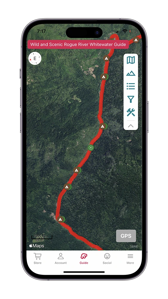
The “Rec Stretch” of the Rogue is the immediate section above the Wild and Scenic corridor of the Rogue River. This section is done either as a mellow full day and shorter or as an add-on to the multi-day portion of the Rogue as it feeds right into it.
This guidebook is for the Rec Stretch section of the Rogue River. Click here for the Wild and Scenic Rogue River guidebook.

Based in Southern Oregon, Indigo Creek Outfitters is our preferred partner for the Rogue river. In addition to the Rogue they operate on the Upper and Lower Klamath and Nugget section of the Rogue. Learn more about Indigo Creek Outfitters.
Rec Stretch & the Wild and Scenic Rogue
Many boaters will put-in on this section to extend their Wild and Scenic Rogue trip or to avoid congestion at the Grave Creek boat launch. Keep in mind, your Wild and Scenic Rogue permit must be picked up the day of your permit launch at the Smullin Visitor Center. Logistically, the simplest way to do this is to drive to the Visitor Center with your equipment, have them check over the required items, issue the permit and then drive to your preferred put-in location and start the trip. If you float to the Visitor Center prior to getting your permit, you may have to hike the required items up to the ranger for them to check.
Rafting the Wild & Scenic Rogue River? Our Rec Stretch + Wild & Scenic Rogue River guide has you covered: 226 waypoints | Live location | 104 photos
$9.99 – Powered by FarOut
4.8★★★★★ 25K+ Reviews
Rec Stretch – Class II
The Rec Stretch is located just upstream of the Wild & Scenic section of the Rogue. This section offers wonderful scenery and numerous Class II rapids to enjoy. It is a much mellower alternative to the Wild & Scenic scenic section, and does not require a permit. Some boaters will add this section to a Wild & Scenic Rogue trip, but it can also be enjoyed as a full day or a half day trip.
Mile 0 – Hog Creek Put-In:
River Right. This can be a busy access point, shared by fishermen, day use and multi-day put-ins. There are other, further access points up river from here, but they are infrequently used for any trip that is going past Grave Creek.
Mile 0.25 – Hog Creek Rapid:
Class II. Avoid the rock at the bottom right. The end of this rapid marks the beginning of Hell Gate Canyon.
Mile 0.77 – Hellgate Canyon Viewpoint:
River Right. This is a big turnout and viewpoint that’s off the highway. This also marks the entrance to Hellgate Canyon.
Mile 1.05 – Dunn Riffle:
Class II. A splashy, read and run.
Mile 1.29 – Rooster Tail:
Class II. Read and run.
Mile 1.56 – Hellgate Bridge:
Mile 1.56 – Hellgate Bridge: Built in 1965, Hellgate bridge spans 350 feet.
Mile 2.31 – Indian Mary Put-In:
River Left. Indian Mary is a popular staging and put-in area for multi-day Rogue trips that cross into the permit section of the Wild and Scenic Rogue that are longer than four nights.
Mile 2.31 – Indian Mary Campground:
River Left. Indian Mary is a large, very nice campground, and there is a boat ramp here. Water and flush toilets are here.
Mile 3.5 – Morrison’s Lodge:
River Left. Morrison’s Lodge offers rafting, fishing, and lodging. Their lodge is located on river left on this large eddy.
Mile 4.91 – Ennis Put-In:
River Left. This is a popular put-in for half-day trips that are taking out above the Wild and Scenic portion of the Rogue.
Mile 4.98 – Ennis Riffle:
Class II. Gentle read and run.
Mile 5.79 – Carpenter’s Island:
Mile 5.79 – Carpenter’s Island: Mid-channel island. Left or right works.
Mile 6.15 – Upper Galice Chute:
Class II. Read and run, this is the first real test for those kayaking.
Mile 6.5 – Lower Galice Chute:
Class II. More read and run.
Mile 6.73 – Galice Put-In:
River Left. Galice is a commonly used put-in to get in some extra miles above the Wild and Scenic Section. There is a $5 day use fee to use this boat ramp. There used to be a restaurant and bar located here which made it a popular stop for rafters and kayakers. On June 8, 2021, this iconic restaurant burned down.
Mile 7.1 – Rocky Riffle:
Class II. Read and run through this right hand turned.
Mile 7.17 – Rocky Gulch Creek:
River Left. The rapids namesake enters the river on the left here.
Mile 9.07 – Chair Riffle:
Class II. Read and run. Supposedly Zane Grey used to fish from a rock that was shaped like a chair at this spot.
Mile 9.22 – Rand River Access:
River Left.
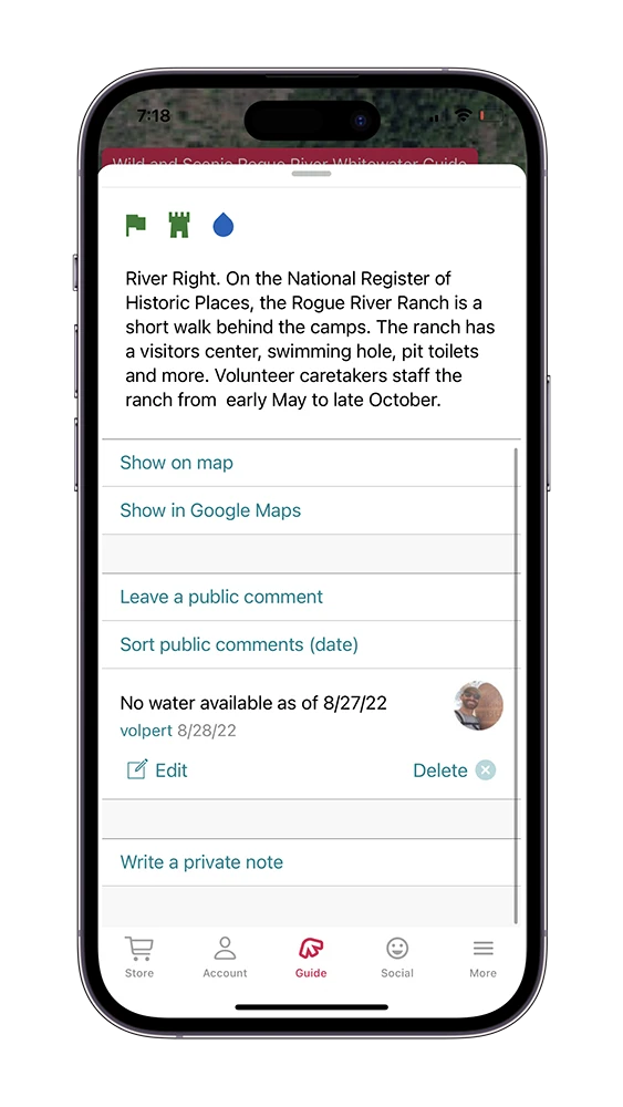
Mile 9.6 – Smullin Visitor Center:
River Left. This is the ranger station where you need to stop the day of your trips launch date to pick up your permit for the Wild and Scenic section of the Rogue if you are continuing past Grave Creek. Learn more about the Smullin Visitor Center.
Mile 9.83 – Island Riffle:
Class II. Take the right channel here. Read and run.
Mile 9.87 – Mark’s Island:
Mile 9.87 – Mark’s Island: Two channels are here, with Island Riffle being the main, right channel.
Mile 10.25 – Almeda Campground:
River Left. Almeda is a reservation only campground that offers a convenient boat ramp. With the Rand Ranger Station close by, this campground and put-in is a good and popular option for multi-day trips that are going through into the Wild and Scenic portion of the Rogue.
Mile 10.27 – Almeda River Access:
River Left. Probably the most popular put-in for the multi-day, Almeda is convenient due to it’s access to the BLM Rand office and this campground acts as a great staging location for trips.
Mile 10.6 – Almeda Riffle:
Class II. A fun read and run.
Mile 11.53 – Jump Rock:
River Right. There are a number of different areas to jump here. Pull in just downstream of this jump rock to access them.
Mile 11.89 – Argo Rapid:
Class II. This rapid isn’t much at higher flows. At low water, pay attention to the rocks here and right around the corner.
Mile 12.12 – Lower Argo:
Class II. Read and run, pay attention to the rocks here at lower flows.
Mile 12.3 – Argo Access:
River Left. If you are doing this section as a half or full day, then it is suggested you take out here, opposed to the downstream Grave Creek Boat Ramp due to congestion issues.
Mile 13.8 – Wooldridge Riffle:
Class II. Read and run. Grave Creek Bridge should come into view from this rapid. This rapid is named after Glen Wooldridge, whom was the first person to take a boat down the Rogue.
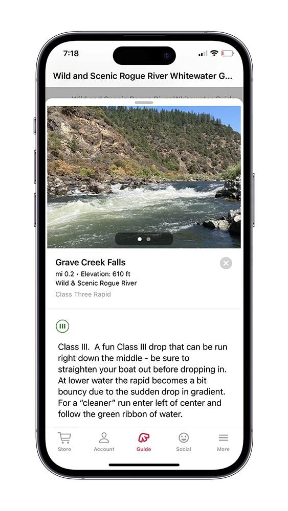
Mile 14.15 – Grave Creek:
River Right. This marks the boundary of the Wild and Scenic section of the Rogue.
Mile 14.15 – Grave Creek Bridge:
Mile 14.15 – Grave Creek Bridge: The Galice Road crosses the river here and leaves the river corridor, heading up Grave Creek on river right. If you have a permit and continuing into the Wild and Scenic section of the Rogue, you won’t see any significant road activity until Foster Bar.
Mile 14.27 – Grave Creek Boat Ramp:
River Right. This is the start of the Wild and Scenic section of the Rogue, which requires a permit to float through. If you do not have a permit, then you must take out here.