Montana, USA
North Fork of the Flathead rafting
A Wild and Scenic River with Glacier National Park on your left for the entire trip, the North Fork of the Flathead delivers clear blue water, steady class II riffles with the occasional class III, and wide-open camping for 2–3 day floats. Add in the views of the Northern Rockies, great fishing, and a stop in Polebridge for fresh baked goods, and you’ve got one of Montana’s classic river trips.
4.8★★★★★ 25K+ Reviews
Rafting the North Fork of the Flathead? Our Flathead guide has you covered: 51 waypoints | Live location | 34 photos
$9.99 – Powered by FarOut
BOrder To Polebridge Section – Class I & II
Mile 0 – Border Access:
River Right. This is a unique river access, as you will put in right at the Canada Border. There is a camp on the bank, and there is an island in the river at most flows. It’s worth walking towards the border, but not crossing as this may result in criminal charges. However, on the US side, there are some cool abandoned outbuildings and a small monument demarcating the US Canada Border.
Throughout this entire stretch, Glacier National Park is on river left, and camping is strictly prohibited, unless you have recevied permisson from the National Park Service. A National Parks Pass is not sufficient, you will need to visit the National Parks Service website to obtain a Wilderness Camping Permit. Flathead National Forest land is on river right, an undesignated camping is permitted along this whole corridor.
Mile 1.1 – Colt’s Creek Confluence
River Right. Colt’s Creek enters the North Fork of the Flathead.
Mile 1.3 – Sage Creek Confluence:
River Left. Sage Creek enters the North Fork of the Flathead.
Mile 4.8 – Pacific NW Trail Crossing
River Right. Thru hikers on the Pacific NW Trail hitchhike across the river here.
Mile 5.4 – Kisenehn Creek Confluence
River Left. Kisenehn Creek enters the North Fork of the Flathead.
Mile 5.8 – Island
Both channels are fine, but, as the river changes, new trees get stuck so be careful to look for new trees as you float through here.
Mile 7.3 – Starvation Creek Confluence
River Left. Starvation Creek enters the North Fork of the Flathead. This confluence offers a deep pool and can offer good fishing.
Mile 8.1 – Trail Creek Confluence
River Right.Trail Creek enters the North Fork of the Flathead from the right-hand side.
Mile 8.1 – Trail Creek Rapids
Class II. Trail Creek Rapids are read-and-run Class II.
Mile 9.2 – Kintla Creek Confluence
River Left. Kintla Creek enters the North Fork of the Flathead.This scenic creek feeds directly from Kintla Lake in Glacier National Park. In the book “Montana Place Names from Alzada to Zortman” the authors place the name from the Kootenai’s meaning sack. “…According to legend, a man had drowned in one of the lakes, and the Kootenai said the lake was like a sack—once you got in, you couldn’t get out.”
Mile 9.2 – Kintla Creek Rapids
Class II. Watch for some shallow bed rock here at low flows. Otherwise, this rapid is read-and-run.
Mile 10 – Lower Kintla Rapids
Class II. Lower Kintla rapids are straightforward Class II rapids.
Mile 13.6 – Ford River Access:
River Right. Ford River Access is great for a two or three day trip. Launch at Ford and float to Blankenship. There are railings to launch into flat water. Park your car in the dirt parking lot downstream.
Throughout this entire stretch, Glacier National Park is on river left, and camping is strictly prohibited, unless you have recevied permisson from the National Park Service. A National Parks Pass is not sufficient, you will need to visit the National Parks Service website to obtain a Wilderness Camping Permit. Flathead National Forest land is on river right, an undesignated camping is permitted along this whole corridor.
Mile 16.5 – Mud Creek Confluence
River Left. Mud Creek enters the North Fork of the Flathead on the left.
Mile 16.6 – Mud Creek Camp:
River Right. This is a great camp featuring a large eddy and a nice cobbled beach.
Mile 17.1 – Whale Creek Confluence:
River Right. Whale Creek joins the Norht Fork of the Flathead here.
Mile 18.2 – Moose Creek Confluence
River Right. Moose Creek enters the North Fork of the Flathead. The river opens up a bit here, offering fantastic views of Glacier National Park.
Mile 21 – ReD MEADOW CREEK Confluence:
River Right. Red Meadow Creek enters the North Fork of the Flathead from the right-hand side.
Mile 21.1 – Red Meadow Camp:
River Right. Red Meadow Creek has a great campsite just downstream of the confluence. There are a couple clearings for tents and good trees to suspend your coolers overnight.
Mile 24.1 – Bowman Creek
River Left. On the left-hand side, Bowman Creek enters the North Fork Flathead.
Mile 24.1 – Polebridge Ranger Station:
River Left. The Polebridge Ranger Station is located on the left, across from the Polebridge River Access. There are bathrooms located here.
It serves as a reminder that river left for this entire section is Glacier National Park.
Mile 24.1 – Polebridge River Access:
River Right. This is a busy access site. Take the right channel around the island to access this take out. Be mindful of the bridge pillars below at high-water as they can cause issues. Park in the parking lot. If you want, walk 1 mile down the road to the town of Polebridge. This town is off the grid and has a great bakery at the Mercantile, a saloon, volleyball courts, and a great atmosphere.
Mile 25 – POLEbridge mercantile
No trip on the North Fork of the Flathead is complete without a trip to Polebridge Mercantile. Their bakery is unbeatable, and they also offer some other groceries if you are in need of a restock.If you get lucky, some weekends feature live music from local bands.
Heads up, if you plan to walk to Polebridge Mercantile, it’s about a one mile walk. It’s worth checking it out if you haven’t seen been there before.
polebridge to blankenship – Class II-III
Mile 24.1 – Polebridge River Access:
River Right. This is a busy access site. Take the right channel around the island to access this take out. Be mindful of the bridge pillars below at high-water as they can cause issues. Park in the parking lot. If you want, walk 1 mile down the road to the town of Polebridge. This town is off the grid and has a great bakery at the Mercantile, a saloon, volleyball courts, and a great atmosphere.
Mile 24.1 –Polebridge Bridge
Polebridge River Access and the Polebridge Ranger Station are separated by Polebridge Bridge. Any exploration past the ranger station will require a National Parks.
Mile 24.9 – Ben Rover Cabin
River Right. Ben Rover Cabin is located near Polebridge River Access. You can rent the cabin from the forest service. It’s a really nice place to stay for night one during a river trip.
Mile 25.6 – North Fork Hostel
River Right. You can stay here during night one of your river trip. It’s a very cool river experience.
Mile 25.6 – Spring Creek Confluence
River Right. You can stay here during night one of your river trip. It’s a very cool river experience.
Mile 33.7 – Coal Creek River Access:
River Right. This is not a busy access but it is a great one. Put in here for a relaxing full day trip to Blankenship Bridge. Coal Creek enters the North Fork of the Flathead here.
Mile 35.5 – Coal Creek Island
A little below Coal Creek River Access is an island. Go either way around this island.
Mile 39.9 – Camas Creek Confluence:
River Left. Camas Creek enters the North Fork of the Flathead. Along this creek is Camas Road, which is alternate entrance into Glacier National Park.
Mile 40.2 –Demers Ridge Hike:
River Right. Beautiful afternoon or morning hike across the road. This is a wonderful place to get some cardio in and stretch your legs.
Mile 40.4 – Camas BRidgE:
Camas Bridge passes overhead here. Camas Road heads into Glacier National Park, and can be a good option during shuttle to avoid driving on the road if it was rough on the drive up.
Mile 40.5 – Lunch Beach:
River Left. Great place to eddy out, have lunch, and fish.
Mile 40.7 – Jump Rock Riffle:
Class II. Read-and-run, but be mindful of some rocks on the far-left which can be easily avoided. There is a cool jump rock on the left.
Mile 40.5 – Jump Rock:
River Right. There is a great jump rock on the right-hand side just below a Class II rapid.
Mile 42 – Upper Big Creek Island:
Go right here if you plan to stay at Upper Big Creek Camp. It is easy to float past here without realizing your error.
Mile 42.2 – Upper Big Creek Camp:
River Right. If you plan to stay at Upper Big Creek Camp, it’s easier to take the right channel around the island.
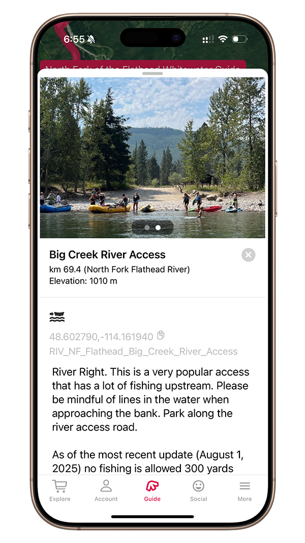
Mile 43.2 – Big Creek River Access:
River Right. This is a very popular access that has a lot of fishing upstream. Please be mindful of lines in the water when approaching the bank. Park along the river access road.
As of the most recent update (August 1, 2025) no fishing is allowed 300 yards upstream or downstream of Big Creek
Mile 43.5 – Big Creek Camp:
River Right. There are numerous campsites along the right-bank here. On a busy weekend, it might take some time to find a good camp, but there are some great ones nestled in the trees.
Mile 44.0 – Island Rapid
Class II+. The North Fork of the Flathead splits around an island. The majority of the water goes through the left channel. There are some fun waves to hit depending on water levels.
Mile 47.0 – GreAt Northern Flats:
River Right. Great Northern Flats is a nice river access, allowing for a half day trip and some good rapids. There are numerous campsites here, and it can be busy during the summer months. For rafts, it’s easiest to find camps downstream of the boat launch, and it will be less busy.
Mile 49.4 – Great Eddy:
River Right. This serene eddy is located in a beautiful, forested section of the North Fork of the Flathead. It is located upstream of the upcoming Class III rapids.
Mile 50.2 – Upper Fool Hen Rapids
Class III. Upper Fool Hen Rapids are read-and-run. There is a fun wave on the bottom left after dodging some rocks and small waves.
Mile 50.6 – Big Rocks Rapid
Class II. In the center of the river are a few large boulders in a pool with good eddies behind them. The river splits into two channels below, take the left channel for a run Class II rapid.
Mile 51.1 – Lower Fool Hen Rapids
Class III. Lower Fool Hen Rapids are a short section of rapids. There are a couple channels to take, both are straightforward, but watch for rocks in the center of the channel.
Mile 53.2 – The Ledge
Class III. This is a very dangerous ledge hole. Stay river left. If you square up, it is runnable, but it is known to recirculate anything that falls into it.
Mile 54.6 – Glacier Rim River Access:
River Right. Glacier Rim River Access is more oft-used as a take-out avoiding a few flatwater miles down to Blankenship or beyond.
Mile 58.3 – North Fork/Middle Fork Confluence
The North Fork of the Middle Fork of the Flathead joins the Middle Fork of the Flathead River.
Mile 58.4 – Blankenship Bridge:
Blankenship Bridge lies upstream of the take-out on river right and left. Pay attention here, as it is possible to wrap on the bridge pylons, which would be quite an interesting way to end your trip.
Mile 58.4 – Blankenship River Access:
River Left. The left-hand side of the Blankenship Access is used by commercial trips, so do be courteous to them.
Mile 58.4 – Blankenship Camp
River Right. Camp anywhere also the beach on river right. This is a very busy spot also used by car campers. It is possible to take out here as well, but the road access to the beach is a bit rough.