Gunnison River – Colorado
Gunnison River Paddling Guide
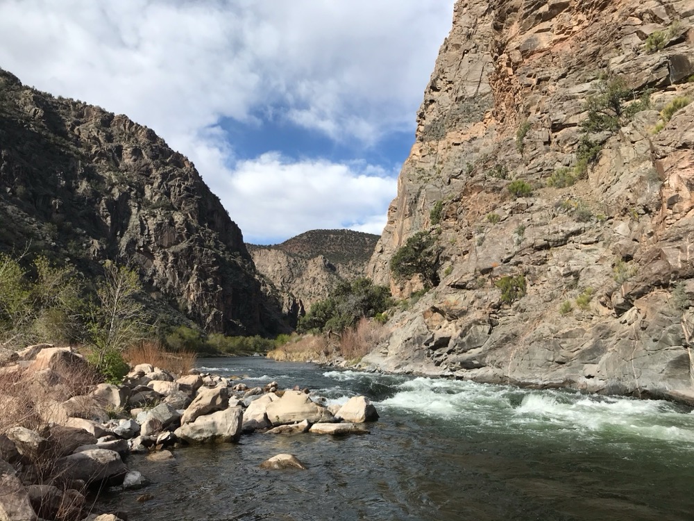
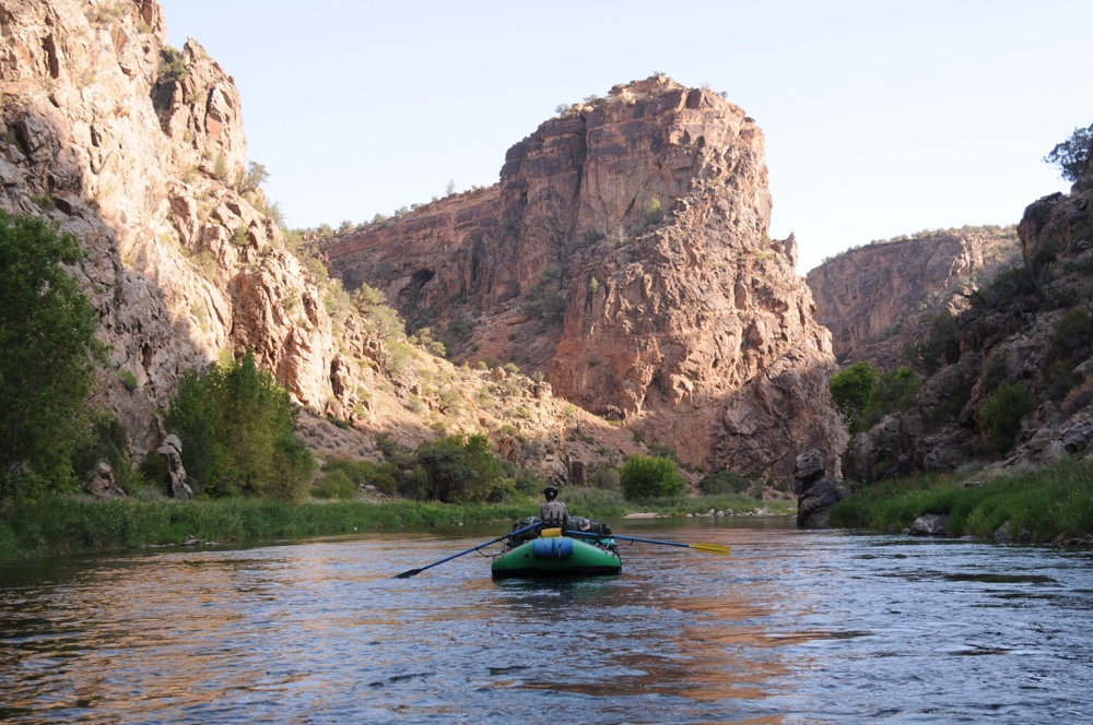
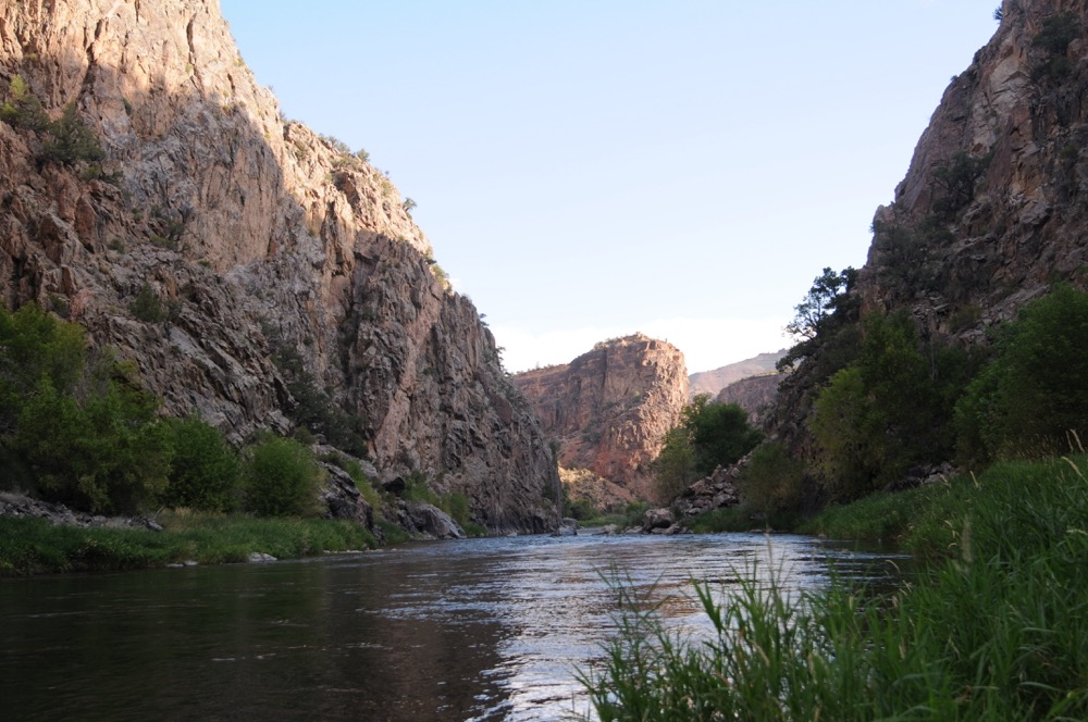
The Gunnison River is a great river trip, featuring a number of fun and tricky rapids. It’s remote, requiring a hike down a 1.5-mile trail which may deter a number of boaters who don’t want to carry all their gear down. However, once you’re on the water, you’ll find the serenity is worth it as you float through this steep canyon. The scenery is spectacular and there are numerous camps, rapids, and hikes on this awesome overnight trip.
This guide was written with help from Wilderness Aware Rafting. They are the premier outfitter located on the Gunnison and other rivers in Colorado. View their Preferred Partners page here.
Getting there
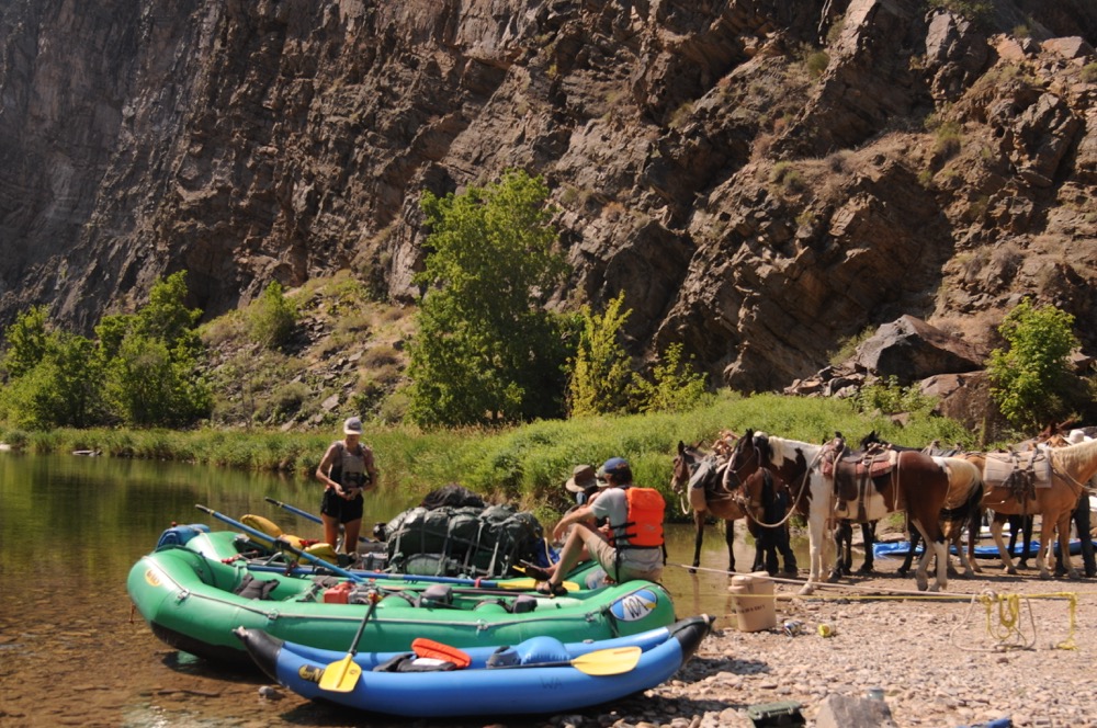
All trips down the Gunnison River require a 1.5 mile hike down the Chukar Trail. Most rafting trips require pack mules to carry all overnight and boating gear. We prefer to work with J & Ray Outfitters for their reliable service and experience in the area. They can be contacted at (970) 323-0115 to confirm availabilty, and calling in advance is advised.
Flows
The Gunnison River is best run in rafts at flows between 800-5000 CFS, with both flows being the extreme low and high-end. Flows can be found by visiting the USGS website and searching for Gunnison River Below Gunnison Tunnel, CO. Flows above 3,000 CFS are rare, and may push some of the rapids on this stretch into Class IV territory.
Wilderness Camping
Important Camping Information, as per BLM regulations. River corridor camping is only allowed in designated-hiker or boater campsites identified on BLM maps and signs. A member of the boating party must register his/her party by signing in at Chukar Boat Launch. For overnight boating parties, only the blue boater campsites can be used, and they must be reserved on the register sheet the day of your party’s launch. No early sign-ins are allowed; camps are available on a first-come, first-served basis. The maximum length of stay at each boater campsite is one night.
Permits
The Gunnison Gorge is a self-permitted trip. Wilderness Permits must be purchased in advance at the Chukar Trailhead. For overnight campers, you’ll be charged $10 per person for one night, and $15 per person for a two-night trip. There is also an option to purchase an annual Day-Use pass for $15/person per year. Maximum group size is 12 guests.
Safety
The Gunnison Gorge is remote, with any rescue being very challenging/impossible throughout the trip. It’s highly recommended to bring your own wrap kit, first aid, and to treat this river with respect.
Rafting the Gunnison? Our Gunnison guide has you covered: 38 waypoints | Live location | 19 photos.
$7.99 – Powered by FarOut
4.8★★★★★ 25K+ Reviews
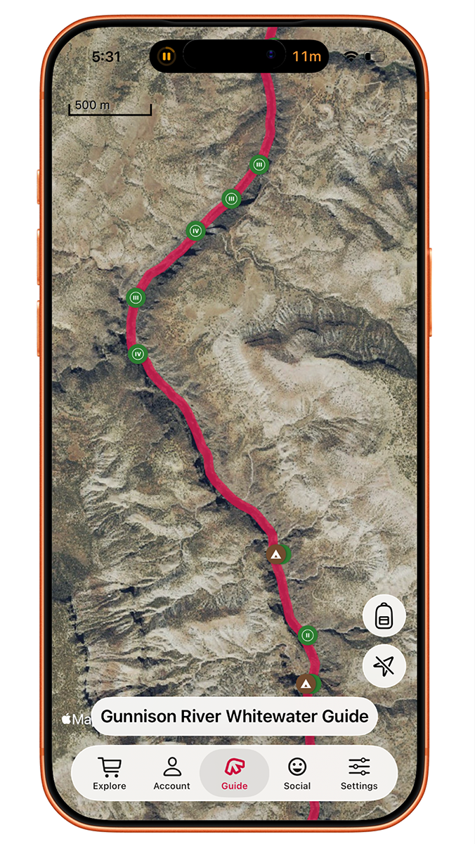
Gunnison Gorge – Chukar to Gunnison Forks – Class II, III & Iv
The Gunnison Gorge stretch starts at the end of the Chukar trail and ends at Gunnison Forks Recreation Site. Covering 14 miles over two days, the Gunnison offers a leisurely pace, offering a chance to worry less about mileage, and focus more on the river itself. Th river mixes calmer sections with a number of Class III-IV throughout this section, and the views are amazing. It’s tough to beat this trip.
Mile 0.0 – Chukar Boat Launch
River Left. After a 1.4 mile walk down to the trail to the Gunnison, you’ll arrive at a nice beach to start prepping your trip. From the BLM website: all gear, including boats, must be carried down the trail to the river. No carts or wheeled devices are allowed in the wilderness. This is strictly enforced.
Mile 0.0 – Chukar Rapid:
Class III. Run left of center. Simple wave train with hole/rock right of center at bottom of some waves.
Mile 0.6 – #2 Big EDDY CAMP
River Right. Medium/ Large Camp early in the Canyon. Watch out for poison ivy.
Mile 1.0 – One MIler Rapid:
Class II. Read-and-run, but stay towards left to avoid a rock/small hole depending on flows.
Mile 1.1 – #3 Otter CAMP
River Right. Medium Camp.
Mile 1.4 – Improvise Rapid:
Class III. After a mellow mile and a half, Improvise Rapid feels like first “real rapid” of trip. You will see small vertical cliff on right and rock slide on the left. Start left-of-center, work your way to the right of center, then read and run at the bottom.
Mile 1.9 – #5 Bobcat Beach CAMP
River Right. Medium Camp.
Mile 2.6 – #7 Middle CAMP
River Left. Small Camp.
Mile 2.8 – Upper Pucker Rapid:
Class II. Read and run, move through narrow slots. Singular moves. Rocks that form slots can become holes at large flows.
Mile 2.9 – Lower Pucker Rapid:
Class II. Read and run, move through narrow slots.
Mile 3.2 – #8 Upper Duncan Camp
River Left. Small Camp.
Mile 4.0 – #12 Buttermilk Camp
River Right. Great sandy beach with shade and the ability to lap the rapid on paco pads or swimming. This is also end of first gorge as the river opens up into Ute Park. Medium Camp
Mile 4.1 – Buttermilk Rapid:
Class III. Buttermilk runs along the cliff wall on the left with a rock/hole left of center about one-third of the way through the rapid. If the rock is not showing the hole is good to go if you’d like to hit it. At high flows this rapid turns into big wave train.
Mile 4.1 – Ute Park
In Ute Park, the canyon opens up a bit and the river widens. There are many shallow areas and it will require some rock dodging, especially at low water. There is hike-in access here in this section, so there will be more fishermen. There are several campsites throughout this area but be mindful of shade, as it can be limited in here. If you are trying to get some hiking in, there is access to the Ute trail, which traverses along the riverside, and you are not cliffed out in the canyon. This area Is about a mile and half before entering Red Canyon, which starts at Red Canyon Rapid.
Mile 4.3 – #13 Cowboy Camp
River Right. Cowboy Camp is a medium-sized camp with good areas of shade. It is the first camp in Ute Park.
Mile 4.4 – #14 Ute #1 Camp
River Left. Large open Camp with minimal shade. Ute #1 offers access to hiking trails river left in Ute Park.
Mile 4.5 – #15 Ute Bluff Camp
River Left. Large Camp in Ute Park.
Mile 4.6 – #16 Ute II Camp
River Left. Large Camp in Ute Park.
Mile 5.7 – #20 Caddis Camp
River Left. Caddis Camp is a small/medium Camp with a rocky beach and great views of the Canyon. It’s the first camp in Red Canyon.
Mile 5.8 – Big Dry Creek Confluence
River Right. Big Dry Creek enters the Gunnison River here. At some point, this creek blew out, creating Red Canyon rapid.
Mile 5.8 – Red Canyon Rapid:
Class III. Red Canyon Rapid is aptly-named by the red-walled canyon as you enter the rapid. The river widens a bit here, so this is a shallower rapid. At the top, work your way through a rock garden, entering either right or left of center, and working to stay in the middle of the main channel. The far right also has a small slot drop for smaller boats.
Mile 6.9 – #21 Baby T Rex Camp
River Right. Baby T Rex camp is medium camp with a sandy beach.
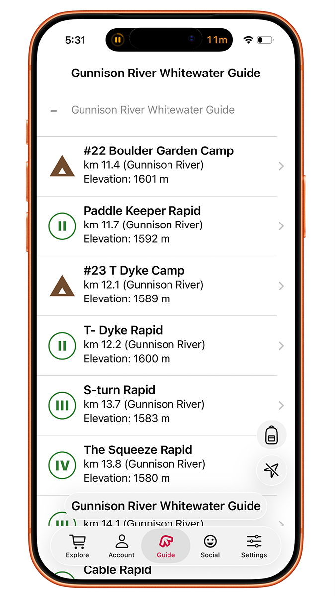
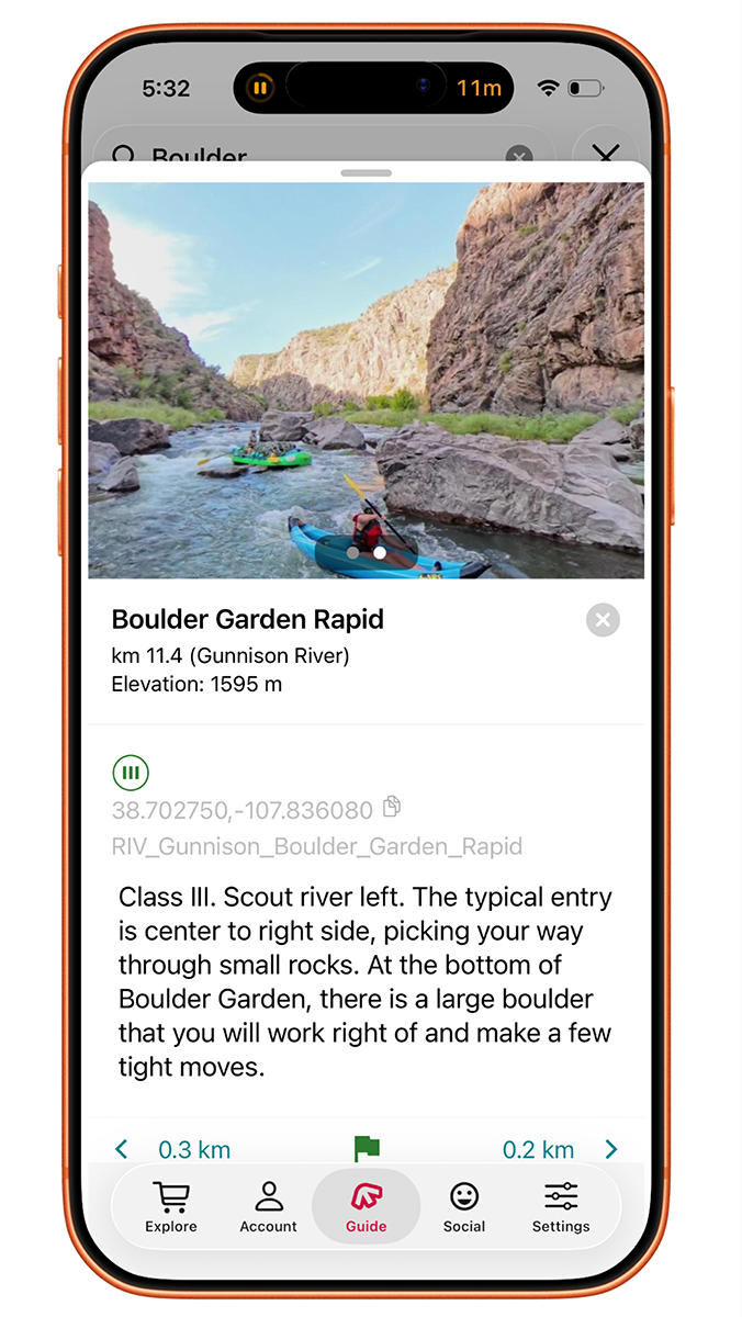
Mile 7.0 – #22 Boulder Garden Camp
River Left. Boulder Garden is a medium-sized camp, located just above Boulder Garden Rapid. It has a rocky beach, and is great to scout Boulder Garden Rapid from the camp.
Mile 7.0 – Boulder Garden Rapid:
Class III. Scout river left. The typical entry is center to right side, picking your way through small rocks. At the bottom of Boulder Garden, there is a large boulder that you will work right of and make a few tight moves.
Mile 7.3 – Paddle Keeper Rapid:
Class II. Read and run. Best run on left.
Mile 7.5 – #23 T Dyke Camp
River Right. T Dyke Camp is a large, sandy beach Camp. It is located right above T Dyke Rapid, which features a small, fun wave train. One important note, it is the last camp that can only be used by boaters on the Gunnison River. All the remaining camps below here can be used by hikers or boaters.
Mile 7.5 – T Dyke Rapid:
Class II. T Dyke Rapid is a read-and-run wave train.
Mile 8.5 – S TURN Rapid:
Class III. S Turn Rapid is a big right-hand turn with the cliff wall on left. There is a large hole/eddy on right side of the rapid, which can be used to stay off the wall.
Mile 8.6 – The Squeeze Rapid:
Class III+/IV. Scout Right. The Squeeze is the hardest move on the Gunnison for large rafts. Enter on the left side of the large rocks at the top, moving slowly to the right, dodging a few guard rocks to make the slot on bottom right. Give decent spacing here, especially at lower flows, as rafts may get stuck here. Keep an eye on your kayakers through this section as well. There is a pool below this rapid to look upstream and set safety.
Mile 8.8 – The Drops Rapid:
Class III. The Drops are the lead in/warm-up for Cable Rapid. There are 3 drops, all mainly read-and-run moving through the center of the river. Good waves here depending on the flow.
Mile 9.2 – Cable Rapid:
Class III/IV. Scout Right. Cable Rapid is another fun rapid on the Gunnison. There is a scout eddy river right, just below a vertical cliff.
The rapid itself has a large cliff wall on the left and many boulders in center of river. The most common entry is right-of-center, passing a large boulder then either moving left to run the “Cliff Line” down a steep drop on cliff wall or moving right to thread the needle though a slot between a middle of the river boulder and large boulder coming off right shore.
Mile 9.3 – Jumpin’ Jack Splash Rapid:
Class III. Jumpin’ Jack Splash has a good lateral wave. Be sure to hit it square as you run left of large boulder and move to the right to avoid holes on the left.
Mile 9.4 – Gate keeper Rapid:
Class II. Gate Keeper is tricky to run clean. A large boulder covers most of the lines here. Large rafts might have to push through here, especially at low flows. Either stay left to squeeze through center rock and cliff wall or pull off the center rock to move through the tighter right line.
Mile 9.5 – Grand Finale Rapid:
Class III. Grand Finale is a two-part rapid, and as you might expect, is the last rapid on the Gunnison Gorge. The top of Grand Finale is read-and-run. The second half of the rapid hides a perfect wrap rock that should be avoided. It is hard to see before it is too late. Work your way through the right side for easiest line or quickly move left before the bottom half of rapid. The Grand Finale gets pretty tricky at lower flows.
Mile 10.0 – Smith Fork
River Right. The Smith Fork enters the Gunnison on the right, making a great lunch spot with a large, rocky beach. It’s a beautiful area and there is hike along side the creek to swimming holes about a half-mile up the creek. Small waterfalls and warm water. Camping is not allowed here.
Mile 13.4 – North Fork of Gunnison River
River Right. Just above the take-out, the North Fork of the Gunnison River enters the Gunnison River on the right-hand side. Stay right, as take-out is located on the right.
Mile 13.4 – Gunnison Forks Day-Use Recreation Site
River Right. Gunnison Forks Day Use Recreation Area in Pleasure Park. Pit toilet. There is a privately-owned Fishing shop known for their breakfast burritos. They also run a shuttle service. Two fishing outfitters are based out of this area.