Idaho, USA
Riggins Section – Salmon River
Famous as a day trip, the Riggins stretch of the Salmon River has awesome rapids, big sandy beaches, and great swimming holes. With tons of camping options, this makes a great overnight as well with simple logistics and beautiful campsites.
This guide was written by Adventure Idaho. Adventure Idaho Rafting is a family-owned and operated outfitter specializing in guided river trips on Idaho’s Salmon and Snake Rivers. Learn more about Adventure Idaho here.
4.8★★★★★ 25K+ Reviews
The Riggin’s stretch is coming soon to FarOut! Please add your name to be added to the interest list and we will email you once it’s released.
Vinegar to Lucille Boat Ramp – Class III+
Mile 0 – Vinegar Boat Ramp
River Left. Optional put-in for the upper section.The upstream ramp is primarily for jetboats. Rafters should use the downstream ramps. This is the end of the road. Next upstream road access is a 10 hour drive away, the start of the Main Salmon. Parking is very limited here. Don’t plan to leave vehicles overnight as space is limited.
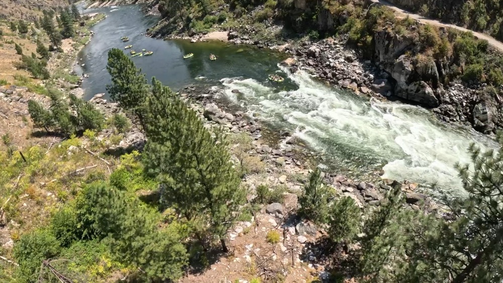
Mile 0.5 – Vinegar Rapids
Class III-IV. Scout Right. Vinegar Rapid washes out at high flows, but gets larger and more technical as the water drops. Large holes in the center. Can be run on the left or right at lower flows.
Mile 2.2 – Carey Falls or Gold Hole Surf Wave
Class II-III. Carey Falls (aka Gold Hole) washes out at high flows. As the river drops, a great surf wave forms on river right. Turns into a dangerous hole as the water drops. The wave/hole is easy to miss by running on the left.
Mile 2.7 – Wind River Pack Bridge:
Near completion in 1961, it partially collapsed and wasn’t completed until the following year. A 24 mile trail starts here that goes up and away from the Salmon and then back down towards the river at Sheep Creek. It then follows the trail until Shepp Ranch.
Mile 2.8 – Carey Creek Boat Ramp
River Left. Carey Creek is the standard take-out for the Main Salmon. Can be used to put-in as well. Restrooms and picnic tables.
Mile 3.7 – Bullion Beach
River Right. Bullion Beach is a sandy beach camp.
Mile 4.2 – Witsher Beach
River Right. Witsher Beach is a sandy beach camp, with a swift current on the upstream side
Mile 6.2 – House Rock
Class II-III. Above 30,000 CFS the large rock in the center forms a house sized hole. Housr Rock Rapid can be run on either side.
Mile 6.8 – Upper Cable Car Hot Springs Beach
River Right. Upper Cable Car Hot Springs Beach is a large, sandy beach camp
Mile 6.9 – Lower Cable Car Hot Springs Beach
River Right. Lower Cable Car Hot Springs Beach is a large, sandy beach camp.
Mile 6.9 – Cable Car Hot Spring
River Right. Cable Car Hot Spring is also known as French Creek Hot Spring or the bat cave. The old mine shaft has hot water inside. Bring a headlight. There is a bath tub in the remains of an old building nearby.
Mile 7.4 – Trail to Cable Car Hot Spring
River Right. Land here for the best access to Cable Car Hot Spring.
Mile 7.5 – Cliff Jumping
River Left. Cliff jumping rocks. Respect private property above high water line here.
Mile 7.6 – SRHAB Camp
River Left. Salmon River High Adventure Base This site has hosted a school, store, post office, and CCC camp. Today it’s owned by Scouting USA (Private).
Mile 8.2 – Upper Smith Canyon
River Right. Upper Smith Canyon is a sandy beach camp.
Mile 8.3 – Lower Smith Canyon
River Right. Lower Smith Canyon is a sandy beach camp.
Mile 9.2 – Couch Wave
Class II. Couch Wave is an easy rapid with a surf wave on the right. It forms around 9,500 to 12,000 CFS or 22,000-29,000 cfs when the Little Salmon River is flowing at least 2,000 CFS. It is likely named the Couch Wave due to being a wide and chill surf wave.
Mile 9.5 – Rock Cave Beach
River Left. Rock Cave Beach is a sandy camo.
Mile 10.4 – Above Elkhorn Rapids
Class II. Small unnamed rapids, a fin shaped wrap rock comes out at very low flows in the center of the river.
Mile 10.6 – Upper Elkhorn
River Left. All of the Elkhorn beaches are large and popular beach camps. Expect to share with other groups during the summer but there is plenty of room.
Mile 10.8 – Middle Elkhorn
RIver Left. The second Elkhorn Camp has an outhouse found near the road. It’s also popular, so you might have neighbors here.
Mile 11.1 – Lower Elkhorn
River Left. Lower Elkhorn is the last of 3 Elkhorn camps. Like the others, it is large, sandy, and popular.
Mile 11.3 – Below Elkhorn Rapids
Class II. Rapids start to pick up here after the large elkhorn beaches. Easy to read and run.
Mile 11.6 – Chamberlain Gulch
River Right. Chamberlain Gulch is a sandy beach on the right side of the river.
Mile 12.1 – Dam Rapids
Class II. Read and run rapids. You’ll pass the Manning Bridge shortly after these rapids.
Mile 12.4 – Manning Bridge
The Manning Crevice Bridge stands as a remarkable reminder of New Deal era engineering and Idaho’s rugged canyon-country history. Constructed by crews of the Civilian Conservation Corps (CCC) in the mid-1930s — part of a larger, ambitious but ultimately abandoned project to carve a highway along the Salmon River — the original suspension span stretched 248 feet across the canyon.
Named in honor of John C. Manning, a CCC worker who tragically lost his life during construction, the bridge served back-country travel for decades. By 2018 a modern single-tower bridge replaced it, preserving access while retaining the canyon’s natural aesthetic.
Mile 12.5 – The Crevice
Once a proposed dam site. It would have created a 70 mile long lake in the River of No Return canyon. It is located just downstream of the Manning Bridge.
Mile 13.3 – Partridge Creek Bridge
During high water in 1974, this bridge was nearly covered.
Mile 14.3 – Kelly Creek Rapid
Class II. Kelly Creek Rapids are read-and-run. Gravel bars emerge as the water drops.
Mile 14.7 – Van Creek Rapid
Class III. Van Creek features a fun wave train at most flows and remains exciting as the river drops.
Mile 14.8 – Van Creek Camp
River Right. On the downstream side of Van Creek Rapid is Van Creek Camp. Similar to many camps on this stretch, it is a sandy beach camp.
Mile 15.2 – Upper Spring Bar
River Right. Upper Spring Bar is on river right, just upstream of Spring Bar Campground, which is a paid camp.
Mile 15.4 – Spring Bar Campground
River Right. Paid camping, restrooms and water found here.
Mile 15.5 – Spring Bar Boat Ramp
River Right. Spring Bar is the typical put-in for the full day Riggins rafting trips. Restrooms, camping, and water available. This ramp can get busy in the summer. Quickly unload and keep the ramp clear, and be mindful of others.
Mile 15.7 – Sun Beach
River Right. Sun Beach is a large, sandy beach.
Mile 16.0 – Outfitter Camp
River Left. Outfitters Camp is a large, sandy beach.
Mile 16.1 – Allison Creek
River Right. Popular camp. Restroom found up near the road.
Mile 16.6 – Riggins Hot Spring
River Left. Major winter village of the Nez Perce Indians. Called Weex’pus’nime or “”Place of Rattlesnakes””
Today it is privately owned.
Mile 16.6 – Riggins Hot Spring Bridge
A bridge connecting the privately-owned Riggins Hot Spring to the main road passes overhead downstream of the hot spring.
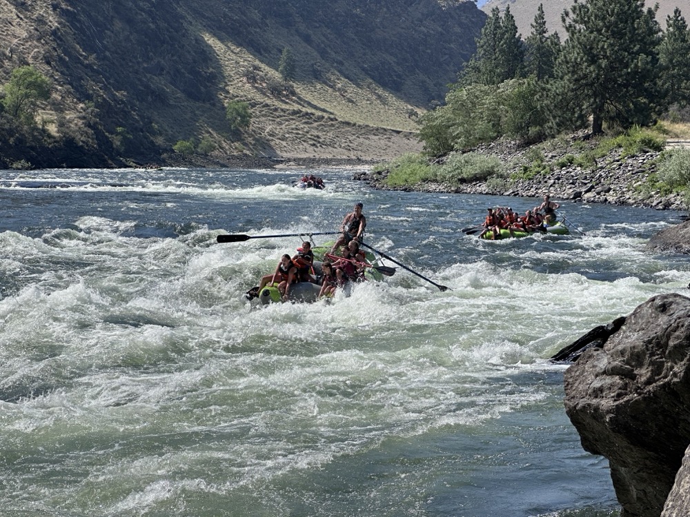
Mile 18.1 – Ruby Rapids
Class II-/III+. Under approximately 20,000 CFS, the Ruby rapid is mellow, largely rating as a Class II section with a well-defined channel and minor consequences for errors. As flows climb significantly into the 30,000–60,000 CFS range, the rapid begins to “wake up,” featuring increased speed, longer wave trains, and stronger lateral waves that add a greater challenge for boaters. The rapid tends to peak in its overall intensity around 60,000–70,000 CFS, where the waves become very large and long, the horizon line is more dramatic, and the channel is highly dynamic.
Mile 19.1 – Lake Creek Rapids
This Class III-IV rapid, located just before the Lake Creek Bridge, is a guide and guest favorite, delivering excitement across all water levels. At lower flows (under 20,000 cfs), the rapid becomes technical, requiring precise maneuvering around exposed rocks; conversely, at higher flows (e.g., 25,000 – 60,000 cfs), it ramps up dramatically with powerful features like Big Easy and Haystack. While the center line is generally runnable at all levels, high flows offer some of the largest, most exciting waves on the entire Salmon River.
Mile 19.3 – Lake Creek Bridge
The Lake Creek Bridge, located just upstream of Riggins, Idaho, was originally built in the late 1930s by the Civilian Conservation Corps (CCC) as part of a road project connecting Riggins to French Creek along the Salmon River. The first bridge, a narrow suspension span, was destroyed by fire in 1947 and later replaced with the modern steel-and-concrete structure that stands today. The bridge has long served as a vital link for river access and local travel—marking the famous Lake Creek Rapid and helping open this remote stretch of canyon to recreation and commerce.
Mile 20.0 – Cat’s Paw Rapid
Class III. Cat’s Rapid is a great wave train at most flows.
Mile 20.1 – Cat’s Paw Camp
River Right. After running Cat’s Paw Rapid, you’ll encounter Cat’s Paw camp on the right-hand side of the river. Lower Cat’s Paw is downstream of this.
Mile 20.3 – Lower Cat’s Paw
River Right. Lower Cat’s Paw is a large, sandy beach on the right.
Mile 20.8 – Peace Wave
Class II. Kayak surf wave forms on the right at 3,400 to 6,500 cfs. Large powerful holes are found on the left here at flows of 20,000 to 40,000 cfs.
Mile 20.8 – Hippy Beach
River Left. Hippy Beach is a large camp, close to Peace Wave.
Mile 21.2 – Mt. Mazama
River Right. The white line visible on the mountain is believed to be ash from Mt. Mazama (Crater Lake) about 6,700 years ago.
Mile 21.9 – Island Bar
River Left. Free public camping area. No amenities. Optional launch point. Undeveloped ramp. The campground on the bar becomes an Island at flows over about 36,000 cfs.
Mile 22.8 – Dugout Creek
River Right. Dugout Creek is on river right.
Mile 24.5 – Shorts Bar Ramp
River Left. Short Bar has a boat ramp, restrooms and camping. Large beaches are found in this area.
Mile 24.7 – Shorts Bar Camp
River Left. On the downstream end of Shorts Bar river access, there is a large beach for camping.
Mile 25.3 – Mill Wave
Class II. A Small surf wave forms here at 3,000 to 4,500 cfs
Mile 25.4 – Mill Wave Camp
River Right. Below the Mil Wave is a sandy beach on the right-hand side. It’s aptly-named Mill Wave Camp
Mile 25.6 – Little Salmon River
River Left. Confluence of the Little and “”Big”” Salmon Rivers. Popular Salmon fishery when Salmon travel upriver to the Rapid River Hatchery.
Mile 25.7 – Preacher Rock Rapid
Class II. Preacher Rock is a read and run rapid as you come into town.
Mile 26.2 – Riggins City Boat Ramp
River Left. Riggins City Boat Ramp has free parking, restrooms at the city boat ramp. The town of Riggins has groceries, equipment rentals, gas, lodging and guided trips available. Riggins has been known as Irwin Bar, Clay, and Gouge Eye. The post office declined the name Gouge Eye and name it after the first postmaster.
Mile 26.3 – Rob’s Rock
Named for legendary guide that slept here. Large rock in slow moving current.
Mile 26.8 – 911 Hole Rapid
Class II-III. On the top right, a large boulder forms the 911 hole at medium flows. At low flows, the rock is dry.
Mile 26.9 – Machine Wave
Class II. A small surf wave forms around 6,500 to 10,000 cfs on the right.
Mile 27.4 – Race Creek Surf Waves
Class II. At Race Creek Rapids, various surf waves form on the left at 24,000 to 50,000 cfs
Mile 27.5 – Race Creek Rapids
Class II. At low flows, only a slow ripple exists here. Large, surging waves are found here at medium to high flows.
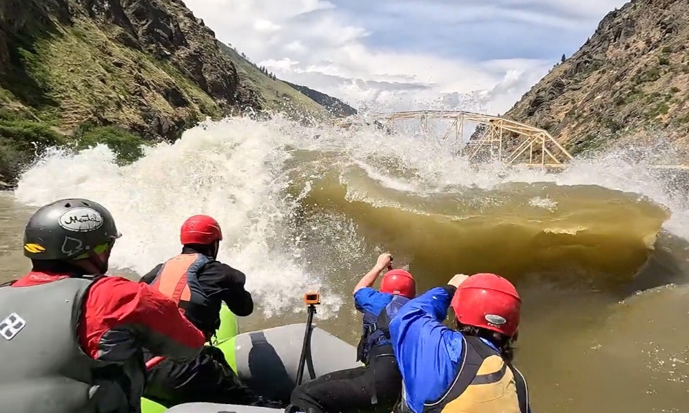
Mile 28.0 – Time Zone Rapids
Class III+. Time Zone Rapids are famous for the Time Zone Bridge and well known from the jetboat races held here. This is a long rapid with multiple different parts at lower flows. Medium to high flows have dangerous ledge holes on the right of center. Watch out for powerful eddy lines form on the right cliff wall at high flows.
Mile 28.1 – Time Zone Bridge
Right side of the river is now in Pacific time, left is in Mountain time. Adventure Idaho operates on mountain time.
Mile 28.5 – Tight Squeeze Rapid
Class III. Tight Squeeze Rapid washes out at high water. As the water drops, this a fun wave train that is a highlight for many.
It can flip rafts as the water drops around 5,000 cfs. Surf waves forms in the middle of the wave train around 5,000 to 7,500 cfs.
Mile 29.6 – Lightning Creek Rapid
Class II. Despite the name, not much whitewater is found here. Shocking.
Mile 29.7 – Lightning Creek Boat Ramp
River Right. Lightning Creek Boat Ramp is located on the downstream end of Lightning Creek Rapid. A primitive boat ramp is found here.
Mile 30.0 – Cherry Creek Rapid
Class II-III. Washed out at high flows. Gets more exciting as the water drops. Read and run.
Mile 30.6 – Chair Creek Rapid
Class III. Despite the unassuming name, Chair Creek packs powerful waves. Very large waves can be found on the right at flows over 30,000 cfs. Below 27,000, the entrance wave becomes a large hole.
Mile 31.3 – Traps Creek Rapid
Class II-IV. Traps Creek is washed out at most flows, but becomes the hardest rapid at low water. Difficulty increases as flows drop under 4,000. Peak difficulty around 3,200 cfs. Many rocks and holes abound in this steep drop.
Mile 31.6 – Fiddle Rapid
Class III+. Fiddle is a long rapid found wrapping around a slow right bend. Inside right always provides the cleanest line. Medium flows provide large hits down the middle. These become holes then rocks as the water drops.
Mile 31.9 – Fiddle Creek Fruit Stand
River Right. Fiddle Creek Fruit stand is known for its homemade pies. Somehow an entire Ace Hardware store fits into the back.
Mile 32.9 – Rodeo Hole
Class II. A surf wave forms here around 10,000 to 19,000 cfs
Mile 33.0 – Jackass Flat
River Right. Primitive boat ramp, camping and fruit trees found here.
Mile 33.7 – Black Rock Rapid
Class II/III. Black Rock Rapid is read and run at all flows.
Mile 33.8 – Black Rock Camp
River Left. Below Black Rock Rapid is Black Rock camp which is a nice camp with a large, sandy beach.
Mile 34.4 – Old Lucile Boat Ramp
River Right. Old Lucile Boat Ramp has a steep two-lane boat ramp and restrooms.
Mile 34.9 – Lucile Boat Ramp
Wide boat ramp, restrooms and abundant blackberries found here in July/Aug. Water available. This ramp comes up very quickly at high water. Taking out at Old Lucille recommended at flows over 35,000 cfs.