Forks of the Kern
Download the #1 app for rafting the Forks of the Kern
Southern California, USA
Forks of the Kern River Rafting Guide
When the water is right, the Forks of the Kern presents some of the most scenic, toughest, and fun boating in the West. Unimpeded by dams, the flows are highly variable year to year which makes the season hard to predict as it is snowpack and subsequent melt dependent. However, when the Forks is flowing, the water is clear, cool, and full of big, fun whitewater. Top to bottom this river section contains stout class IV, the occasional class V, and very little downtime.


This guide was written by Kern River Outfitters. Kern River Outfitters runs half, full, and two-day trips on the Upper, Lower, and Forks of the Kern. They have more five star reviews than any other rafting company in California. Learn more about them here.
About The Forks of the Kern
Commercially, the only way to see the Forks of the Kern trip is a two day. Privately, the vast majority of users opt for shorter trips, typically a day trip, commonly referred to as a “bullet run.” With a put-in that requires a 2 mile hike and no road support for 15 miles, the Forks is not for the faint of heart.
Directions
Take county road M99 from Kernville towards Johnsondale. Stash shuttle vehicles in the parking lot just after Johnsondale Bridge. Continue on M99 past the town of Johnsonale. A half mile past Johnsondale turn right onto forest road (2S82) toward Lloyds Meadow and follow it for 19 miles. After 19 miles, turn right onto forest road (20S67) at a sign labeled “Forks of the Kern.”* Follow this road for three miles until you reach the parking lot at Lloyd’s Meadow. The Forks trailhead is at the eastern tip of the meadow.
Google map directions are located here.
*As of August, 2019, this sign has been knocked down.
Getting to the river from the trailhead
While the hike is downhill, it is not easy. Private rafters strategically choose their gear based on weight and how comfortable it is to carry. This often means rolling rafts ‘burrito style’ and using two or more people to carry each raft. The halfway marker for the trail is a metal post in the middle of the path that is in the shade of a large oak tree. Alternatively, and what commercial rafting companies do, is you can hire a mule pack train to haul your equipment down. Golden Trout Pack Station is your only option for mules. We recommend making mule reservations well in advance.
Forks of the Kern Permits
Obtaining a Forks of the Kern permit is different than getting a Lower or Upper permit. Technically, it is a lottery system, allowing one group to launch per day of up to 15 people. However, there are many days where no one has applied for a permit and you can get one by calling the Forest Service. These walk-in/call-in permits are available after May 15, on a first come, first served basis. Please see this webpage for more information.
Safety
The Forks of the Kern is an advanced river run. On top of stout class IV and V whitewater, there are very few flat-water sections as well as numerous unnamed class II and III rapids. Due to the remoteness, this run isn’t seen as often as other sections of the Kern which means new hazards can appear that are otherwise unlisted; trees can appear, new strainers can form, and on some occasions, entire rapids have been known to shift. Pay attention, and always go with someone that has recent Forks experience.
4.8★★★★★ 23K+ Reviews
Rafting the Forks of the Kern? Our Kern River guide has you covered: 214 waypoints | Live location | 100 photos
$9.99 – Powered by FarOut


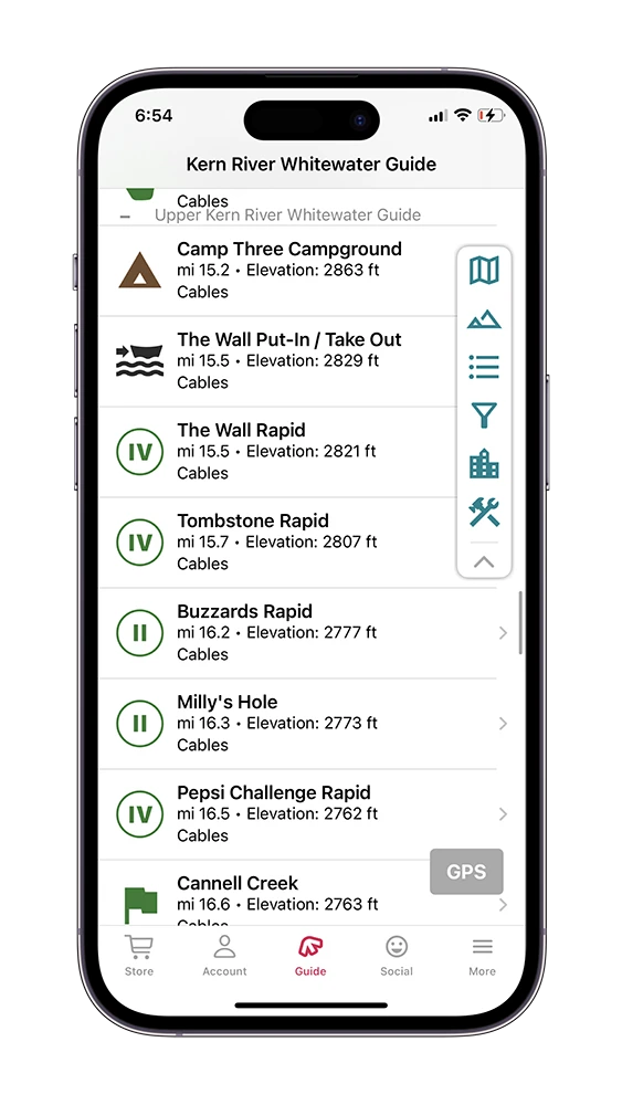
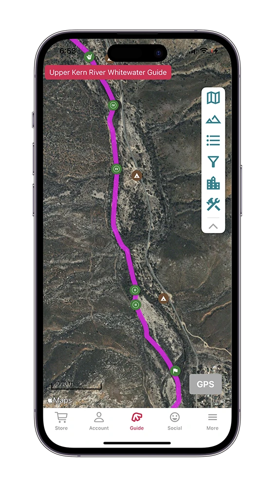
Forks Island to Johnsondale Bridge – Class III, IV and V
There is only one run on the Forks of the Kern, starting at the Forks Island. Technically, the run ends at Johnsondale Bridge, however, if you’re using rafts it is best to run the Class IV Limestone section of the Upper Kern down to Willow Point for a much easier take-out.
Forks of the Kern Trailhead:
The put-in is down a 2 mile trail starting at the Forks of the Kern trailhead at the end of state road 20S67 and ending at “the island” where the Little Kern and North Fork converge.
Mile 0.0 – The Island Put-in:
Wade across the Little Kern River to “The Island.” There are shaded eddies on the North Fork of the Kern River side of the island to rig boats and launch.
Mile 0.37 – Tune-Up Eddy:
River Right. After launching from the Forks Island, just downstream is Tune-Up Eddy. Use this eddy to make any last minute adjustments to your oars, frame or paddling crew.
Mile 0.54 – Welcome to the Forks Rapid:
Class III. A good warm-up for what’s to come, choose a technical, shallow line down either the far right or far left side.
Mile 0.71 – Walking Tall Rapid:
Class III. Run straight down the middle. Watch out for a ledge on river right at lower flows.
Mile 2.83 – Freeman Creek:
River Right. About 100 yards up the creek is a scenic waterfall and swimming hole. It also allows an opportunity to scout the first Class IV below.
Mile 2.85 – Upper Freeman Rapid:
Class IV. Good route far right.
Mile 3.00 – Lower Freeman Rapid:
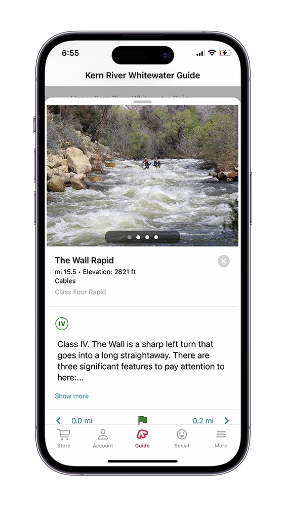
Class IV-V. Scout this rapid on river left. The normal run starts on river left and cuts right. Push hard to get close to the far shore at the apex of the river bend. Often, paddle boats go for an upstream spin as they come around the turn, and paddle hard with an upstream right angle to get away from the “gnarnia hole” at the bottom of the rapid on river right. This hole flips more boats than any other one on the river. There is about 50 meters of slow moving water and opportunities to set safety for the rapid downstream on river left. At higher flows a channel opens up far river left to sneak the main drop and other obstacles.
Mile 3.45 – Wrapid Rapid:
Class IV. Giant S-turn with wrap rocks. Cut hard behind the large boulder to avoid wrap rocks on river left.
Mile 4.45 – Needlerock Rapid:
Class IV. The normal line is a steep and narrow far right chute. Maintain a left angle and momentum to avoid getting slammed into the river right wall.
Mile 4.45 – Needlerock Creek:
River Right. Located in the middle of Needlerock Rapid, the creek cascades into the river here. In early season or big water years, the creek enters the river as a tiered waterfall.
Mile 4.54 – Needlerock Camp:
River Left. This is located just below the rapid. This is a beautiful campsite with a fire pit, plenty of flat space, and unbeatable views of Needlerock Falls and the Needles themselves. Hike upstream until you reach a large boulder that has the best view. In the late spring, Needle Rock camp is known for being filled with ladybugs.
Mile 4.57 – Downhill Rapid:
Class IV. Long, and fun rapid. Make your way to river right to avoid the bottom hole that is big at medium to high flows that’s located left and center.
Mile 4.74 – Slalom Rapid:
Class IV. Immediately after Downhill Rapid, this run starts on river right above a large jumble of boulders in the center of the river. Take a slot moving left into the rapid and weave a line down the center-left side. About half-way down make a sneaky cut back right through rocks and finish the rapid on the right side.
Mile 6.05 – Surf’s Up Rapid:
Class III. Enter right or left and make your way to the left side of the river. About half-way down at high flows tee up and type-writer a large left-trending lateral to finish left of a large rock at the bottom.
Mile 6.57 – View Camp:
River Left. Large, flat campground with gorgeous views of the Needles.
Mile 6.83 – Durwood Wall:
Class III. Run from river left to river right. Watch out for wild boil lines that push off the wall at the bottom of the rapid.
Mile 6.93 – Durwood Creek:
River Left. Spring-fed creek that flows into the Kern River.
Mile 7.12 – Durwood Lodge Camp:
River Left. Durwood Lodge campground is a large campsite with remnants of an old lodge to explore. This is the most popular halfway point campsite on the Forks. There are permanent tables and a fire pit to enjoy.
Mile 7.15 – Durwood Rapid:
Class III. The normal line is on river right.
Mile 8.07 – Peppermint Creek:
River Right. Hike away from the river via the trail upstream of Peppermint Creek. The waterfall is very scenic and you can climb underneath it. Be careful though, it is very slippery.
Mile 8.58 – Little Bean Rapid:
Class IV. Enter on the left side of the rapid, just to the right of the tree island. Get leftwards momentum to cut across the rapid and avoid the “bean” in the center of the river that is notorious for sending people swimming into the calm pool below.
Mile 8.60 – Little Bean Camp:
River Right. Catch the eddy river right just downstream of Little Bean Rapid. The camp is the flat area just past the trees. This camp is seldom used, but a good spot to stop if you are losing daylight or need to break.
Mile 8.69 – Big Bean Rapid:
Class IV. Start in the middle of the river and cut left to set up for the main drop. Look for the “pyramid rock” that is in the center of the river and marks the top of the drop. Take the drop just to the left of the pyramid rock with a left angle and momentum. Move to river right after the drop to avoid rocks and holes in the center of the river.
Mile 9.05 – Bridgework Rapid:
Class III. The rapid is on the left side of the island in the middle of the river. Hug the island as you make your way down the right side of the left channel. In the early ’90s a KRO guide, John Bishop, let his downstream oar go a bit too deep. It popped back at him, hit him square in the mouth, and took out his top four front teeth. A few days later he had a bridge made to replace his teeth and the rapid was named “bridgework” to serve as a cautionary tale.
Mile 9.51 – Vortex Rapid:
Class V+. Mandatory scout on river right 100 yards above the rapid. This rapid is portaged frequently on river left by pulling the rafts up and over a rock pile and starting in a pool just below the rapid. You can scout the approach to the portage on river right. At most flows the center drop of Vortex creates a massive, recirculating hydraulic with boil lines over 10 ft out. The normal run starts far on river right, and depending on the flows, exits far right, or cuts across the river to a left exit. Only run this rapid with extremely experienced boaters, and with thorough safety set up throughout.
Mile 9.59 – Gortex Rapid:
Class V. This rapid begins just below Vortex. The Gortex hole is a large hole on river left. At most flows, rafters “sneak” Gortex via a boat width slot on river right. This is because of the extremely limited recovery time between Gortex and the Gauntlet. If you have portaged Vortex, ferry hard to get to river right when coming out of the pool to avoid running Gortex, and to avoid a large hole just downstream of the portage eddy on river left.
Mile 9.71 – Gauntlet Rapid:
Class V. This rapid can be scouted on river left via a long walk from the Vortex portage eddy. The walk takes about 10 minutes each way and involves some scrambling. At high flows it is possible to avoid the “Hawaii Five-0” hole by running on the right side of the rapid before cutting left below the main center holes. If you run the top “Hawaii Five-0” hole, do so with a left angle to try to get to the left of the massive holes in the middle of the rapid. Run these straight on if you need to. Watch out for a log-sieve two thirds of the way down the rapid on river right.
Mile 10.15 – The Maze Rapid:
Class IV. Take the top drop on river right and make your way behind the big boulder in the center of the river. Cut left just behind the boulder.
Mile 10.68 – Four Mile Trail:
River Left. This trail, as the name indicates, is a four mile trail that starts at Johnsondale Bridge (take-out) and runs alongside the river and at this point, leaves the river corridor.
Mile 10.71 – Four Mile Rapid:
Class IV. Start in the middle, cut left to avoid holes at the top, and then cut right hard across the river to get just to the right of the large boulder at the bottom center of the rapid.
Mile 10.91 – Rincon Rapid:
Class IV. Rincon rapid marks the beginning of a continuous technical class IV section known as “The Geologies.” Drop in with a right angle just to the left of the large boulder above a wide, retentive hole.
Mile 11.11 – Metamorphosis Rapid:
Class IV. This is a very technical rapid best run by cutting from river right to river left through the boulder field.
Mile 11.35 – Rest Eddy:
River Right. This is the only eddy in The Geologies that is big enough for 4-6 rafts to eddy out together. It is a good place to pause and take a break before entering Basalt Rapid.
Mile 11.41 – Basalt Rapid:
Class IV. This run starts on river left, and then cuts back to the center of the river. Take the main drop just to the right of a large boulder in the middle of the river. Watch out for nub rocks sticking out just above the main drop.
Mile 12.16 – Confusion Camp:
River Right. On river right is Confusion Campground. The eddy is very small and boats need to enter one at a time. There is a large flat camping area up the gravel bar away from the river.
Mile 12.21 – Chaos Rapid:
Class IV. This rapid leads into Confusion, and many people think of it as one long rapid. Both rapids can be scouted from river left along the Four Mile Trail. The run winds around holes between river right and the center of the river before cutting hard to river left after hitting a big hole on river right just to the right of a large boulder. There is a small “scout eddy” that it is possible to catch on river left before Confusion.
Mile 12.31 – Confusion Rapid:
Class V. True to its name, Confusion Rapid is also hard to describe. Enter left of center. Move right below the picket fence rocks to the river right of the flat slide rock. Stay right as you head downstream to avoid the “whales tail” rock sieve on River Left. There are a series of large holes. Run them on the right corner of each hole. The last hole, “the catcher’s mitt,” is the largest. The dice rock just downstream is undercut. At higher flows, you can take the steep drop facing river right just above the catchers mitt and avoid the hole completely. Some old guidebooks and river guides call this rapid “Westwall.”
Mile 12.71 – Dry Meadow Creek:
River Right. This creek runs into the river and allows access to the Seven Teacups. Be ready for a steep climb along the right side (perspective from the Kern) of Dry Meadow to get outstanding views of waterfalls. Note that this hike is not for the faint of heart. The thirty-foot slide that enters the Kern is an excellent natural waterslide and ends in a calm pool.
Mile 13.31 – Respect Rapid:
Class IV. There are two rapids that look very similar to Respect. The actual Respect rapid is the second of the two. Start in the center-right of the river and get a left angle to cut just behind the boulder in the middle. There is a large, boat surfing hole, just downstream of the boulder.
Mile 13.61 – Maytag Rapid:
Class IV. This rapid starts just left of center, and cuts to river left to avoid the large “Maytag Hole” at the bottom of the rapid.
Mile 14.01 – Carson Falls Rapid:
Class V. The grand finale of the Forks, Carson Falls is a large, Class V drop with a technical entrance and challenging downstream features.
Mile 14.71 – Johnsondale Bridge Take-out:
River Right. There is a steep concrete ramp to get back to the parking lot where takeout cars are parked. Consider moving cars to the Limestone takeout and enjoy a couple more miles of whitewater and an easier takeout.
Johnsondale Bridge to Willow Point – Class II, III & IV
There is only one run on the Forks of the Kern, starting at the Forks Island. Technically, the run ends at Johnsondale Bridge, however, if you’re using rafts it is best to run the Class IV Limestone section of the Upper Kern down to Willow Point for a much easier take-out. Those rapids are summarized below, but their in-depth descriptions are available on the Upper Kern guide page.
Mile 14.76 – Bridge Rapid:
Class II. Take the left channel. (Even if there is enough water, the right channel is often choked with logs.) Enter far left near the shore. At low water the tree far left at the entrance comes into play, so be aware. Read and run the holes and waves as you move center and then right.
Mile 15.30 – Brush Creek Rapid:
Class II/III. Brush creek makes a right hand turn. Read and run through the rocks.
Mile 15.57 – Limestone Rapid:
Class IV. Enter down the right side to avoid an entrance hole and as you make the turn work back left to avoid rocks and holes on the bottom right.
Mile 15.67 – Limestone Campground:
River Left. This campground is located on River Left and offers gorgeous views of the rapid.
Mile 15.90 – Joe’s Diner:
Class III/IV. A multifaceted rapid, you will want to start on river right and ferry to the left, inside corner to avoid holes on river right. After making the turn look out for the rock/pour over known as The Greasy Spoon.
Mile 16.17 – Betty’s Bakery:
Class III/IV. A two-part adventure; as the river makes a sharp right turn after Joe’s Diner stay in the center, avoiding a nasty recirculating hole on river left. After this first section pick your way through boulders and pour-overs down a straightaway to finish the rapid.
Mile 17.11 – Willow Point Take-Out:
River Left. If you are using this as a take-out, be sure to catch the eddy on river left at the bottom of the rapid. This is the last take-out before getting to the Fairview Dam. It is very hard to pull a boat back upstream if you miss this.